

Sacramento Surveyors Visit the NGS Airborne Gravimeter - CLSA
Sacramento Surveyors Visit the NGS Airborne Gravimeter - CLSA
Sacramento Surveyors Visit the NGS Airborne Gravimeter - CLSA

Create successful ePaper yourself
Turn your PDF publications into a flip-book with our unique Google optimized e-Paper software.
Positioning using GPS and CORS<br />
Continued from previous page<br />
on <strong>the</strong> market and assigned very specific abbreviations<br />
denoting <strong>the</strong> manufacturer, model and version of a particular<br />
antenna. If you are processing GPS data using your own<br />
proprietary software, <strong>the</strong> offsets for each antenna model<br />
used in your survey must be properly applied. If you are<br />
submitting your GPS data in RINEX format to an online<br />
service, <strong>the</strong> proper abbreviations for your antenna model(s)<br />
must be used in order for <strong>the</strong> proper offsets to be assigned<br />
by <strong>the</strong> online service. To see a list of <strong>NGS</strong> antenna models<br />
and <strong>the</strong>ir observed offsets, go to<br />
http://www.ngs.noaa.gov/ANTCAL/.<br />
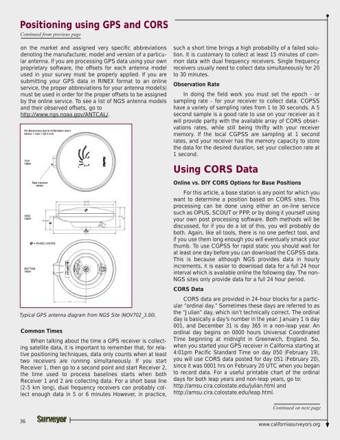
Typical GPS antenna diagram from <strong>NGS</strong> Site (NOV702_3.00).<br />
Common Times<br />
When talking about <strong>the</strong> time a GPS receiver is collecting<br />
satellite data, it is important to remember that, for relative<br />
positioning techniques, data only counts when at least<br />
two receivers are running simultaneously. If you start<br />
Receiver 1, <strong>the</strong>n go to a second point and start Receiver 2,<br />
<strong>the</strong> time used to process baselines starts when both<br />
Receiver 1 and 2 are collecting data. For a short base line<br />
(2-5 km long), dual frequency receivers can probably collect<br />
enough data in 5 or 6 minutes However, in practice,<br />
such a short time brings a high probability of a failed solution.<br />
It is customary to collect at least 15 minutes of common<br />
data with dual frequency receivers. Single frequency<br />
receivers usually need to collect data simultaneously for 20<br />
to 30 minutes.<br />
Observation Rate<br />
In doing <strong>the</strong> field work you must set <strong>the</strong> epoch - or<br />
sampling rate - for your receiver to collect data. CGPSS<br />
have a variety of sampling rates from 1 to 30 seconds. A 5<br />
second sample is a good rate to use on your receiver as it<br />
will provide parity with <strong>the</strong> available array of CORS observations<br />
rates, while still being thrifty with your receiver<br />
memory. If <strong>the</strong> local CGPSS are sampling at 1 second<br />
rates, and your receiver has <strong>the</strong> memory capacity to store<br />
<strong>the</strong> data for <strong>the</strong> desired duration, set your collection rate at<br />
1 second.<br />
Using CORS Data<br />
Online vs. DIY CORS Options for Base Positions<br />
For this article, a base station is any point for which you<br />
want to determine a position based on CORS sites. This<br />
processing can be done using ei<strong>the</strong>r an on-line service<br />
such as OPUS, SCOUT or PPP, or by doing it yourself using<br />
your own post processing software. Both methods will be<br />
discussed, for if you do a lot of this, you will probably do<br />
both. Again, like all tools, <strong>the</strong>re is no one perfect tool, and<br />
if you use <strong>the</strong>m long enough you will eventually smack your<br />
thumb. To use CGPSS for rapid static you should wait for<br />
at least one day before you can download <strong>the</strong> CGPSS data.<br />
This is because although <strong>NGS</strong> provides data in hourly<br />
increments, it is easier to download data for a full 24 hour<br />
interval which is available online <strong>the</strong> following day. The non-<br />
<strong>NGS</strong> sites only provide data for a full 24 hour period.<br />
CORS Data<br />
CORS data are provided in 24-hour blocks for a particular<br />
“ordinal day.” Sometimes <strong>the</strong>se days are referred to as<br />
<strong>the</strong> “Julian” day, which isn’t technically correct. The ordinal<br />
day is basically a day’s number in <strong>the</strong> year: January 1 is day<br />
001, and December 31 is day 365 in a non-leap year. An<br />
ordinal day begins on 0000 hours Universal Coordinated<br />
Time beginning at midnight in Greenwich, England. So,<br />
when you started your GPS receiver in California starting at<br />
4:01pm Pacific Standard Time on day 050 (February 19),<br />
you will use CORS data posted for day 051 (February 20),<br />
since it was 0001 hrs on February 20 UTC when you began<br />
to record data. For a useful printable chart of <strong>the</strong> ordinal<br />
days for both leap years and non-leap years, go to:<br />
http://amsu.cira.colostate.edu/julian.html and<br />
http://amsu.cira.colostate.edu/leap.html.<br />
Continued on next page<br />
36<br />
www.californiasurveyors.org


