INTRODUCTION TO ARCHAEOLOGY Nancy White - Touro Institute
INTRODUCTION TO ARCHAEOLOGY Nancy White - Touro Institute
INTRODUCTION TO ARCHAEOLOGY Nancy White - Touro Institute

You also want an ePaper? Increase the reach of your titles
YUMPU automatically turns print PDFs into web optimized ePapers that Google loves.
What other technological devices must modern<br />
archaeologists use? Lately we must have a Global<br />
Positioning System (GPS) unit, which reads signals<br />
bouncing off several satellites to give exact locations<br />
in latitude/longitude or other coordinates. We also<br />
want to utilize Geographic Information Systems (GIS),<br />
which are simply computerized ways of making maps<br />
of different features that can be overlain to show<br />
relationships of natural and cultural features through<br />
time.<br />
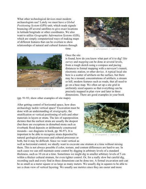
Once the site<br />
is found, how do you know what part of it to dig? Site<br />
survey and mapping can be done at several levels,<br />
from a rough sketch using a compass and pacing<br />
distances to formal mapping with a surveyor’s transit,<br />
electronic station, or other device. A typical local site<br />
here is a scatter of artifacts on the surface, but there<br />
may be a mound, concentrations of artifacts, a stream<br />
or hill, modern features such as roads, that all need to<br />
go on a base map. We often set up a site grid in<br />
uniformly sized squares so that everything can be<br />
precisely mapped in plan view and later in three<br />
dimensions. There are good examples in your book<br />
(pp. 91-93; show other examples of site maps).<br />
After getting control of horizontal space, how does<br />
archaeology tackle vertical space? Excavation must be<br />
done with an understanding of stratigraphy, the<br />
stratification or vertical positioning of soils and other<br />
materials in layers or strata. The law of superposition<br />
dictates that the earliest strata are usually the deepest<br />
(but there are exceptions in disturbed strata such as<br />
riverbank flood deposits or deliberately constructed<br />
mounds—see diagrams in book, pp. 96-97). It is<br />
important to be able to recognize strata deposited by<br />
natural geological processes and cultural processes or<br />
both, but it may be difficult. Since we want vertical as<br />
well as horizontal control, we ideally want to excavate one stratum at a time without mixing<br />
them. This is not always possible if color, texture, and content differences are hard to see. In<br />
such cases we can still maintain some control by digging in arbitrary levels of a standard<br />
thickness, such as 10 cm at a time. Sometimes we might dig in smaller arbitrary levels of 5 cm<br />
within a thicker cultural stratum, for even tighter control. Or, for a really slow but careful dig,<br />
recording each and every find in three dimensions can be done too. A formal excavation unit can<br />
be as small as a meter square or as large as many meters. We usually dig in squares to be able to<br />
see a clean view of vertical layering. We usually use metrics since they are easier and more