Download issue (PDF) - Nieman Foundation - Harvard University
Download issue (PDF) - Nieman Foundation - Harvard University
Download issue (PDF) - Nieman Foundation - Harvard University

You also want an ePaper? Increase the reach of your titles
YUMPU automatically turns print PDFs into web optimized ePapers that Google loves.
Coverage of Terrorism<br />
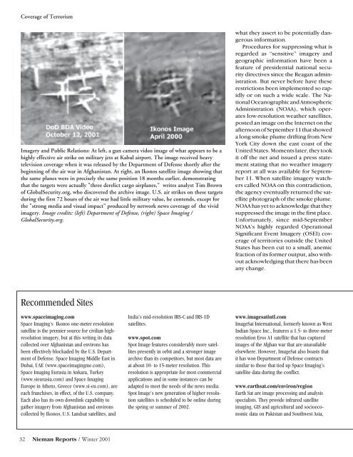
Imagery and Public Relations: At left, a gun camera video image of what appears to be a<br />
highly effective air strike on military jets at Kabul airport. The image received heavy<br />
television coverage when it was released by the Department of Defense shortly after the<br />
beginning of the air war in Afghanistan. At right, an Ikonos satellite image showing that<br />
the same planes were in precisely the same position 18 months earlier, demonstrating<br />
that the targets were actually "three derelict cargo airplanes," writes analyst Tim Brown<br />
of GlobalSecurity.org, who discovered the archive image. U.S. air strikes on these targets<br />
during the first 72 hours of the air war had little military value, he contends, except for<br />
the "strong media and visual impact" produced by network news coverage of the vivid<br />
imagery. Image credits: (left) Department of Defense, (right) Space Imaging /<br />
GlobalSecurity.org.<br />
what they assert to be potentially dangerous<br />
information.<br />
Procedures for suppressing what is<br />
regarded as “sensitive” imagery and<br />
geographic information have been a<br />
feature of presidential national security<br />
directives since the Reagan administration.<br />
But never before have these<br />
restrictions been implemented so rapidly<br />
or on such a wide scale. The National<br />
Oceanographic and Atmospheric<br />
Administration (NOAA), which operates<br />
low-resolution weather satellites,<br />
posted an image on the Internet on the<br />
afternoon of September 11 that showed<br />
a long smoke plume drifting from New<br />
York City down the east coast of the<br />
United States. Moments later, they took<br />
it off the net and <strong>issue</strong>d a press statement<br />
stating that no weather imagery<br />
report at all was available for September<br />
11. When satellite imagery watchers<br />
called NOAA on this contradiction,<br />
the agency eventually returned the satellite<br />
photograph of the smoke plume.<br />
NOAA has yet to acknowledge that they<br />
suppressed the image in the first place.<br />
Unfortunately, since mid-September<br />
NOAA’s highly regarded Operational<br />
Significant Event Imagery (OSEI) coverage<br />
of territories outside the United<br />
States has been cut to a small, anemic<br />
fraction of its former output, also without<br />
acknowledging that there has been<br />
any change.<br />
Recommended Sites<br />
www.spaceimaging.com<br />
Space Imaging’s Ikonos one-meter resolution<br />
satellite is the premier source for civilian highresolution<br />
imagery, but at this writing its data<br />
collected over Afghanistan and environs has<br />
been effectively blockaded by the U.S. Department<br />
of Defense. Space Imaging Middle East in<br />
Dubai, UAE (www.spaceimagingme.com),<br />
Space Imaging Eurasia in Ankara, Turkey<br />
(www.sieurasia.com) and Space Imaging<br />
Europe in Athens, Greece (www.si-eu.com), are<br />
each franchises, in effect, of the U.S. company.<br />
Each also has its own downlink capability to<br />
gather imagery from Afghanistan and environs<br />
collected by Ikonos, U.S. Landsat satellites, and<br />
India’s mid-resolution IRS-C and IRS-1D<br />
satellites.<br />
www.spot.com<br />
Spot Image features considerably more satellites<br />
presently in orbit and a stronger image<br />
archive than its competitors, but most data are<br />
at about 10- to 15-meter resolution. This<br />
resolution is appropriate for most commercial<br />
applications and in some instances can be<br />
adapted to meet the needs of the news media.<br />
Spot Image’s new generation of higher resolution<br />
satellites is scheduled to be online during<br />
the spring or summer of 2002.<br />
www.imagesatintl.com<br />
ImageSat International, formerly known as West<br />
Indian Space Inc., features a 1.5- to three-meter<br />
resolution Eros A1 satellite that has captured<br />
images of the Afghan war that are unavailable<br />
elsewhere. However, ImageSat also boasts that<br />
it has won Department of Defense contracts<br />
similar to those that tied up Space Imaging’s<br />
satellite data during the conflict.<br />
www.earthsat.com/environ/region<br />
Earth Sat are image processing and analysis<br />
specialists. They provide infrared satellite<br />
imaging, GIS and agricultural and socioeconomic<br />
data on Pakistan and Southwest Asia,<br />
32 <strong>Nieman</strong> Reports / Winter 2001