

bc8G2-7
bc8G2-7
bc8G2-7

You also want an ePaper? Increase the reach of your titles
YUMPU automatically turns print PDFs into web optimized ePapers that Google loves.
58<br />
DOING BUSINESS 2015<br />
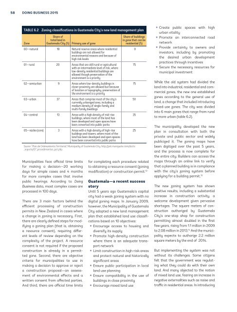
TABLE 6.2<br />
Zone<br />
Zoning classifications in Guatemala City’s new land management plan<br />
Share of<br />
total land in<br />
Guatemala City (%)<br />
Municipalities face official time limits<br />
for making a decision—20 working<br />
days for simple cases and 4 months<br />
for more complex cases that involve<br />
public hearings. According to Doing<br />
Business data, most complex cases are<br />
processed in 100 days.<br />
Primary use of zone<br />
G0—natural 18 Natural reserve areas where residential<br />
buildings are not allowed for<br />
environmental reasons and because of<br />
high risk levels<br />
G1—rural 20 Areas that are still rural or agricultural<br />
with an intermediate level of risk, where<br />
low-density residential buildings are<br />
allowed though preservation of the<br />
environment is a priority<br />
G2—semiurban 9 Areas where low-density buildings in<br />
closer proximity are allowed but because<br />
of location or topography, preservation of<br />
the environment is a priority<br />
G3—urban 37 Areas that comprise most of the city’s<br />
currently urbanized area, including a<br />
medium density of single-family and<br />
multi-family dwellings<br />
G4—central 13 Areas with a high density of mid-rise<br />
buildings, where most of the land has<br />
been developed and open spaces have<br />
been converted into public parks<br />
G5—núcleo (core) 3 Areas with a high density of high-rise<br />
buildings and towers, where most of the<br />
land has been developed and open spaces<br />
have been converted into public parks<br />
There are 3 main factors behind the<br />
efficient processing of construction<br />
permits in New Zealand in cases where<br />
a change in zoning is necessary. First,<br />
there are clearly defined steps for modifying<br />
a zoning plan (that is, obtaining<br />
a resource consent), requiring different<br />
levels of review depending on the<br />
complexity of the project. A resource<br />
consent is not required if the proposed<br />
construction is already in a permitted<br />
zone. Second, there are objective<br />
criteria for municipalities to use in<br />
making a decision to approve or reject<br />
a construction proposal—an assessment<br />
of environmental effects and a<br />
written consent from affected parties.<br />
And third, there are official time limits<br />
Share of buildings<br />
in zone that can be<br />
residential (%)<br />
Source: “Plan de Ordenamiento Territorial,” Municipality of Guatemala City, http://pot.muniguate.com/docts<br />
_soporte/07_procedimientos_pot.php.<br />
for completing each procedure related<br />
to obtaining a resource consent (zoning<br />
modification) or construction permit. 12<br />
Guatemala—a recent success<br />
story<br />
Until 5 years ago Guatemala’s capital<br />
city had a weak zoning system with no<br />
digital zoning maps. In January 2009,<br />
however, the Municipality of Guatemala<br />
City adopted a new land management<br />
plan that established land use classifications<br />
based on 10 objectives:<br />
• Encourage access to housing and<br />
diversify its supply<br />
• Promote high-density construction<br />
where there is an adequate transport<br />
network<br />
• Limit construction in high-risk areas<br />
and protect natural and historically<br />
significant areas<br />
• Ensure public participation in local<br />
land use planning<br />
• Ensure compatibility in the use of<br />
buildings in close proximity<br />
• Encourage mixed land use<br />
0<br />
75<br />
75<br />
50<br />
35<br />
25<br />
• Create public spaces with high<br />
urban vitality<br />
• Promote an interconnected road<br />
network<br />
• Provide certainty to owners and<br />
investors, including by promoting<br />
the desired urban development<br />
practices through incentives<br />
• Secure the necessary resources for<br />
municipal investment<br />
While the old system had divided the<br />
land into industrial, residential and commercial<br />
zones, the new one established<br />
zones according to the general use of<br />
land, a change that included introducing<br />
mixed-use zones. The city was divided<br />
into 6 main zones that range from rural<br />
to more urban (table 6.2).<br />
The municipality developed the new<br />
plan in consultation with both the<br />
private and public sector and widely<br />
publicized it. The zoning maps have<br />
been digitized over the past 5 years,<br />
and the process is now complete for<br />
the entire city. Builders can access the<br />
maps through an online link to verify<br />
that a planned building is in compliance<br />
with the city’s zoning system before<br />
applying for a building permit. 13<br />
The new zoning system has shown<br />
positive results, including a substantial<br />
increase in construction activity, a<br />
welcome development given pervasive<br />
shortages. The square meters of construction<br />
authorized by Guatemala<br />
City’s one-stop shop for construction<br />
permitting almost doubled in the first<br />
few years, rising from 1.1 million in 2009<br />
to 2.08 million in 2013. 14 And the municipality<br />
expects to authorize 2.2 million<br />
square meters by the end of 2014.<br />
But implementing the system was not<br />
without its challenges. Some citizens<br />
felt that the government was regulating<br />
what they could do with their own<br />
land. And many objected to the notion<br />
of mixed land use, fearing an increase in<br />
negative externalities such as noise and<br />
traffic in residential areas. In introducing