

bc8G2-7
bc8G2-7
bc8G2-7

Create successful ePaper yourself
Turn your PDF publications into a flip-book with our unique Google optimized e-Paper software.
62<br />
DOING BUSINESS 2015<br />
coverage of property taxes. 7 A case in<br />
point was the Maputo Structure Plan<br />
in Mozambique—an initiative to collect<br />
geographic data that was aimed<br />
at aiding the physical development<br />
of the capital but that also has the<br />
potential to help further improve the<br />
collection of property taxes. 8 Today,<br />
half of economies around the world<br />
have a geographic information system<br />
in place—a computerized system<br />
that can capture, store and analyze<br />
geographic data. While most are highincome<br />
economies, some are low- and<br />
middle-income economies. In Sub-<br />
Saharan Africa, for example, South<br />
Africa and Swaziland both have an<br />
electronic database to record property<br />
boundaries, check maps and provide<br />
updated geographic information on<br />
land parcels.<br />
Linking the land registry with the<br />
cadastral system has important<br />
advantages. It helps in maintaining<br />
up-to-date records on the legal rights<br />
to properties and the spatial characteristics<br />
of land plots, thus increasing<br />
tenure security. And it provides a single<br />
point of contact for those conducting<br />
land transactions. 9 In recent years<br />
several economies, mostly in Europe<br />
and Central Asia, have merged their<br />
land registries and cadastral systems.<br />
For example, the Russian Federation<br />
created a unified electronic land and<br />
property registry in 2013 by merging<br />
the state registry of immovable property<br />
and the state topographical and<br />
cadastral mapping system.<br />
Having all agencies use a single identification<br />
number for property is also<br />
beneficial. It allows quick identification<br />
of the legal status of a parcel, providing<br />
greater certainty for the parties<br />
engaged in a transfer of property and<br />
reducing the likelihood of mistakes.<br />
A majority of economies use a single<br />
identification number, with the highest<br />
shares doing so in Europe and Central<br />
Asia, the OECD high-income group and<br />
the Middle East and North Africa.<br />
HOW DOES TRANSPARENCY<br />
SUPPORT QUALITY?<br />
Transparency is a key element in the<br />
quality of land administration systems.<br />
It helps eliminate asymmetries in information<br />
between users and officials<br />
in a land administration system and<br />
increases the efficiency of the land<br />
market. 10 Doing Business has collected<br />
data about transparency through a set<br />
of questions focusing on who has access<br />
to land information, whether the<br />
fee schedule for land registry services<br />
is publicly available, whether there are<br />
service standards for property transactions,<br />
whether statistics about land<br />
transactions are collected and made<br />
available to the public and whether any<br />
specific mechanism is in place for filing<br />
a complaint.<br />
Transparency in a land administration<br />
system provides a defense against<br />
requirements for informal payments,<br />
such as to register property, change<br />
a title, acquire information on land or<br />
process cadastral surveys. Complicated<br />
processes and limited availability of<br />
information in the land sector facilitate<br />
such bribery. 11 But a transparent land<br />
administration system—one in which<br />
all land-related information is publicly<br />
available, all procedures and property<br />
transactions are clear, and information<br />
on fees for public services is easy to<br />
access—minimizes the possibilities for<br />
informal payments and abuses of the<br />
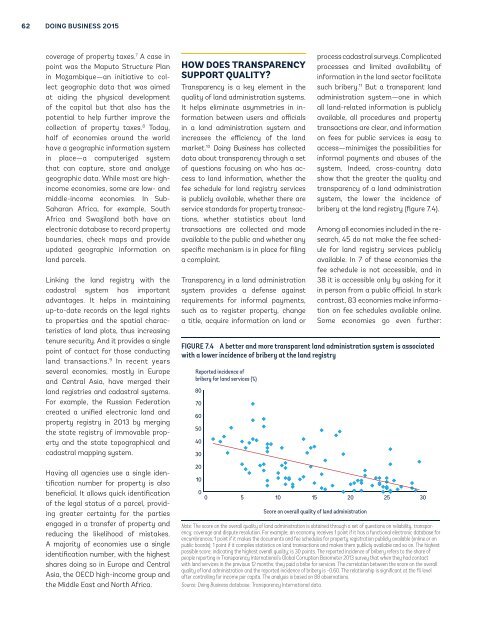
system. Indeed, cross-country data<br />
show that the greater the quality and<br />
transparency of a land administration<br />
system, the lower the incidence of<br />
bribery at the land registry (figure 7.4).<br />
Among all economies included in the research,<br />
45 do not make the fee schedule<br />
for land registry services publicly<br />
available. In 7 of these economies the<br />
fee schedule is not accessible, and in<br />
38 it is accessible only by asking for it<br />
in person from a public official. In stark<br />
contrast, 83 economies make information<br />
on fee schedules available online.<br />
Some economies go even further:<br />
FIGURE 7.4 A better and more transparent land administration system is associated<br />
with a lower incidence of bribery at the land registry<br />
Reported incidence of<br />
bribery for land services (%)<br />
80<br />
70<br />
60<br />
50<br />
40<br />
30<br />
20<br />
10<br />
0<br />
0 5 10 15 20 25 30<br />
Score on overall quality of land administration<br />
Note: The score on the overall quality of land administration is obtained through a set of questions on reliability, transparency;<br />
coverage and dispute resolution. For example; an economy receives 1 point if it has a functional electronic database for<br />
encumbrances; 1 point if it makes the documents and fee schedules for property registration publicly available (online or on<br />
public boards); 1 point if it compiles statistics on land transactions and makes them publicly available and so on. The highest<br />
possible score; indicating the highest overall quality; is 30 points. The reported incidence of bribery refers to the share of<br />
people reporting in Transparency International’s Global Corruption Barometer 2013 survey that when they had contact<br />
with land services in the previous 12 months; they paid a bribe for services. The correlation between the score on the overall<br />
quality of land administration and the reported incidence of bribery is −0.60. The relationship is significant at the 1% level<br />
after controlling for income per capita. The analysis is based on 88 observations.<br />
Source: Doing Business database; Transparency International data.