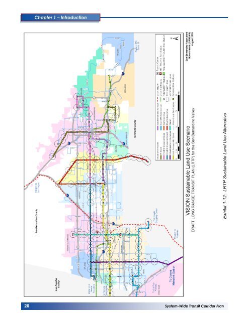
Chapter 1 – Introduction Exhibit 1-12: LRTP Sustainable Land Use Alternative 20 <strong>System</strong>-<strong>Wide</strong> <strong>Transit</strong> <strong>Corridor</strong> <strong>Plan</strong> 132
1.6 Regionally Approved Travel Demand Model The <strong>San</strong> Bernardino Valley Focus Model (SBVFM) is used to produce transit ridership <strong>for</strong>ecasts <strong>for</strong> <strong>the</strong> <strong>System</strong>-<strong>Wide</strong> <strong>Transit</strong> <strong>Corridor</strong> <strong>Plan</strong>. The SBVFM was derived from <strong>the</strong> SCAG regional travel model, and focused to produce travel <strong>for</strong>ecasts <strong>for</strong> <strong>the</strong> <strong>San</strong> Bernardino Valley. This model was originally developed in 2004 to provide transit ridership <strong>for</strong>ecasts <strong>for</strong> <strong>the</strong> E Street <strong>Corridor</strong> BRT Project. The model has subsequently been updated to maintain consistency with recent updates of <strong>the</strong> SCAG regional model. The SBVFM has been successfully applied <strong>for</strong> producing ridership <strong>for</strong>ecasts <strong>for</strong> <strong>the</strong> E Street <strong>Corridor</strong> BRT Project, <strong>San</strong> Bernardino County Long Range <strong>Transit</strong> <strong>Plan</strong>, and o<strong>the</strong>r transit and highway projects in <strong>the</strong> <strong>San</strong> Bernardino Valley. The model development, model validation, and model application results are detailed in Chapter 4 of this report. The ridership <strong>for</strong>ecasts include results <strong>for</strong> both <strong>the</strong> Vision and Sustainable Land Use development alternatives. 1.7 Roles and Responsibilities <strong>Omnitrans</strong>, with this update of <strong>the</strong> <strong>System</strong>-<strong>Wide</strong> <strong>Plan</strong>, encourages communities in <strong>the</strong> Valley to provide a choice in improved mobility, accessibility and ultimately in lifestyle. These opportunities, in <strong>the</strong> <strong>for</strong>m of new development around station areas, and <strong>the</strong> ability to utilize federal, state and local resources to encourage <strong>the</strong>se developments and better transit service, are dependent on dedicated partnership support. <strong>Omnitrans</strong> intends to develop and operate <strong>the</strong> BRT infrastructure and <strong>the</strong> opportunities that premium transit encourages in <strong>the</strong> ten identified corridors. However; economic development is heavily dependent on local jurisdictions ability to provide a proper policy background and support. Table 1-1 represents <strong>the</strong> responsibilities of both <strong>Omnitrans</strong> and <strong>the</strong> partnering communities in both <strong>the</strong> development and <strong>the</strong> operation of a premium transit service. Development of <strong>the</strong> corridors can only occur when all parties involved take a shared ownership of <strong>the</strong> transit system. The <strong>System</strong>-<strong>Wide</strong> <strong>Plan</strong> is <strong>the</strong> first step in identifying <strong>the</strong> potential of each corridor. Each corridor has undergone a technical analysis including ridership projections, development opportunities, transit supportive land use, as well as development of capital and operating costs. Due to limited resources, not all corridors can be developed at once; this plan indicates which corridors will have <strong>the</strong> highest ridership potential and greatest likelihood of receiving federal funding and groups <strong>the</strong> corridors into development phases. Entering <strong>the</strong> next phase of project development, agreements between each of <strong>the</strong> responsible parties and <strong>Omnitrans</strong> will be made. 1.8 Opportunities to Shape Development/Redevelopment The sbX network like o<strong>the</strong>r <strong>for</strong>ms of highcapacity, high-quality transit, has <strong>the</strong> opportunity to promote transit-supportive land development – promoting greater accessibility and employment and economic opportunities by concentrating development, increasing property values, and creating more livable places. The sbX corridors can both serve existing land use and have <strong>the</strong> ability to create new land <strong>for</strong>ms along <strong>the</strong> transit system. 1.8.1 Economic Development The 2004 FTA report, Characteristics of Bus Rapid <strong>Transit</strong> <strong>for</strong> Decision Making, noted that development around BRT stations in Ottawa, Canada (<strong>the</strong> <strong>Transit</strong>way system) found new development with an aggregate value of over $675 million (US$) had been constructed in <strong>the</strong> first 15 years after <strong>the</strong> <strong>Transit</strong>way system was constructed. In a similar study by Boston Massachusetts MBTA indicates $700 million in new development and construction around Silver Line BRT stations to date. In addition, a report indicates that residential properties within walking distance of stations on Brisbane’s SE Busway in Australia have increased in value 20 percent faster than properties in <strong>the</strong> same corridor that are not in walking distance. Between 1983 when it opened and 1995, <strong>the</strong>re was over $300 million worth of construction adjacent to stations on <strong>the</strong> Martin Lu<strong>the</strong>r King or East Busway in Pittsburgh, despite only modest economic gains elsewhere in <strong>the</strong> Pittsburgh Region. <strong>System</strong>-<strong>Wide</strong> <strong>Transit</strong> <strong>Corridor</strong> <strong>Plan</strong> 21