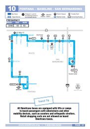
New! System-Wide Transit Corridor Plan for the San ... - Omnitrans
New! System-Wide Transit Corridor Plan for the San ... - Omnitrans
New! System-Wide Transit Corridor Plan for the San ... - Omnitrans

Create successful ePaper yourself
Turn your PDF publications into a flip-book with our unique Google optimized e-Paper software.
Chapter 4<br />
Travel Demand Forecasting and Future<br />
Conditions<br />
This chapter examines <strong>the</strong> future travel markets<br />
in <strong>the</strong> major transit corridors and <strong>the</strong> growth<br />
potential in transit ridership that might be<br />
achieved with <strong>the</strong> introduction of premium transit<br />
service and good connections to o<strong>the</strong>r corridors<br />
and o<strong>the</strong>r operators.<br />
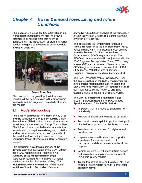
Route 1 Bus at Stop<br />
The examination of growth potential in each<br />
corridor will be demonstrated with demographic<br />
<strong>for</strong>ecasts and <strong>the</strong> projected magnitude of future<br />
trip-making.<br />
4.1 Model Methodology<br />
This section summarizes <strong>the</strong> methodology used<br />
and <strong>the</strong> validation of <strong>the</strong> <strong>San</strong> Bernardino Valley<br />
Focus Model (SBVFM) that was used to produce<br />
travel <strong>for</strong>ecasts <strong>for</strong> <strong>the</strong> Long Range <strong>Transit</strong> <strong>Plan</strong>.<br />
This in<strong>for</strong>mation is intended to demonstrate <strong>the</strong><br />
model’s ability to replicate existing transportation<br />
and transit ridership behavior, and <strong>the</strong> utility of<br />
<strong>the</strong> model <strong>for</strong> <strong>for</strong>ecasting future ridership and<br />
comparing transit alternatives in <strong>San</strong> Bernardino<br />
County.<br />
This document provides a summary of <strong>the</strong><br />
development and derivation of <strong>the</strong> SBVFM from<br />
<strong>the</strong> SCAG regional model, followed by a<br />
summary of <strong>the</strong> model validation ef<strong>for</strong>t<br />
specifically required <strong>for</strong> <strong>the</strong> analysis of transit<br />
services in <strong>the</strong> <strong>San</strong> Bernardino Valley. The<br />
regional nature of <strong>the</strong> remainder of <strong>the</strong> model<br />
(outside of <strong>the</strong> <strong>San</strong> Bernardino Valley) also<br />
allows <strong>for</strong> future transit analysis of <strong>the</strong> remainder<br />
of <strong>San</strong> Bernardino County, to a sketch planning<br />
lower level of accuracy.<br />
The <strong>for</strong>ecasting tool employed <strong>for</strong> <strong>the</strong> Long<br />
Range <strong>Transit</strong> <strong>Plan</strong> is <strong>the</strong> <strong>San</strong> Bernardino Valley<br />
Focus Model, which is a focused model derived<br />
from <strong>the</strong> Sou<strong>the</strong>rn Cali<strong>for</strong>nia Association of<br />
Governments (SCAG) regional model. The<br />
SCAG model was updated in conjunction with <strong>the</strong><br />
2008 Regional Transportation <strong>Plan</strong> (RTP), using<br />
a Year 2003 validation year. Elements of <strong>the</strong><br />
SCAG regional mode are documented in 2003<br />
SCAG Model Validation and Summary –<br />
Regional Transportation Model (January 2008).<br />
The <strong>San</strong> Bernardino Valley Focus Model uses<br />
<strong>the</strong> basic structure of <strong>the</strong> SCAG model, with <strong>the</strong><br />
mode choice model customized <strong>for</strong> use in <strong>the</strong><br />
<strong>San</strong> Bernardino Valley, and an increased level of<br />
definition based on <strong>the</strong> networks and zone<br />
systems found in <strong>the</strong> <strong>San</strong> Bernardino Valley.<br />
The SBVFM employs <strong>the</strong> traditional 4-step<br />
modeling process used in <strong>the</strong> SCAG model.<br />
Special features of <strong>the</strong> SBVFM include:<br />
• All person trips are modeled (including nonmotorized)<br />
• Auto-ownership is tied to transit accessibility<br />
• Person trip data is split into peak and off-peak<br />
trips be<strong>for</strong>e application of distribution models<br />
• Feed-back loops are used <strong>for</strong> highway and<br />
transit skims<br />
• Log-sums are used to estimate composite<br />
impedance <strong>for</strong> application within trip<br />
distribution models <strong>for</strong> home-based work trip<br />
purpose<br />
• Vehicle trip data is split into four time periods<br />
and converted to origin-destination <strong>for</strong>mat<br />
using time-of-day models<br />
• <strong>Transit</strong> trip data is assigned to peak (AM) and<br />
off-peak (midday) time periods in productionattraction<br />
<strong>for</strong>mat<br />
<strong>System</strong>-<strong>Wide</strong> <strong>Transit</strong> <strong>Corridor</strong> <strong>Plan</strong> 73