December 2008 - Halcrow
December 2008 - Halcrow
December 2008 - Halcrow

Create successful ePaper yourself
Turn your PDF publications into a flip-book with our unique Google optimized e-Paper software.
Putting Swindon on the map<br />
<strong>Halcrow</strong> plugs information black hole over Wiltshire<br />
lobal positioning system (GPS)<br />
G<br />
users in the UK are now able to<br />
access more accurate data, thanks<br />
in part to <strong>Halcrow</strong>.<br />
From motorists trading in their dog-eared<br />
maps to surveyors working in the field, more<br />
of us are reliant on GPS than ever before.<br />
While most areas in the UK are within range<br />
of the Ordnance Survey’s continuously<br />
operating reference stations (CORS) network<br />
– OS Net – up until recently an information<br />
‘black hole’ hovered over the Swindon area.<br />
This transmission gap reduced the available<br />
data’s accuracy, prompting Leica Geo-<br />
Systems – one of the world’s leading<br />
equipment manufacturers – to team up with<br />
<strong>Halcrow</strong>’s geospatial skill group.<br />
Resident pigeons at Burderop Park now have<br />
to share the roof space with a CORS. This<br />
installation will provide coverage within the<br />
Leica SmartNet Network, which in turn links<br />
to the OS Net Network.<br />
The benefits for <strong>Halcrow</strong> are manifold. In<br />
addition to free access to data and services<br />
via the station, <strong>Halcrow</strong> will be closely<br />
identified with major improvements to the<br />
network’s capabilities.<br />
Resident pigeons at<br />
Burderop Park now<br />
have to share the roof<br />
space with a CORS<br />
The next step is to incorporate the CORS<br />
into the global navigation satellite system<br />
network, which is tapped into by a diverse<br />
range of academics, surveyors, engineers<br />
and meteorologists. Applications range<br />
from measuring sea level rises to weather<br />
predictions and tracking glacial activity.<br />
The project team of<br />
Simon Canning, Chris Kelly<br />
and Paul Grant<br />
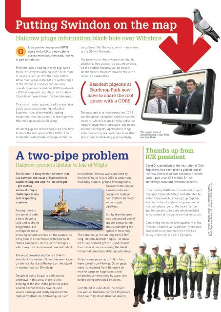
A two-pipe problem<br />
<strong>Halcrow</strong> protects lifeline to Isle of Wight<br />
The Solent – a busy stretch of water that<br />
lies between the coast of Hampshire in<br />
southern England and the Isle of Wight<br />
– presents a<br />
series of unique<br />
challenges to any<br />
self-respecting<br />
engineer.<br />
Among these is<br />
the fact it is both<br />
a busy shipping<br />
lane and yachting<br />
playground, but<br />
perhaps its most<br />
pressing conundrum lies on the seabed. Its<br />
briny floor is crisscrossed with dozens of<br />
cables and pipes – both electric and gas –<br />
with many ‘live’ and several now redundant.<br />
The most crowded section is a 3-4km<br />
stretch of the western Solent between Lepe<br />
on the mainland and Gurnard on the island<br />
in waters that run 25m deep.<br />
Despite it being illegal to both anchor<br />
and trawl in this area, there is little<br />
policing of the law. In the past few years<br />
several anchor strikes have caused<br />
severe damage and costly repairs to the<br />
cable infrastructure. Following just such<br />
Towing the mammoth pipes across the North Sea<br />
an incident, <strong>Halcrow</strong> was appointed by<br />
Southern Water in late 2004 to undertake<br />
feasibility studies, ground investigations,<br />
environmental impact<br />
assessments and<br />
designs to replace<br />
twin 200mm diameter<br />
water supply<br />
pipelines.<br />
But by then the area<br />
was designated one of<br />
special conservation<br />
status, banishing the<br />
option of trenching.<br />
The solution lay in installing twin 3.9kmlong,<br />
300mm-diameter pipes – to allow<br />
for future demand growth – underneath<br />
the conservation zone using the latest<br />
horizontal directional drilling technology.<br />
Polyethylene pipes up to 1.2km long<br />
were towed from Norway. Other pipes<br />
were transported from Denmark by<br />
marine barge on huge spools and<br />
embedded a metre deep by water jets<br />
before being connected by divers.<br />
Completed in June <strong>2008</strong>, the project<br />
has won an Institution of Civil Engineers<br />
(ICE) South East Construction Award.<br />
Thumbs up from<br />
ICE president<br />
David Orr, president of the Institution of Civil<br />
Engineers, has been given a guided tour of<br />
the new 70m lock at east London’s Prescott<br />
Lock – part of an £18 million British<br />
Waterways canal improvement scheme.<br />
Organised by Waltham Cross-based project<br />
manager Tabindah Akhtar and attended by<br />
water and power business group regional<br />
director Roland Grzybek, the presidential<br />
visit included a tour of the lock chamber<br />
and temporary cofferdam, which enabled<br />
construction of the water control structure.<br />
Controlling the water level upstream of the<br />
Prescott Channel will significantly enhance<br />
proposals to regenerate the Lower Lea<br />
Valley in time for the 2012 Olympics.<br />
L to r: Roger Martin, David Orr, Tabindah Akhtar,<br />
Mark Stephens, Roland Grzybek and Colin Perkins