Cell Descriptions - South East Natural Resources Management Board
Cell Descriptions - South East Natural Resources Management Board
Cell Descriptions - South East Natural Resources Management Board
Create successful ePaper yourself
Turn your PDF publications into a flip-book with our unique Google optimized e-Paper software.
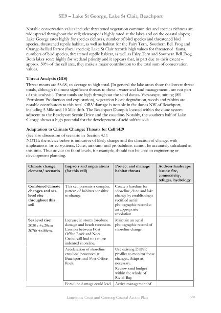
SE9 – Lake St George, Lake St Clair, Beachport<br />
Notable conservation values include: threatened vegetation communities and species richness are<br />
widespread throughout the cell; viewscape is highly rated at the lakes and on the coastal slopes;<br />
Lake George rates highly for species richness, number of bird species and threatened bird<br />
species, threatened reptile habitat, as well as habitat for the Fairy Tern, <strong>South</strong>ern Bell Frog and<br />
Orange-bellied Parrot (focal species); Lake St Clair records high values for threatened fauna,<br />
numbers of bird species, threatened reptile habitat, as well as Fairy Tern and <strong>South</strong>ern Bell Frog.<br />
Both lakes score highly for wetland priority and it appears that, in part due to their extent –<br />
approx. 50% of the cell area, they make a major contribution to the total sum of conservation<br />
values.<br />
Threat Analysis (GIS)<br />
Threat means are 58.68, an average to high total. [In general the lake areas show the lowest threat<br />
totals, although the most significant threats to these - water and land management - are not part<br />
of this analysis]. Threat totals are high throughout the sand dunes. Viewscape, mining (SE<br />
Petroleum Production and exploration), vegetation block degradation, weeds and rabbits are<br />
notable contributors to this total. ORV damage is notable in the dunes NW of Beachport,<br />
including 5 Mile and 10 Mile drift. The Beachport Dump is located within the dune system<br />
adjacent to the Beachport Scenic Drive and the coastline. Notably, the southern half of Lake<br />
George shows a high potential for the development of acid sulfate soils.<br />
Adaptation to Climate Change: Threats for <strong>Cell</strong> SE9<br />
(See also discussion of scenario in Section 4.11<br />
NOTE: the advice below is indicative of likely change and the direction of change, with<br />
implications for ecosystems. Dates, amounts and probabilities cannot be accurately calculated at<br />
this time. Thus advice on flood levels, for example, should not be used in engineering or<br />
development planning.<br />
Climate change<br />
element/ scenario<br />
Combined climate<br />
changes and sea<br />
level rise<br />
throughout this<br />
cell<br />
Sea level rise:<br />
2030 : +c.20cm<br />
2070: +c.80cm.<br />
Impacts and implications Protect and manage Address landscape<br />
(for this cell) habitat threats issues: fire,<br />
connectivity,<br />
refuges, hydrology<br />
This cell presents a complex<br />
pattern of habitats sensitive<br />
to change.<br />
Increase in storm foredune<br />
damage and beach recession.<br />
Erosion between Post<br />
Office Rock and Nora<br />
Creina will lead to a more<br />
indented shoreline.<br />
Acceleration of shoreline<br />
erosional processes at<br />
Beachport and Post Office<br />
Rock.<br />
Foredune damage could lead<br />
Create a baseline for<br />
shoreline, dune and lake<br />
change by establishing a<br />
rectified aerial<br />
photographic record at<br />
an appropriate<br />
resolution.<br />
Maintain an aerial<br />
photographic record of<br />
shoreline change.<br />
Use existing DENR<br />
profiles to monitor these<br />
changes. Adapt as<br />
necessary.<br />
Review sand budget<br />
within the whole of<br />
Rivoli Bay.<br />
Active management of<br />
Limestone Coast and Coorong Coastal Action Plan 350


