- Page 1 and 2: Cell Descriptions 6 Cell descriptio
- Page 3 and 4: SE1 - Piccaninnie Ponds 6.3 Descrip
- Page 5 and 6: SE1 - Piccaninnie Ponds 221 bird sp
- Page 7 and 8: SE1 - Piccaninnie Ponds Listed Abor
- Page 9 and 10: SE1 - Piccaninnie Ponds Climate cha
- Page 11 and 12: SE1 - Piccaninnie Ponds Component I
- Page 13 and 14: SE1 - Piccaninnie Ponds Species Com
- Page 15 and 16: SE1 - Piccaninnie Ponds Species Cas
- Page 17 and 18: SE1 - Piccaninnie Ponds Species Lob
- Page 19 and 20: SE1 - Piccaninnie Ponds Species Com
- Page 21 and 22: SE1 - Piccaninnie Ponds Species Com
- Page 23 and 24: SE1 - Piccaninnie Ponds Species Com
- Page 25: SE1 - Piccaninnie Ponds x: recorded
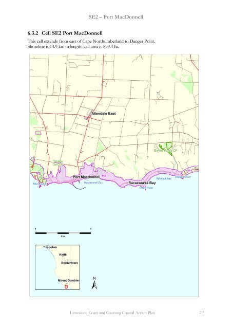
- Page 29 and 30: SE2 - Port MacDonnell The cell also
- Page 31 and 32: SE2 - Port MacDonnell Climate chang
- Page 33 and 34: SE2 - Port MacDonnell Component Iss
- Page 35 and 36: SE2 - Port MacDonnell Species Commo
- Page 37 and 38: SE2 - Port MacDonnell Species Colpo
- Page 39 and 40: SE2 - Port MacDonnell Species Phace
- Page 41 and 42: SE2 - Port MacDonnell Species Commo
- Page 43 and 44: SE2 - Port MacDonnell Species Commo
- Page 45 and 46: SE2 - Port MacDonnell Species Commo
- Page 47 and 48: SE3 - Cape Douglas 6.3.3 Cell SE3 C
- Page 49 and 50: SE3 - Cape Douglas 98% of coastal d
- Page 51 and 52: SE3 - Cape Douglas Climate change e
- Page 53 and 54: SE3 - Cape Douglas Component Issue
- Page 55 and 56: SE3 - Cape Douglas Species Common N
- Page 57 and 58: SE3 - Cape Douglas Species Zygophyl
- Page 59 and 60: SE3 - Cape Douglas Species Common N
- Page 61 and 62: SE3 - Cape Douglas Species Common N
- Page 63 and 64: SE4 - Blackfellows Caves 6.3.4 Cell
- Page 65 and 66: SE4 - Blackfellows Caves shrubland
- Page 67 and 68: SE4 - Blackfellows Caves this time.
- Page 69 and 70: SE4 - Blackfellows Caves Component
- Page 71 and 72: SE4 - Blackfellows Caves BIOTA Flor
- Page 73 and 74: SE4 - Blackfellows Caves Species Lo
- Page 75 and 76: SE4 - Blackfellows Caves Species Co
- Page 77 and 78:
SE4 - Blackfellows Caves Species Co
- Page 79 and 80:
SE4 - Blackfellows Caves Amphibians
- Page 81 and 82:
SE5 - Carpenters Rocks Landforms Th
- Page 83 and 84:
SE5 - Carpenters Rocks Integrate m
- Page 85 and 86:
SE5 - Carpenters Rocks high threats
- Page 87 and 88:
SE5 - Carpenters Rocks Table 6.7. R
- Page 89 and 90:
SE5 - Carpenters Rocks Component Is
- Page 91 and 92:
SE5 - Carpenters Rocks Species Comm
- Page 93 and 94:
SE5 - Carpenters Rocks Species Aust
- Page 95 and 96:
SE5 - Carpenters Rocks Species Lept
- Page 97 and 98:
SE5 - Carpenters Rocks Species Comm
- Page 99 and 100:
SE5 - Carpenters Rocks Species Comm
- Page 101 and 102:
SE5 - Carpenters Rocks Butterflies
- Page 103 and 104:
SE6 - Lake Bonney SE 6.3.6 Cell SE6
- Page 105 and 106:
SE6 - Lake Bonney SE Benthic Habita
- Page 107 and 108:
SE6 - Lake Bonney SE NOTE: the advi
- Page 109 and 110:
SE6 - Lake Bonney SE Component Issu
- Page 111 and 112:
SE6 - Lake Bonney SE Species Common
- Page 113 and 114:
SE6 - Lake Bonney SE Species Oxalis
- Page 115 and 116:
SE6 - Lake Bonney SE Species Common
- Page 117 and 118:
SE6 - Lake Bonney SE Butterflies Sp
- Page 119 and 120:
SE7 - Canunda NP 6.3.7 Cell SE7 Can
- Page 121 and 122:
SE7 - Canunda NP Biota There are 22
- Page 123 and 124:
SE7 - Canunda NP Cell SE7 combined
- Page 125 and 126:
SE7 - Canunda NP Climate change ele
- Page 127 and 128:
SE7 - Canunda NP Component Issue Pr
- Page 129 and 130:
SE7 - Canunda NP Species Common Nam
- Page 131 and 132:
SE7 - Canunda NP Species Hemarthria
- Page 133 and 134:
SE7 - Canunda NP Non-indigenous fau
- Page 135 and 136:
SE7 - Canunda NP Species Common Nam
- Page 137 and 138:
SE7 - Canunda NP Mammals Species Co
- Page 139 and 140:
SE8 - Rivoli Bay 6.3.8 Cell SE8 Riv
- Page 141 and 142:
SE8 - Rivoli Bay Biota There are 7
- Page 143 and 144:
SE8 - Rivoli Bay Climate change ele
- Page 145 and 146:
SE8 - Rivoli Bay Component Issue Pr
- Page 147 and 148:
SE8 - Rivoli Bay Species Common Nam
- Page 149 and 150:
SE8 - Rivoli Bay Species Geranium s
- Page 151 and 152:
SE8 - Rivoli Bay Birds Species Comm
- Page 153 and 154:
SE8 - Rivoli Bay Species Common Nam
- Page 155 and 156:
SE9 - Lake St George, Lake St Clair
- Page 157 and 158:
SE9 - Lake St George, Lake St Clair
- Page 159 and 160:
SE9 - Lake St George, Lake St Clair
- Page 161 and 162:
SE9 - Lake St George, Lake St Clair
- Page 163 and 164:
SE9 - Lake St George, Lake St Clair
- Page 165 and 166:
SE9 - Lake St George, Lake St Clair
- Page 167 and 168:
SE9 - Lake St George, Lake St Clair
- Page 169 and 170:
SE9 - Lake St George, Lake St Clair
- Page 171 and 172:
SE9 - Lake St George, Lake St Clair
- Page 173 and 174:
SE9 - Lake St George, Lake St Clair
- Page 175 and 176:
SE9 - Lake St George, Lake St Clair
- Page 177 and 178:
SE10 - Little Dip CP 6.3.10 Cell SE
- Page 179 and 180:
SE10 - Little Dip CP Benthic Habita
- Page 181 and 182:
SE10 - Little Dip CP Climate change
- Page 183 and 184:
SE10 - Little Dip CP Component Issu
- Page 185 and 186:
SE10 - Little Dip CP Component Issu
- Page 187 and 188:
SE10 - Little Dip CP Species Common
- Page 189 and 190:
SE10 - Little Dip CP Species Common
- Page 191 and 192:
SE10 - Little Dip CP Species Austro
- Page 193 and 194:
SE10 - Little Dip CP Species Codium
- Page 195 and 196:
SE10 - Little Dip CP Species Eucaly
- Page 197 and 198:
SE10 - Little Dip CP Species Impera
- Page 199 and 200:
SE10 - Little Dip CP Species Myriog
- Page 201 and 202:
SE10 - Little Dip CP Species Rhodog
- Page 203 and 204:
SE10 - Little Dip CP Species Wrange
- Page 205 and 206:
SE10 - Little Dip CP Species Common
- Page 207 and 208:
SE10 - Little Dip CP Species Common
- Page 209 and 210:
SE11 - Guichen Bay 6.3.11 Cell SE11
- Page 211 and 212:
SE11 - Guichen Bay Sea Eagle (Halia
- Page 213 and 214:
SE11 - Guichen Bay Climate change e
- Page 215 and 216:
SE11 - Guichen Bay Component Issue
- Page 217 and 218:
SE11 - Guichen Bay Species Crassula
- Page 219 and 220:
SE11 - Guichen Bay Species Common N
- Page 221 and 222:
SE11 - Guichen Bay Species Common N
- Page 223 and 224:
SE12 - Cape Jaffa Landforms This ce
- Page 225 and 226:
SE12 - Cape Jaffa Climate change el
- Page 227 and 228:
SE12 - Cape Jaffa Component Issue P
- Page 229 and 230:
SE12 - Cape Jaffa Species Allocasua
- Page 231 and 232:
SE12 - Cape Jaffa Species Common Na
- Page 233 and 234:
SE12 - Cape Jaffa x: recorded, p: p
- Page 235 and 236:
SE13 - Kingston SE Landforms This c
- Page 237 and 238:
SE13 - Kingston SE and preliminary
- Page 239 and 240:
SE13 - Kingston SE Climate change e
- Page 241 and 242:
SE13 - Kingston SE Component Issue
- Page 243 and 244:
SE13 - Kingston SE Species Apium pr
- Page 245 and 246:
SE13 - Kingston SE Species Picris a
- Page 247 and 248:
SE13 - Kingston SE Species Common N
- Page 249 and 250:
SE13 - Kingston SE Species Common N
- Page 251 and 252:
SE14 - Long Beach Landforms The inl
- Page 253 and 254:
SE14 - Long Beach Climate change el
- Page 255 and 256:
SE14 - Long Beach Component Issue P
- Page 257 and 258:
SE14 - Long Beach Species Carpobrot
- Page 259 and 260:
SE14 - Long Beach Species Common Na
- Page 261 and 262:
SE15-17 - The Coorong Landforms Thi
- Page 263 and 264:
SE15-17 - The Coorong the inner sho
- Page 265 and 266:
SE15-17 - The Coorong the dunes acr
- Page 267 and 268:
SE15-17 - The Coorong Climate chang
- Page 269 and 270:
SE15-17 - The Coorong Component Iss
- Page 271 and 272:
SE15-17 - The Coorong Species Commo
- Page 273 and 274:
SE15-17 - The Coorong Species Commo
- Page 275 and 276:
SE15-17 - The Coorong Species Austr
- Page 277 and 278:
SE15-17 - The Coorong Species Eucal
- Page 279 and 280:
SE15-17 - The Coorong Species Lysia
- Page 281 and 282:
SE15-17 - The Coorong Species Sebae
- Page 283 and 284:
SE15-17 - The Coorong Species Commo
- Page 285 and 286:
SE15-17 - The Coorong Species Commo
- Page 287 and 288:
SE15-17 - The Coorong Species Commo
- Page 289:
SE15-17 - The Coorong Amphibians Sp