

Cell Descriptions - South East Natural Resources Management Board
Cell Descriptions - South East Natural Resources Management Board
Cell Descriptions - South East Natural Resources Management Board

You also want an ePaper? Increase the reach of your titles
YUMPU automatically turns print PDFs into web optimized ePapers that Google loves.
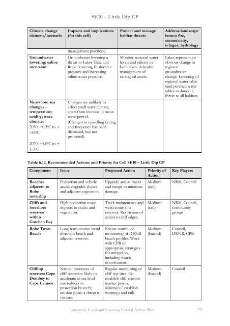
SE10 – Little Dip CP<br />
Climate change<br />
element/ scenario<br />
Groundwater<br />
lowering; saline<br />
incursion:<br />
Nearshore sea<br />
changes -<br />
temperature;<br />
acidity; wave<br />
climate:<br />
2030: +0.3 0 C to +<br />
0.6 0 C<br />
2070: +1.0 0 C to +<br />
1.50C<br />
Impacts and implications Protect and manage Address landscape<br />
(for this cell) habitat threats issues: fire,<br />
connectivity,<br />
refuges, hydrology<br />
management practices).<br />
Groundwater lowering a<br />
threat to Lakes Eliza and<br />
Robe: lowering freshwater<br />
pressure and increasing<br />
saline water pressure.<br />
Changes are unlikely to<br />
affect swell wave climate,<br />
apart from increase in mean<br />
wave period.<br />
(Changes in upwelling timing<br />
and frequency has been<br />
discussed, but not<br />
projected).<br />
Monitor seasonal water<br />
levels and salinity in<br />
both lakes. Adaptive<br />
management of<br />
ecological assets.<br />
Lakes represent an<br />
obvious change in<br />
regional<br />
groundwater<br />
change. Lowering of<br />
regional water table<br />
(and perched water<br />
tables in dunes) a<br />
threat to all habitats.<br />
Table 6.12. Recommended Actions and Priority for <strong>Cell</strong> SE10 – Little Dip CP<br />
Component Issue Proposed Action Priority of Key Players<br />
Action<br />
Beaches<br />
adjacent to<br />
Robe<br />
township<br />
Cliffs and<br />
foreshore<br />
reserves<br />
within<br />
Guichen Bay<br />
Robe Town<br />
Beach<br />
Clifftop<br />
reserves: Cape<br />
Dombey to<br />
Cape Lannes<br />
Pedestrian and vehicle<br />
access degrades slopes<br />
and adjacent vegetation.<br />
High pedestrian usage<br />
impacts to tracks and<br />
vegetation.<br />
Long term erosive trend<br />
threatens beach and<br />
adjacent reserves.<br />
<strong>Natural</strong> processes of<br />
cliff recession likely to<br />
accelerate as sea level<br />
rise reduces to<br />
protection by reefs;<br />
erosion poses a threat to<br />
visitors.<br />
Upgrade access tracks<br />
and ramps to minimise<br />
damage.<br />
Track maintenance and<br />
weed control in<br />
reserves. Restriction of<br />
access to cliff edges.<br />
Ensure continued<br />
monitoring of DENR<br />
beach profiles. Work<br />
with CPB on<br />
appropriate strategies<br />
for mitigation,<br />
including beach<br />
nourishment.<br />
Regular monitoring of<br />
cliff top sites. Reestablish<br />
cliff erosion<br />
marker points.<br />
Maintain / establish<br />
warnings and rails.<br />
Medium.<br />
(cell)<br />
Medium.<br />
(cell)<br />
Medium<br />
(hazard)<br />
Medium.<br />
(hazard)<br />
NRM, Council<br />
NRM, Council,<br />
community<br />
groups<br />
Council,<br />
DENR, CPB<br />
Council<br />
Limestone Coast and Coorong Coastal Action Plan 374


