

13.2 The Wallis Lake Estuary Management Committee - Great Lakes ...
13.2 The Wallis Lake Estuary Management Committee - Great Lakes ...
13.2 The Wallis Lake Estuary Management Committee - Great Lakes ...

Create successful ePaper yourself
Turn your PDF publications into a flip-book with our unique Google optimized e-Paper software.
<strong>Wallis</strong> <strong>Lake</strong> <strong>Estuary</strong> <strong>Management</strong> Plan<br />
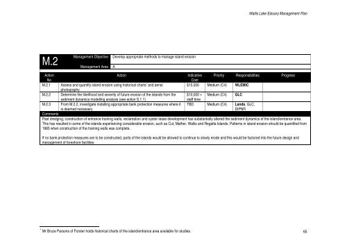
M.2<br />
<strong>Management</strong> Area A<br />
<strong>Management</strong> Objective<br />
Develop appropriate methods to manage island erosion<br />
Action<br />
No<br />
M.2.1<br />
M.2.2<br />
M.2.3<br />
Action<br />
Assess and quantify island erosion using historical charts * and aerial<br />
photography<br />
Determine the likelihood and severity of future erosion of the islands from the<br />
sediment dynamics modelling analysis (see action S.1.1)<br />
From M.2.2, investigate installing appropriate bank protection measures where it<br />
is deemed necessary<br />
Indicative Priority Responsibilities Progress<br />
Cost<br />
$15,000 Medium (C4) WLEMIC<br />
$10,000 +<br />
staff time<br />
Medium (C4) GLC<br />
TBD Medium (C4) Lands, GLC,<br />
DIPNR<br />
Comments<br />
Past dredging, construction of entrance training walls, reclamation and oyster lease development has substantially altered the sediment dynamics of the island/entrance area.<br />
This has resulted in some of the islands experiencing considerable erosion, such as Cut, Mather, <strong>Wallis</strong> and Regatta Islands. Patterns in island erosion should be quantified from<br />
1965 when construction of the training walls was complete.<br />
If no bank protection measures are to be constructed, parts of the islands would be allowed to continue to slowly erode and this would be factored into the future design and<br />
management of foreshore facilities.<br />
* Mr Bruce Parsons of Forster holds historical charts of the island/entrance area available for studies.<br />
65


