Web Document Design and access statement - Southwark Council ...
Web Document Design and access statement - Southwark Council ...
Web Document Design and access statement - Southwark Council ...

Create successful ePaper yourself
Turn your PDF publications into a flip-book with our unique Google optimized e-Paper software.
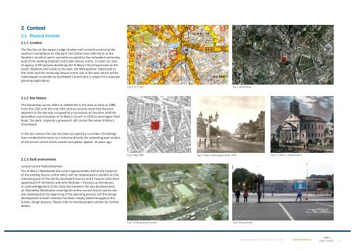
2 Context<br />
2.1 Physical Context<br />
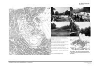
2.1.1 Location<br />
The Site lies on the western edge of what until recently used to be the<br />
southern roundabout on Elephant <strong>and</strong> Castle (now referred to as the<br />
Southern Junction) <strong>and</strong> is currently occupied by the redundant swimming<br />
pool of the existing Elephant <strong>and</strong> Castle leisure centre. It covers an area<br />
of approx. 0.56 hectares bordering the St Mary’s Churchyard park to the<br />
south, Elephant <strong>and</strong> Castle to the east, the Metropolitan Tabernacle to<br />
the north <strong>and</strong> the remaining leisure centre site to the west which will be<br />
redeveloped in parallel by <strong>Southwark</strong> <strong>Council</strong> (but is subject to a separate<br />
planning application).<br />
Fig. 2: A-Z map<br />
Fig 3: Aerial View<br />
2.1.2 Site History<br />
The Doomsday survey refers to settlement in the area as early as 1086.<br />
From the 12th until the mid 19th century records show that the park<br />
adjacent to the Site was occupied by a succession of churches until the<br />
demolition <strong>and</strong> relocation of St Mary’s Church in 1876 to Kennington Park<br />
Road. The park, originally a graveyard, still carries the name St Mary’s<br />
Churchyard.<br />
In the last century the Site has been occupied by a number of buildings<br />
from residential terraces to a school <strong>and</strong> lastly the swimming pool section<br />
of the leisure centre which ceased occupation approx. 14 years ago.<br />
2.1.3 Built environment<br />
Fig 4: Map 1850<br />
Fig 5: Photo of Newington Butts 1870<br />
Fig 6: St Mary’s of Newington<br />
Leisure Centre Redevelopment<br />
The St Mary’s Residential site covers approximately half of the footprint<br />
of the existing leisure centre which will be redeveloped in parallel on the<br />
remaining part of the site by <strong>Southwark</strong> <strong>Council</strong> <strong>and</strong> 4 Futures (who have<br />
appointed S+P Architects <strong>and</strong> John McAslan + Partners as Architects).<br />
In acknowledgement of the close ties between the two developments<br />
an Illustrative Masterplan covering the entire current leisure centre site<br />
was developed at the beginning of the planning process <strong>and</strong> the design<br />
development of both schemes has been closely linked throughout the<br />
further design process. Please refer to the Masterplan section for further<br />
details.<br />
leisure<br />
centre<br />
swimming<br />
pool<br />
Fig 7: Existing leisure centre<br />
Fig 8: Disused pool<br />
St Mary’s Residential Detailed Planning Application June 2012<br />
6
Existing buildings on site<br />
The redundant swimming pool (which has been closed due to structural<br />
problems for many years) <strong>and</strong> current leisure centre are both very<br />
introverted buildings with few windows to provide any street animation<br />
or natural surveillance. The external elevations are extremely uniform <strong>and</strong><br />
blank <strong>and</strong> rely solely on signage to advertise the internal building use <strong>and</strong><br />
entrance position (which is hard to locate).<br />
Fig. 9: Strata Tower by BFLS<br />
Fig. 10: Elephant <strong>and</strong> Castle shopping centre - Existing<br />
Fig. 11: St Modwen Shopping centre redevelopment - concept image<br />
Immediate Surroundings<br />
The immediate surroundings of the Site are extremely diverse <strong>and</strong> mixed.<br />
The former churchyard to the south (now a park) is the only visible public<br />
green space <strong>and</strong> a well used community meeting point with playgrounds<br />
for different ages, outdoor seating <strong>and</strong> a small skate boarder community.<br />
The green space st<strong>and</strong>s in stark contrast to the adjacent busy Southern<br />
Junction. The Metropolitan Tabernacle to the north of the Site is the<br />
only pre-war development along Elephant <strong>and</strong> Castle. Together with the<br />
adjacent London College of Communication it creates a clear boundary<br />
between the commercial character of Elephant <strong>and</strong> Castle <strong>and</strong> the<br />
residential areas to the west known as Elliots Row. Opposite the site the<br />
Elephant <strong>and</strong> Castle shopping centre, which was the first covered shopping<br />
mall in Europe, awaits redevelopment.<br />
Fig. 12: 360 London<br />
by Rogers Stirk Harbour & Partners<br />
Adjoining tall buildings<br />
The existing buildings along Elephant <strong>and</strong> Castle are generally higher than<br />
those on the surrounding side streets though most fall within the mid<br />
rise bracket. However recent developments show a shift towards greater<br />
height.<br />
The recently completed Strata tower on Walworth Road to the south of the<br />
site designed by BFLS (formerly Hamiltons) houses 408 apartments in 43<br />
storeys (147.9m above AOD).<br />
It is flanked by the 25 storey Draper House, a brutalist towerblock from<br />
1965 which was at the time of its completion the highest residential<br />
building in London.<br />
To the south west of the site, planning consent has been obtained for the<br />
‘360’ (also known as the former London Park Hotel) development designed<br />
by Rogers Stirk Harbour <strong>and</strong> Partners, which is to house 470 apartments in<br />
a tower rising to 44 storeys (146.6m above AOD) <strong>and</strong> some associated mid<br />
rise buildings.<br />
In addition Oakmayne Plaza designed by Tate Hindle to the north east of<br />
the site (which is currently under construction) will consist of three blocks<br />
up to 26 storeys high (87.5m above AOD).<br />
A further planning application for a tall building nearby (Eileen House<br />
designed by Allies <strong>and</strong> Morrison, a 44 storey high tower (134m above AOD)<br />
to the North of the tube station) is currently awaiting determination by the<br />
Mayor of London.<br />
An outline planning application for the Heygate Masterplan designed by<br />
Make also identifies a number of locations for future high rise buildings.<br />
Fig 13: Oakmayne Plaza by Tate Hindle<br />
Fig 14: Existing <strong>and</strong> proposed high rise buildings around the site<br />
Background paper: Urban design Revision 1, March 2012<br />
St Mary’s Residential Detailed Planning Application June 2012<br />
7
2.1.4 Elephant <strong>and</strong> Castle Regeneration<br />
The Elephant <strong>and</strong> Castle Opportunity Area has been identified in the<br />
<strong>Southwark</strong> Plan as an area with potential for substantial change to<br />
transform the wider area. Key components of the Opportunity Area include<br />
the redevelopment of the following areas:<br />
nn<br />
The existing leisure centre site<br />
nn<br />
The housing estates on Phase 1 of the Heygate Regeneration <strong>and</strong> the<br />
Heygate Masterplan<br />
nn<br />
The Elephant <strong>and</strong> Castle shopping centre<br />
The Site lies within the central area of the Elephant <strong>and</strong> Castle Opportunity<br />
Area in a zone that has been identified in the background paper on<br />
urban design for the Elephant <strong>and</strong> Castle Opportunity Area, the Draft<br />
Supplementary Planning <strong>Document</strong> (SPD) <strong>and</strong> Opportunity Area Planning<br />
Framework (OAPF), to support intense development (subject to compliance<br />
with <strong>Southwark</strong>’s Plan Policy 3.20 which sets out criteria regarding the<br />
specific location of tall buildings, including that tall buildings should be<br />
located at a point of l<strong>and</strong>mark significance <strong>and</strong> contribute positively to<br />
the skyline as a whole while consolidating in clusters within a skyline, or<br />
providing key focus within views).<br />
In fact one of the options of the OAPF for tall buildings in the opportunity<br />
area tested in the background paper (option 3) indicates a tall building on<br />
the site (see Figure 18).<br />
Fig. 15: The E&C Opportunity Area<br />
Fig. 16: Character areas in the E&C Opportunity Area<br />
KEY:<br />
Lend Lease:<br />
1 Heygate (outline)<br />
2. Phase One (Rodney Road)<br />
Fig. 17: Planned developments in Elephant <strong>and</strong> Castle<br />
The main items listed for consideration in the character assessment of the<br />
central area in the OAPF are<br />
nn<br />
Impact on the local context (such as adjacent conservation areas <strong>and</strong><br />
heritage assets in the local <strong>and</strong> wider area);<br />
nn<br />
Impact on the strategic view from Serpentine Bridge towards Palace<br />
of Westminster World Heritage Site, especially for any tall buildings<br />
proposals;<br />
3.St Mary’s Residential<br />
<strong>Southwark</strong> <strong>Council</strong>:<br />
4. Leisure Centre<br />
5. E&C Opportunity Area SPD<br />
St Modwen<br />
6. Shopping Centre<br />
Both of these items have been considered from the early stages of the<br />
design as outlined in the following chapters.<br />
Fig. 18: Testing Option 3 - Urban <strong>Design</strong> Background Paper<br />
Fig. 19: Planning application programmes<br />
Fig. 20: Model - Heygate Masterplan designed by Make<br />
Fig. 21: Heygate Masterplan by Make - March 2012<br />
St Mary’s Residential Detailed Planning Application June 2012<br />
8