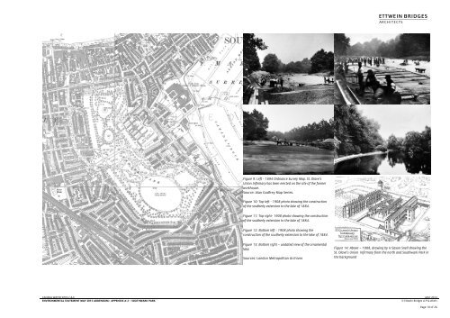
Figure 9: Left - 1894 Ordnance Survey Map. St. Olave's Union ...
Figure 9: Left - 1894 Ordnance Survey Map. St. Olave's Union ...
Figure 9: Left - 1894 Ordnance Survey Map. St. Olave's Union ...

You also want an ePaper? Increase the reach of your titles
YUMPU automatically turns print PDFs into web optimized ePapers that Google loves.
A<strong>Figure</strong> 15: 1914 <strong>Ordnance</strong> <strong>Survey</strong> <strong>Map</strong>.Source: Alan Godfrey <strong>Map</strong> Series.<strong>Figure</strong> 16: Aerial photograph dated 1926 looking west over the northern half of Southwark Park. The Infirmary towers would have been quiteprominent on the skyline when viewed from the east/west carriageway dividing the park in half.Source: Alan Godfrey <strong>Map</strong> Series.CANADA WATER SITES C & E MAY 2013ENVIRONMENTAL STATEMENT MAY 2013 ADDENDUM:- APPENDIX A-2 – SOUTHWARK PARK © Ettwein Bridges LLP & othersPage 11 of 26
A<strong>Figure</strong> 17: 1940’s LCC Bomb Damage map showing the extent of damage wreaked on this part of Southwark during the blitz on London. The darker colours represent the most severely damaged buildings and the entire east side of thePark around the Infirmary suffered direct hits by both V1 flying bombs and V2 long range rockets. The map only records damage to structures and seems to suggest that the park survived the blitz unscathed. However, the park would have suffered some damage due tothe indiscriminate nature and extent of the bombing aimed at the docks, warehouses and transport infrastructure.Source: London Metropolitan ArchivesCANADA WATER SITES C & E MAY 2013ENVIRONMENTAL STATEMENT MAY 2013 ADDENDUM:- APPENDIX A-2 – SOUTHWARK PARK © Ettwein Bridges LLP & othersPage 12 of 26
A<strong>Figure</strong> 18: Owing the damage caused by the Second World War and the decline of the docks, the LCC envisagedmassive redevelopment of almost the whole of Bermondsey between Old Kent Road and the river and the riversideextension of Southwark Park. The plan above shows a theoretical layout of the land bordering the west side ofSouthwark Park showing predominantly residential blocks of varying heights rising at the perimeter edge to 8-10storeys overlooking the park and riverside.Source: County of London Plan 1943 – Abercrombie & Forshaw<strong>Figure</strong> 19: An illustration dated 1943 showing the proposals described opposite.Source: County of London Plan 1943 – Abercrombie & ForshawCANADA WATER SITES C & E MAY 2013ENVIRONMENTAL STATEMENT MAY 2013 ADDENDUM:- APPENDIX A-2 – SOUTHWARK PARK © Ettwein Bridges LLP & othersPage 13 of 26
A<strong>Figure</strong> 20: A plan dated 1943 showing another set of proposals for the redevelopment of Bermondsey west of Southwark Park. The park itself is shown extending to the riverside and the newmajo road is shown running east west along the northern edge of the park. Both the riverside park extension and the A200 road and roundabout have been constructed over the last 50 years,though not entirely as shown.Source: County of London Plan 1943 – Abercrombie & ForshawCANADA WATER SITES C & E MAY 2013ENVIRONMENTAL STATEMENT MAY 2013 ADDENDUM:- APPENDIX A-2 – SOUTHWARK PARK © Ettwein Bridges LLP & othersPage 14 of 26