Figure 9: Left - 1894 Ordnance Survey Map. St. Olave's Union ...
Figure 9: Left - 1894 Ordnance Survey Map. St. Olave's Union ...
Figure 9: Left - 1894 Ordnance Survey Map. St. Olave's Union ...

Create successful ePaper yourself
Turn your PDF publications into a flip-book with our unique Google optimized e-Paper software.
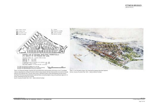
A<strong>Figure</strong> 18: Owing the damage caused by the Second World War and the decline of the docks, the LCC envisagedmassive redevelopment of almost the whole of Bermondsey between Old Kent Road and the river and the riversideextension of Southwark Park. The plan above shows a theoretical layout of the land bordering the west side ofSouthwark Park showing predominantly residential blocks of varying heights rising at the perimeter edge to 8-10storeys overlooking the park and riverside.Source: County of London Plan 1943 – Abercrombie & Forshaw<strong>Figure</strong> 19: An illustration dated 1943 showing the proposals described opposite.Source: County of London Plan 1943 – Abercrombie & ForshawCANADA WATER SITES C & E MAY 2013ENVIRONMENTAL STATEMENT MAY 2013 ADDENDUM:- APPENDIX A-2 – SOUTHWARK PARK © Ettwein Bridges LLP & othersPage 13 of 26