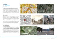
Figure 9: Left - 1894 Ordnance Survey Map. St. Olave's Union ...
Figure 9: Left - 1894 Ordnance Survey Map. St. Olave's Union ...
Figure 9: Left - 1894 Ordnance Survey Map. St. Olave's Union ...

Create successful ePaper yourself
Turn your PDF publications into a flip-book with our unique Google optimized e-Paper software.
A<strong>Figure</strong> 17: 1940’s LCC Bomb Damage map showing the extent of damage wreaked on this part of Southwark during the blitz on London. The darker colours represent the most severely damaged buildings and the entire east side of thePark around the Infirmary suffered direct hits by both V1 flying bombs and V2 long range rockets. The map only records damage to structures and seems to suggest that the park survived the blitz unscathed. However, the park would have suffered some damage due tothe indiscriminate nature and extent of the bombing aimed at the docks, warehouses and transport infrastructure.Source: London Metropolitan ArchivesCANADA WATER SITES C & E MAY 2013ENVIRONMENTAL STATEMENT MAY 2013 ADDENDUM:- APPENDIX A-2 – SOUTHWARK PARK © Ettwein Bridges LLP & othersPage 12 of 26