Figure 9: Left - 1894 Ordnance Survey Map. St. Olave's Union ...
Figure 9: Left - 1894 Ordnance Survey Map. St. Olave's Union ...
Figure 9: Left - 1894 Ordnance Survey Map. St. Olave's Union ...

You also want an ePaper? Increase the reach of your titles
YUMPU automatically turns print PDFs into web optimized ePapers that Google loves.
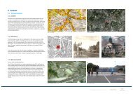
A<strong>Figure</strong> 20: A plan dated 1943 showing another set of proposals for the redevelopment of Bermondsey west of Southwark Park. The park itself is shown extending to the riverside and the newmajo road is shown running east west along the northern edge of the park. Both the riverside park extension and the A200 road and roundabout have been constructed over the last 50 years,though not entirely as shown.Source: County of London Plan 1943 – Abercrombie & ForshawCANADA WATER SITES C & E MAY 2013ENVIRONMENTAL STATEMENT MAY 2013 ADDENDUM:- APPENDIX A-2 – SOUTHWARK PARK © Ettwein Bridges LLP & othersPage 14 of 26