Natural Resources Chapter of the Master Plan - Town of Wolfeboro
Natural Resources Chapter of the Master Plan - Town of Wolfeboro
Natural Resources Chapter of the Master Plan - Town of Wolfeboro

You also want an ePaper? Increase the reach of your titles
YUMPU automatically turns print PDFs into web optimized ePapers that Google loves.
<strong>Natural</strong> <strong>Resources</strong> <strong>Chapter</strong>, <strong>Wolfeboro</strong>, NH<br />
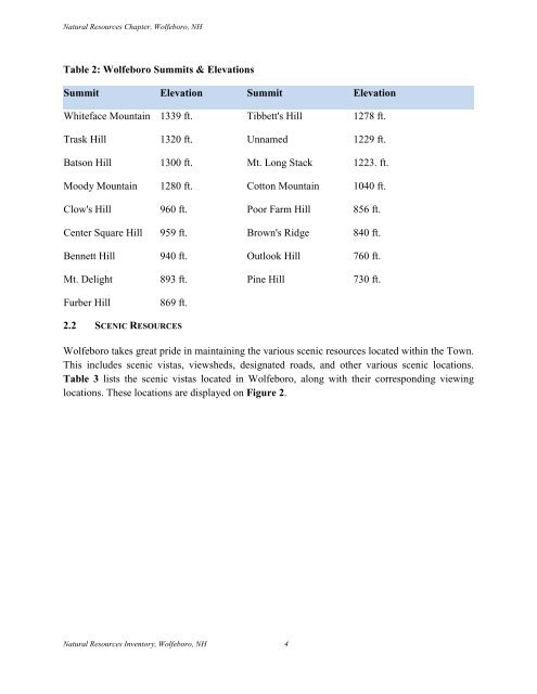
Table 2: <strong>Wolfeboro</strong> Summits & Elevations<br />
Summit Elevation Summit Elevation<br />
Whiteface Mountain 1339 ft. Tibbett's Hill 1278 ft.<br />
Trask Hill 1320 ft. Unnamed 1229 ft.<br />
Batson Hill 1300 ft. Mt. Long Stack 1223. ft.<br />
Moody Mountain 1280 ft. Cotton Mountain 1040 ft.<br />
Clow's Hill 960 ft. Poor Farm Hill 856 ft.<br />
Center Square Hill 959 ft. Brown's Ridge 840 ft.<br />
Bennett Hill 940 ft. Outlook Hill 760 ft.<br />
Mt. Delight 893 ft. Pine Hill 730 ft.<br />
Furber Hill<br />
869 ft.<br />
2.2 SCENIC RESOURCES<br />
<strong>Wolfeboro</strong> takes great pride in maintaining <strong>the</strong> various scenic resources located within <strong>the</strong> <strong>Town</strong>.<br />
This includes scenic vistas, viewsheds, designated roads, and o<strong>the</strong>r various scenic locations.<br />
Table 3 lists <strong>the</strong> scenic vistas located in <strong>Wolfeboro</strong>, along with <strong>the</strong>ir corresponding viewing<br />
locations. These locations are displayed on Figure 2.<br />
<strong>Natural</strong> <strong>Resources</strong> Inventory, <strong>Wolfeboro</strong>, NH 4