Natural Resources Chapter of the Master Plan - Town of Wolfeboro
Natural Resources Chapter of the Master Plan - Town of Wolfeboro
Natural Resources Chapter of the Master Plan - Town of Wolfeboro

You also want an ePaper? Increase the reach of your titles
YUMPU automatically turns print PDFs into web optimized ePapers that Google loves.
<strong>Natural</strong> <strong>Resources</strong> <strong>Chapter</strong>, <strong>Wolfeboro</strong>, NH<br />
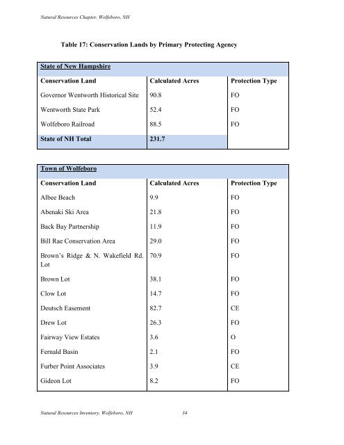
Table 17: Conservation Lands by Primary Protecting Agency<br />
State <strong>of</strong> New Hampshire<br />
Conservation Land Calculated Acres Protection Type<br />
Governor Wentworth Historical Site 90.8 FO<br />
Wentworth State Park 52.4 FO<br />
<strong>Wolfeboro</strong> Railroad 88.5 FO<br />
State <strong>of</strong> NH Total 231.7<br />
<strong>Town</strong> <strong>of</strong> <strong>Wolfeboro</strong><br />
Conservation Land Calculated Acres Protection Type<br />
Albee Beach 9.9 FO<br />
Abenaki Ski Area 21.8 FO<br />
Back Bay Partnership 11.9 FO<br />
Bill Rae Conservation Area 29.0 FO<br />
Brown‟s Ridge & N. Wakefield Rd.<br />
Lot<br />
70.9 FO<br />
Brown Lot 38.1 FO<br />
Clow Lot 14.7 FO<br />
Deutsch Easement 82.7 CE<br />
Drew Lot 26.3 FO<br />
Fairway View Estates 3.6 O<br />
Fernald Basin 2.1 FO<br />
Furber Point Associates 3.9 CE<br />
Gideon Lot 8.2 FO<br />
<strong>Natural</strong> <strong>Resources</strong> Inventory, <strong>Wolfeboro</strong>, NH 34