Natural Resources Chapter of the Master Plan - Town of Wolfeboro
Natural Resources Chapter of the Master Plan - Town of Wolfeboro
Natural Resources Chapter of the Master Plan - Town of Wolfeboro

Create successful ePaper yourself
Turn your PDF publications into a flip-book with our unique Google optimized e-Paper software.
<strong>Natural</strong> <strong>Resources</strong> <strong>Chapter</strong>, <strong>Wolfeboro</strong>, NH<br />
Porcupine Brook<br />
The Porcupine Brook drainage is a series <strong>of</strong> large isolated wetlands located in <strong>the</strong> nor<strong>the</strong>astern<br />
portion <strong>of</strong> <strong>Wolfeboro</strong>. This drainage and <strong>the</strong> Young‟s Brook drainage are <strong>the</strong> only two drainages<br />
in <strong>Wolfeboro</strong> serving <strong>the</strong> Saco River Basin. The remote character, rich flora and fauna, historical<br />
past, aes<strong>the</strong>tics, and recreational opportunities <strong>of</strong> this wetland complex are key reasons for<br />
designating this wetland(s) as prime.<br />
Ryefield Brook<br />
This complex consists <strong>of</strong> a series <strong>of</strong> wetland areas which in total compromise one <strong>of</strong> <strong>the</strong> richest<br />
and most diverse habitats in <strong>Wolfeboro</strong>. Its location as <strong>the</strong> major tributary to <strong>the</strong> north <strong>of</strong> Lake<br />
Wentworth gives this wetland complex an important significance. In total, <strong>the</strong> hydrologic, flora<br />
and fauna, food chain productivity, historic importance and high level <strong>of</strong> aes<strong>the</strong>tic, recreational<br />
and educational value are key considerations in designating this wetland as prime.<br />
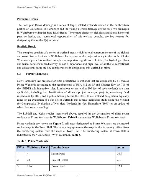
5.3 PRIME WETLANDS<br />
New Hampshire law provides for extra protections to wetlands that are designated by a <strong>Town</strong> as<br />
Prime Wetlands according to <strong>the</strong> requirements <strong>of</strong> RSA 482-A: 15 and <strong>Chapter</strong> Env-Wt 700 <strong>of</strong><br />
<strong>the</strong> NHDES administrative rules. Limitations to use within 100 feet <strong>of</strong> such wetlands are <strong>the</strong>n<br />
applicable, including <strong>the</strong> classification <strong>of</strong> all such project as major projects, mandatory field<br />
inspections by DES, and a public hearing before <strong>the</strong> DES. Prime wetland designation typically<br />
relies on an evaluation <strong>of</strong> a sub-set <strong>of</strong> wetlands that receive individual study using <strong>the</strong> Method<br />
for Comparative Evaluation <strong>of</strong> Non-tidal Wetlands in New Hampshire (1991) or an update <strong>of</strong><br />
which is currently pending.<br />
The Lobdell and Keith studies mentioned above, resulted in <strong>the</strong> designation <strong>of</strong> thirty-seven<br />
wetlands as Prime Wetlands in <strong>Wolfeboro</strong>. Table 8 summarizes <strong>Wolfeboro</strong>‟s Prime Wetlands.<br />
Prime wetlands are shown on Figure 7. All areas designated as Prime Wetlands are delineated<br />
on file maps in <strong>the</strong> <strong>Town</strong> Hall. The numbering system on <strong>the</strong> maps in this inventory differs from<br />
<strong>the</strong> numbering system from <strong>the</strong> maps at <strong>Town</strong> Hall. The numbering system at <strong>Town</strong> Hall is<br />
indicated by <strong>the</strong> “<strong>Wolfeboro</strong> PW #” column in Table 8.<br />
Table 8: Prime Wetlands<br />
PW # <strong>Wolfeboro</strong> PW # Complex Name Acres<br />
1 4 Batson Pond 30.9<br />
2 20 Clay Pit Brook 2.3<br />
3 21A Clows Brook 12.1<br />
<strong>Natural</strong> <strong>Resources</strong> Inventory, <strong>Wolfeboro</strong>, NH 15