Natural Resources Chapter of the Master Plan - Town of Wolfeboro
Natural Resources Chapter of the Master Plan - Town of Wolfeboro
Natural Resources Chapter of the Master Plan - Town of Wolfeboro
You also want an ePaper? Increase the reach of your titles
YUMPU automatically turns print PDFs into web optimized ePapers that Google loves.
<strong>Natural</strong> <strong>Resources</strong> <strong>Chapter</strong>, <strong>Wolfeboro</strong>, NH<br />
5.1 NATIONAL WETLANDS INVENTORY<br />
The US Fish & Wildlife Service has completed a National Wetland Inventory (NWI) for <strong>the</strong><br />
entire country. The NWI classifies all wetlands and deepwater habitats according to “The<br />
Methodology for <strong>the</strong> Classification <strong>of</strong> Wetlands and Deepwater Habitats”, Cowardin et al, 1979.<br />
Per <strong>the</strong> Cowardin methodology, all wetlands belong to one <strong>of</strong> five major wetland Systems:<br />
Lacustrine (lakes and ponds); Riverine (rivers and streams); Marine (deep water saltwater<br />
environments); Estuarine (shallow tidal influenced saltwater wetlands) and Palustrine<br />
(everything else such as marshes, swamps, shallow ponds, etc). Within each System, Classes and<br />
Sub-Classes fur<strong>the</strong>r subdivide wetlands according to common attributes. Each individual mapped<br />
wetland was assigned a code representing its System, Class and Subclass.<br />
Figure 7 shows <strong>the</strong> distribution <strong>of</strong> NWI wetlands as mapped by <strong>the</strong> USFWS within <strong>the</strong> <strong>Town</strong> <strong>of</strong><br />
<strong>Wolfeboro</strong>. Lacustrine, Riverine and Palustrine wetlands all occur in <strong>Wolfeboro</strong>. Approximately<br />
1,425 acres <strong>of</strong> <strong>the</strong> <strong>Town</strong> are mapped as Palustrine wetlands. Lacustrine wetlands (lakes and<br />
ponds) are described in more detail in Section 5.0. Palustrine wetlands as mapped by <strong>the</strong> NWI<br />
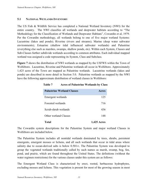
have <strong>the</strong> following approximate distribution <strong>of</strong> wetland classes in <strong>Wolfeboro</strong>:<br />
Table 7<br />
Acres <strong>of</strong> Palustrine Wetlands by Class<br />
Palustrine Wetland Classes<br />
Acres<br />
Emergent wetlands 125<br />
Forested wetlands 716<br />
Scrub-shrub wetlands 436<br />
O<strong>the</strong>r wetland Classes 148<br />
Total<br />
1,425 Acres<br />
The Cowardin system descriptions for <strong>the</strong> Palustrine System and major wetland Classes in<br />
<strong>Wolfeboro</strong> are included below.<br />
The Palustrine System includes all nontidal wetlands dominated by trees, shrubs, persistent<br />
emergents, emergent mosses or lichens, and all such wetlands that occur in tidal areas where<br />
salinity due to ocean-derived salts is below 0.501∞. The Palustrine System was developed to<br />
group <strong>the</strong> vegetated wetlands traditionally called by such names as marsh, swamp, bog, fen,<br />
pond, and prairie, which are found throughout <strong>the</strong> United States. The definitions (without <strong>the</strong><br />
water regimen restrictions) for <strong>the</strong> various classes under this system are as follows:<br />
The Emergent Wetland Class is characterized by erect, rooted, herbaceous hydrophytes,<br />
excluding mosses and lichens. This vegetation is present for most <strong>of</strong> <strong>the</strong> growing season in most<br />
<strong>Natural</strong> <strong>Resources</strong> Inventory, <strong>Wolfeboro</strong>, NH 13


