Assessment Practices Review Panel - St. Louis County
Assessment Practices Review Panel - St. Louis County
Assessment Practices Review Panel - St. Louis County

You also want an ePaper? Increase the reach of your titles
YUMPU automatically turns print PDFs into web optimized ePapers that Google loves.
3.6 Use of technology & innovation of practices<br />
3.6.1 Description of findings<br />
Technology changes will impact work processes and organization<br />
- A gap in technology use and access exists between county assessor staff and some<br />
local assessors. This has an impact on uniformity of assessment practices and the<br />
ability by local assessors to effectively work on countywide systems.<br />
- There is discussion on which CAMA system is appropriate to enter assessment<br />
information.<br />
- Technology changes such as the integration of permitting systems with GIS and<br />
satellite imagery analysis may reduce the number of physical inspections required,<br />
change work processes and increase staff productivity. These implications will need to<br />
be taken into account in strategic planning for the county assessment process.<br />
- Property owners will in the near future be able to review property information on the<br />
<strong>County</strong> website.<br />
3.6.2 Analysis<br />
There is a gap between the county, which is progressive in maintaining up to date<br />
computer systems, and some local assessors, who have more limited resources and<br />
smaller economies of scale to maintain the same technology standard. These technology<br />
challenges include access to bandwidth, system compatibility and computer knowledge of<br />
assessors. Within the current mixed system this warrants a discussion identifying<br />
technology options and appropriateness of technology for countywide application.<br />
The current Computer Assisted Mass Appraisal (CAMA) system is used to record<br />
assessment data. It is not considered user-friendly by the local assessors. Concerns<br />
include difficulty accessing the system, difficulty remembering all the coding, etc., if you<br />
do not use the system every day, and not being able to run other applications while in the<br />
CAMA system through its VPN connection.<br />
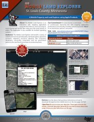
The <strong>St</strong>. <strong>Louis</strong> <strong>County</strong> Geographic Information System (GIS) offers technology tools for<br />
the assessment process that were not available in the past. GIS is a system designed to<br />
capture, store, manipulate, analyze, manage, and map large quantities of geospatial data<br />
and non-geospatial data, for example, linking property information with permit data and<br />
monitoring changes using satellite imagery. Full utilization of GIS capabilities will be an<br />
important tool in the property assessment process and will change work processes. The<br />
documentation found in Appendix VII (Existing and Emerging Technology for the<br />
<strong>Assessment</strong> Process) provides examples of how technology can be utilized.<br />
The anticipated technology changes and implications for optimal organizational structure<br />
and staffing need to be taken into account in long term planning. Also important in<br />
implementing technology changes is the regulatory environment under which the<br />
<strong>St</strong>. <strong>Louis</strong> <strong>County</strong> <strong>Assessment</strong> <strong>Practices</strong> <strong>Review</strong> <strong>Panel</strong> Draft Report February 2012 Page 27