Assessment Practices Review Panel - St. Louis County
Assessment Practices Review Panel - St. Louis County
Assessment Practices Review Panel - St. Louis County

You also want an ePaper? Increase the reach of your titles
YUMPU automatically turns print PDFs into web optimized ePapers that Google loves.
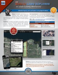
12'<br />
12'<br />
Legend<br />
Planimetric Boundary Lines<br />
Planimetric Polygons<br />
INFORMATION<br />
APEX<br />
CAMA<br />
PROPERTY CARDS<br />
AERIAL PICTOMETRY<br />
12'<br />
4'<br />
OPEN PORCH<br />
20' 80'<br />
20'<br />
4'<br />
35'<br />
RES 1-3<br />
1040'<br />
19'<br />
BASE GAR<br />
529'<br />
23'<br />
STORAGE<br />
36'<br />
6'<br />
GAZEBO<br />
236.6'<br />
7'<br />
12'<br />
2.8'<br />
14'<br />
DECKING<br />
220.8'<br />
6'<br />
2.9'<br />
10'<br />
3.9'<br />
12'<br />
11'<br />
RES 1-3<br />
18'<br />
RES 1-3<br />
228'<br />
19'<br />
12'<br />
12'<br />
OPEN PORCH<br />
4' 48'<br />
20'<br />
14'<br />
STORAGE<br />
280'<br />
14'<br />
20'<br />
28'<br />
3'<br />
12'<br />
24'<br />
BASE GAR<br />
672'<br />
24'<br />
RES 1-3<br />
324'<br />
27'<br />
4'<br />
8'<br />
17'<br />
3'<br />
12'<br />
5.5'<br />
8'<br />
18'<br />
DECKING<br />
332.1'<br />
DECKING<br />
64'<br />
18'<br />
5.1'<br />
RES 1-3<br />
1280'<br />
8'<br />
14'<br />
2'<br />
RES 1-3<br />
40'<br />
20'<br />
20'<br />
12'<br />
17'<br />
16'<br />
2'<br />
14'<br />
24'<br />
RES 1-3<br />
48'<br />
18'<br />
N<br />
10'<br />
10'<br />
2'<br />
4'<br />
6'<br />
12'<br />
DECKING<br />
336'<br />
7.2'<br />
10'<br />
8'<br />
8'<br />
STORAGE<br />
96'<br />
Prepared By:<br />
Map Created: 05/22/2009<br />
Planning & Development<br />
Planning, Research, & GIS Division<br />
(218) 725-5000<br />
www.co.st-louis.mn.us<br />
Location: M:\00 PRAGIS\Projects\Current Projects\Enterprise Data Development<br />
Source: <strong>St</strong>. <strong>Louis</strong> <strong>County</strong><br />
Disclaimer<br />
This is a compilation of records as they<br />
appear in the <strong>St</strong>. <strong>Louis</strong> <strong>County</strong> Offices<br />
affecting the area shown. This drawing<br />
is to be used only for reference purposes<br />
and the <strong>County</strong> is not responsible for any<br />
inaccuracies herein contained.<br />
© Copyright <strong>St</strong>. <strong>Louis</strong> <strong>County</strong> All Rights Reserved<br />
Assessor's <strong>St</strong>ructures (Planimetric) Data<br />
Enterprise Data Development<br />
0 5 10 20 30 40 50 60<br />
Feet