Assessment Practices Review Panel - St. Louis County
Assessment Practices Review Panel - St. Louis County
Assessment Practices Review Panel - St. Louis County

You also want an ePaper? Increase the reach of your titles
YUMPU automatically turns print PDFs into web optimized ePapers that Google loves.
Public Records & Property Valuation: Recorder<br />
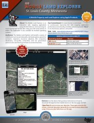
MT IRON ECONOMIC<br />
DEVELOPMENT AUTH<br />
MT IRON ECONOMIC<br />
DEVELOPMENT<br />
AUTH<br />
MT IRON ECONOMIC<br />
DEVELOPMENT AUTH<br />
NORTHWARD<br />
PROPERTIES LLC<br />
NORTHWARD PROPERTIES LLC<br />
Private Individual<br />
(Nikolanci)<br />
CITY OF MT IRON<br />
MESSIAH LUTHERAN CHURCH MT IRON<br />
175-0070-01430<br />
175-0071-00870<br />
HRA OF<br />
MT IRON<br />
HOUSING &<br />
REDEVELOPMENTPrivate Individual<br />
AUTHORITY (Johnson)<br />
HOUSING &<br />
REDEVELOPMENT<br />
AUTHORITY<br />
Private Individual<br />
(Roskoski)<br />
175-0071-01550<br />
175-0071-01582<br />
•<br />
Improves <strong>Review</strong> Processes<br />
Currently, when examining documents, the Recorder’s Office in many<br />
Prepared By: Planning & Development Disclaimer<br />
instances Planning, must Research, access maps & GIS and Division data This in is other a compilation departments of records to as complete they appear in the Saint<br />
(218) 725-5000<br />
a review and determination of a document. <strong>Louis</strong> <strong>County</strong> This Offices method affecting slows the down area shown. the This drawing<br />
www.co.st-louis.mn.us<br />
is to be used only for reference purposes and the <strong>County</strong> is not<br />
Team Credits:<br />
process<br />
Planning,<br />
and ties<br />
Land,<br />
up staff<br />
PW, 911<br />
in several departments. responsible for any For inaccuracies example: herein the Examiner<br />
contained.<br />
Source: of Titles <strong>St</strong>. and <strong>Louis</strong> the <strong>County</strong>, Recorder’s DNR staff must review maps from scattered sources<br />
© Copyright <strong>St</strong>. <strong>Louis</strong> <strong>County</strong> All Rights Reserved<br />
Map Created: when examining 3/24/2008 and reviewing documents. Often they must physically<br />
•<br />
N<br />
Assists Cleaning-Up Parcels with Clouded Property Titles<br />
Many developments are well down the road of securing private and public<br />
dollars, permits, and bids only to hit an obstacle of a clouded property title.<br />
Title problems can be expensive, cause delays, or kill a project. There are key<br />
parcels in Duluth and 0 other communities 0.05 0.1that remain undeveloped in part<br />
because clearing the title can be cumbersome, and the city or developer is<br />
Miles<br />
unwilling to take on the responsibility of clearing title.<br />
go to the Auditor’s Tax Department or call the <strong>County</strong> Surveyor’s office,<br />
causing additional staff workload in all departments. With GIS, Recorder’s<br />
• Improves Service and Efficiency<br />
staff can internally review documents, saving time for both Mountain departments.<br />
Quick Drill Down- Improves Ability to <strong>Review</strong> Documents<br />
Iron, MN<br />
Quickly/Easily:<br />
GIS will dramatically improve the ability of Recorder’s staff, businesses,<br />
• Assists in Certificate of Title Determination School District (ISD 703, 712) and residents surrounding to quickly area search, ownership<br />
locate, and review a wide range of legal<br />
A review of GIS will assist Recorder’s staff in assessing the need for a residue documents. Currently, there is no ability for searches by address, which<br />
certificate of title as part of a transaction.<br />
causes problems (additional research) of locating the correct documents<br />
filed on a particular property.<br />
• Enhances Business Interaction<br />
Improves Response Time to Data Requests: The Recorder’s Office receives<br />
Identifies Exact Location of Cellular Phone Callers<br />
innumerable phone calls, e-mails and written requests from people looking<br />
The Recorder’s Office records documents and creates certificates that<br />
for objective data such as lot size, recording data of documents, whether<br />
many businesses seek for its normal business transactions. These<br />
Torrens or Abstract, and the existence of liens or encumbrances. With GIS,<br />
businesses are title companies or attorneys doing title searches, abstracts,<br />
recorded documents and data can be quickly searched and located, thus<br />
owners and encumbrance reports, title insurance, and much more. With<br />
reducing the amount of time for each request.<br />
GIS, a business can quickly query and locate a person or property (by<br />
address, legal description or clicking on property– the latter of which • Web Portal: Enhances Access 24/7<br />
currently does not exist), and begin the review process. This improves the A web site using a parcel map that allows the internet user to drill down<br />
efficiency of the businesses and reduces the amount of time county staff<br />
to the parcel level to find such information would significantly reduce<br />
spends helping businesses locate a site.<br />
employee time devoted to such mundane data gathering.<br />
<strong>St</strong>. <strong>Louis</strong> <strong>County</strong>, Minnesota 10 <strong>County</strong> GIS Use