Assessment Practices Review Panel - St. Louis County
Assessment Practices Review Panel - St. Louis County
Assessment Practices Review Panel - St. Louis County

You also want an ePaper? Increase the reach of your titles
YUMPU automatically turns print PDFs into web optimized ePapers that Google loves.
!<br />
17'<br />
!<br />
! !<br />
22'<br />
29'<br />
7'<br />
2'<br />
12'<br />
6'<br />
22'<br />
8'<br />
8' 3' 10'<br />
3'<br />
10'<br />
4'<br />
1'<br />
20'<br />
10'<br />
7'<br />
19.7'<br />
2'<br />
12'<br />
4'<br />
13<br />
12'<br />
2'<br />
3'<br />
26'<br />
6'<br />
4'<br />
14.7'<br />
16'<br />
23'<br />
25'<br />
25'<br />
10'<br />
26'<br />
Public Records & Property Valuation: Assessor<br />
ALDER AVE<br />
3780 ALDER AVENUE<br />
5151 COUNTRY ROAD<br />
395-0064-00080<br />
395-0064-00110<br />
5141 COUNTRY ROAD<br />
COUNTRY RD<br />
395-0064-00100<br />
395-0062-00080<br />
s<br />
ndary Lines<br />
ns<br />
395-0064-00070<br />
UTM: 4813835,3341995<br />
395-0064-00100<br />
UTM: 4814124,3341971<br />
395-0062-00080<br />
UTM: 4814329,3341955<br />
RDS<br />
METRY<br />
395-0064-00070<br />
DEDICATED ROW<br />
DEDICATED ROW<br />
5160 COUNTRY ROAD<br />
395-0064-00010<br />
UTM: 4814212,3341911<br />
COUNTRY LN<br />
395-0064-00060<br />
5156 COUNTRY ROAD<br />
395-0066-00050<br />
5161 COUNTRY LANE<br />
395-0064-00010<br />
395-0062-00150<br />
395-0064-00090<br />
5173 COUNTRY LANE<br />
395-0064-00060<br />
UTM: 4813992,3341706<br />
395-0064-00020<br />
UTM: 4814062,3341705<br />
395-0064-00020<br />
N<br />
Development<br />
rch, & GIS Division<br />
n.us<br />
nt Projects\Addressing <strong>St</strong>andards<br />
Disclaimer<br />
This is a compilation of records as they<br />
appear in the <strong>St</strong>. <strong>Louis</strong> <strong>County</strong> Offices<br />
affecting the area shown. This drawing<br />
is to be used only for reference purposes<br />
and the <strong>County</strong> is not responsible for any<br />
inaccuracies herein contained.<br />
© Copyright <strong>St</strong>. <strong>Louis</strong> <strong>County</strong> All Rights Reserved<br />
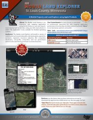
Addressing: Residential <strong>St</strong>ructure & Driveway<br />
DK<br />
486'<br />
0 5 10 20 30 40 50 60 70 80 90 100 110<br />
Enterprise Data Development<br />
2.8'<br />
1/C<br />
15.8'<br />
2.8'<br />
1/C<br />
24'<br />
7.5'<br />
1/B<br />
354'<br />
Feet<br />
2/B<br />
1073'<br />
AG/F<br />
650'<br />
OP<br />
12'<br />
3' 7'<br />
2.8'<br />
1/C<br />
11.9'<br />
SOO<br />
40'<br />
1/C<br />
11.9'<br />
2.8'<br />
•<br />
•<br />
•<br />
Fair and Equitable <strong>Assessment</strong><br />
A parcel map would help both county and local assessors to locate parcels<br />
from various points of view that affect value and classification. Such points<br />
of view include location with regard to access (roads, water, trails); location<br />
with regard to man-made features both good (parks, malls, hospitals,<br />
schools) and unpleasant (active gravel pits, junkyards); location with regard<br />
to natural features both good (lakes, rivers, panoramic views) and bad<br />
(erosion areas, low lands subject to seasonal flooding); location with regard<br />
to market trends (changes in demographics, investment opportunities); and<br />
location with regard to legal use (zoning laws, habitat restrictions).<br />
Improves Real Estate Record Analysis<br />
The Assessor’s Office receives innumerable amounts of data requests from<br />
real estate professionals researching information on comparable sales,<br />
acreage, bath and bedroom counts, assessments, taxes, land values, price<br />
per acres, and a host of other facts. Such data requests have made the<br />
Assessor’s staff de facto research assistants. GIS will substantially reduce the<br />
number of these requests.<br />
Improves <strong>Assessment</strong> Tracking and Analysis<br />
Improves Sales Trend Trackings: GIS is being used more and more to<br />
display such sales trends as price paid per acre or front footage, depreciation<br />
of existing buildings as markets heat up or cool off, effects of recent changes<br />
in legal use on a market, influx of out-of-county buyers, conversion of parcels<br />
from one use to another. Such displays can be used by assessors to write<br />
valuation schedules and by taxpayers to judge the reasonableness of their<br />
57<br />
•<br />
market values and the reasons behind increases/decreases.<br />
Provides Ability to Match Undocumented New Construction &<br />
<strong>St</strong>ructures to a Parcel: An appraiser who comes across undocumented<br />
structures, or first-time new construction, can use the GIS parcel layer to<br />
identify the parcel and its owner.<br />
2/B<br />
1199'<br />
DK<br />
264'<br />
Improves Auditing <strong>Assessment</strong><br />
Enhances Administration Functions: GIS can be used to display such sales<br />
trends as price paid per acre or front footage, depreciation of existing sales.<br />
Provides Equalization Support: Parcel maps can display assessed values<br />
of parcels side-by-side throughout a neighborhood, township, or region.<br />
Assessors can compare, for instance, the consistency of their estimated<br />
market values on contiguous 40-acre parcels, or platted lots.<br />
Assists Board of Appeal and Equalization: GIS helps the Appeal Board<br />
members to “get their bearings” as taxpayers come in one at a time and<br />
appeal the value/class on a particular parcel. GIS maps would help the<br />
board make judgements with regard to locale, neighboring influences.<br />
• Improves Service and Efficiency<br />
Improves Response Time to Data Requests: GIS data is linked through<br />
a web portal to reduce information requests by phone calls, walk-in, and<br />
e-mail questions regarding basic assessment data. A web site using a<br />
parcel map allows the internet user to drill down to the parcel level to find<br />
such information and compare properties. This would significantly reduce<br />
employee time devoted to data gathering.<br />
<strong>St</strong>. <strong>Louis</strong> <strong>County</strong>, Minnesota 9 <strong>County</strong> GIS Use