

subsurface geology and coal resources of the pennsylvanian system ...
subsurface geology and coal resources of the pennsylvanian system ...
subsurface geology and coal resources of the pennsylvanian system ...

You also want an ePaper? Increase the reach of your titles
YUMPU automatically turns print PDFs into web optimized ePapers that Google loves.
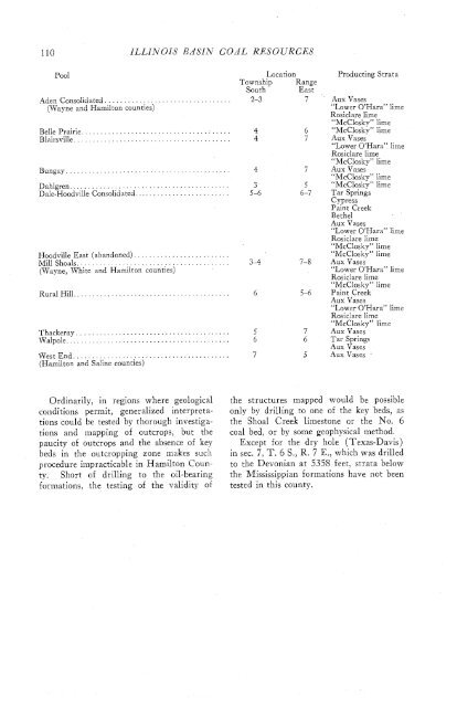
110 ILLINOIS BASIN COAL RESOURCES<br />
Pool<br />
Location<br />
Township Range<br />
South East<br />
Aden Consolidated. ................................ 2-3 7<br />
(Wayne <strong>and</strong> Hamilton counties)<br />
Belle Prairie. ...................................... 4 6<br />
Blairsville ......................................... 4 7<br />
Bungay ........................................... 4 7<br />
Dahlgren. ......................................... 3 5<br />
D ale-Hoodville Consolidated. ........................ 5-6 6-7<br />
Hoodville East (ab<strong>and</strong>oned).........................<br />
Millshoals ........................................<br />
(Wayne, White <strong>and</strong> Hamilton counties)<br />
3-4 7-8<br />
Rural Hill.. ....................................... 6 5-6<br />
Thackeray ........................................ 5 7<br />
W alpole. .......................................... 6 6<br />
West End ......................................... 7 5<br />
(Hamilton <strong>and</strong> Saline counties)<br />
Producting Strata<br />
Aux Vases<br />
"Lower O'Hara" lime<br />
Rosiclare lime<br />
"McClosky" lime<br />
"McClosky" lime<br />
Aux Vases<br />
"Lower O'Hara" lime<br />
Rosiclare lime<br />
"McClosky" lime<br />
Aux Vases<br />
"McClosky" lime<br />
"McClosky" lime<br />
Tar Springs<br />
Cypress<br />
Paint Creek<br />
Be<strong>the</strong>l<br />
Aux Vases<br />
"Lower O'Hara" lime<br />
Rosiclare lime<br />
"McClosky" lime<br />
"McClosky" lime<br />
Aux Vases<br />
"Lower O'Hara" lime<br />
Rosiclare lime<br />
"McClosky" lime<br />
Paint Creek<br />
Aux Vases<br />
"Lower O'Hara" lime<br />
Rosiclare lime<br />
"McClosky" lime<br />
Aux Vases<br />
Tar Springs<br />
Aux Vases<br />
Aux Vases *<br />
Ordinarily, in regions where geological<br />
conditions permit, generalized interpretations<br />
could be tested by thorough investigations<br />
<strong>and</strong> mapping <strong>of</strong> outcrops, but <strong>the</strong><br />
paucity <strong>of</strong> outcrops <strong>and</strong> <strong>the</strong> absence <strong>of</strong> key<br />
beds in <strong>the</strong> outcropping zone makes silch<br />
procedure impracticable in Hamilton County.<br />
Short <strong>of</strong> drilling to <strong>the</strong> oil-bearing<br />
formations, <strong>the</strong> testing <strong>of</strong> <strong>the</strong> validity <strong>of</strong><br />
<strong>the</strong> structures mapped would be possible<br />
only by drilling to one <strong>of</strong> <strong>the</strong> key beds, as<br />
<strong>the</strong> Sho,al Creek limestone or <strong>the</strong> No. 6<br />
<strong>coal</strong> bed, or by some geophysical method.<br />
Except for <strong>the</strong> dry hole (Texas-Davis)<br />
in sec. 7, T. 6 S., R. 7 E., which was drilled<br />
to <strong>the</strong> Devonian at 5358 feet, strata below<br />
<strong>the</strong> Mississippian formations have not been<br />
tested in this county.


