

subsurface geology and coal resources of the pennsylvanian system ...
subsurface geology and coal resources of the pennsylvanian system ...
subsurface geology and coal resources of the pennsylvanian system ...

You also want an ePaper? Increase the reach of your titles
YUMPU automatically turns print PDFs into web optimized ePapers that Google loves.
LEGEND<br />
LlUESTONE /____/ BLACK SLATE AN3<br />
SHALE<br />
BLACK SHALE<br />
/ 55r\NDSTOhE COAL<br />
a CALCAREOUS<br />
UNDERCLAY<br />
SAND<br />
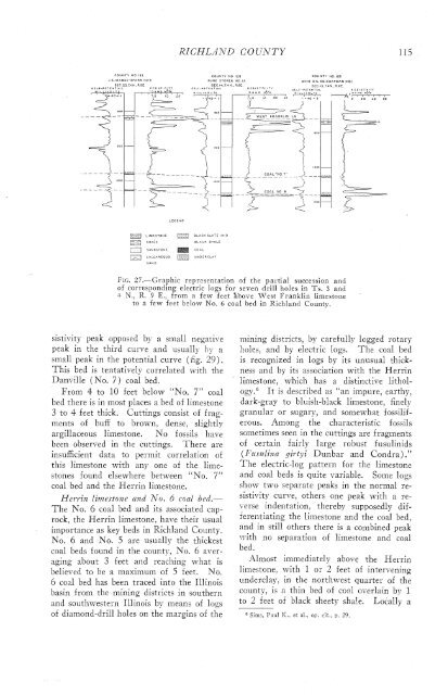
Fit. 27.-Graphic representation <strong>of</strong> <strong>the</strong> partial succession <strong>and</strong><br />
<strong>of</strong> corresponding electric logs for seven drill holes in Ts. 3 <strong>and</strong><br />
-F N., R. 9 E., from a few feet "aove West Franklin limestone<br />
to a few feet below No. 6 <strong>coal</strong> bed in Richl<strong>and</strong> County.<br />
sistivity peak opposed by a small negative<br />
peak in <strong>the</strong> thisd curve <strong>and</strong> usually !;- n<br />
small peak in <strong>the</strong> potential curve (fig. 29).<br />
This bed is tentatively correlated with <strong>the</strong><br />
Danville (No. 7) <strong>coal</strong> bed.<br />
From 4 to 10 feet below "No. 7" <strong>coal</strong><br />
bed <strong>the</strong>re is in most places a bed <strong>of</strong> limestone<br />
3 to 4 feet thick. Cuttings consist <strong>of</strong> fragments<br />
<strong>of</strong> buff to brown, dense, slightly<br />
argillaceous limestone. No fossils have<br />
been o,bserved in <strong>the</strong> cuttings.<br />
There are<br />
insufficient data to permit correlation <strong>of</strong><br />
this limestone with any one <strong>of</strong> <strong>the</strong> limestones<br />
found elsewhere between "No. 7"<br />
<strong>coal</strong> bed <strong>and</strong> <strong>the</strong> Herrin limestone.<br />
Merrin limestone <strong>and</strong> No. 6 <strong>coal</strong> bed.-<br />
The No. 6 <strong>coal</strong> bed <strong>and</strong> its associated caprock,<br />
<strong>the</strong> Heri-in limestone, have <strong>the</strong>ir usual<br />
importance as key beds in Richl<strong>and</strong> County.<br />
No. 6 <strong>and</strong> No. 5 are usually <strong>the</strong> thickest<br />
<strong>coal</strong> beds found in <strong>the</strong> county, No. 6 aver-<br />
aging about 3 feet <strong>and</strong> reaching what is<br />
believed to be a maximum <strong>of</strong> 5 feet. No.<br />
6 <strong>coal</strong> bed has been traced into <strong>the</strong> Illinois<br />
basin from <strong>the</strong> mining districts in sou<strong>the</strong>rn<br />
<strong>and</strong> southwestern Illinois by means <strong>of</strong> logs<br />
<strong>of</strong> diamond-drill holes on <strong>the</strong> margins <strong>of</strong> <strong>the</strong><br />
mining districts, by carefully logged sotasy<br />
holes, <strong>and</strong> by electric logs. The <strong>coal</strong> bed<br />
is recognized in logs by its unusual thickness<br />
<strong>and</strong> by its association with <strong>the</strong> Merrin<br />
limestone, which has a distinctive lithol-<br />
~gy.~ It is described as "an impure, earthy,<br />
dark-gray to bluish-black limestone, finely<br />
granular or sugary, <strong>and</strong> somewhat fossiliferous.<br />
Among <strong>the</strong> characteristic fossils<br />
sometimes seen in <strong>the</strong> cuttings are fragments<br />
<strong>of</strong> certain fairly large robust fusulinids<br />
(I;'usulina gil-tyi Dunbar <strong>and</strong> Condra) ."<br />
The electric-log pattern for <strong>the</strong> limestone<br />
<strong>and</strong> <strong>coal</strong> beds is quite variable. Some logs<br />
show two separate peaks in <strong>the</strong> normal resistivity<br />
curve, o<strong>the</strong>rs one peak with a reverse<br />
indentation, <strong>the</strong>reby supposedly diflerentiating<br />
<strong>the</strong> limestone <strong>and</strong> <strong>the</strong> <strong>coal</strong> bed,<br />
<strong>and</strong> in still o<strong>the</strong>rs <strong>the</strong>re is a combined peak<br />
:zith no separation <strong>of</strong> limestone <strong>and</strong> <strong>coal</strong><br />
bed.<br />
Almost immediately above <strong>the</strong> Herrin<br />
Limestone, with 1 or 2 feet <strong>of</strong> intervening<br />
underclay, in <strong>the</strong> northwest quarter <strong>of</strong> <strong>the</strong><br />
county, is a thin bed <strong>of</strong> cod overlain by 1<br />
to 2 feet <strong>of</strong> black sheety shale. Locally a<br />
Sims, Paul IT., et al., op. cit., p. 29.


