

subsurface geology and coal resources of the pennsylvanian system ...
subsurface geology and coal resources of the pennsylvanian system ...
subsurface geology and coal resources of the pennsylvanian system ...

Create successful ePaper yourself
Turn your PDF publications into a flip-book with our unique Google optimized e-Paper software.
HAMILTON COUNTY<br />
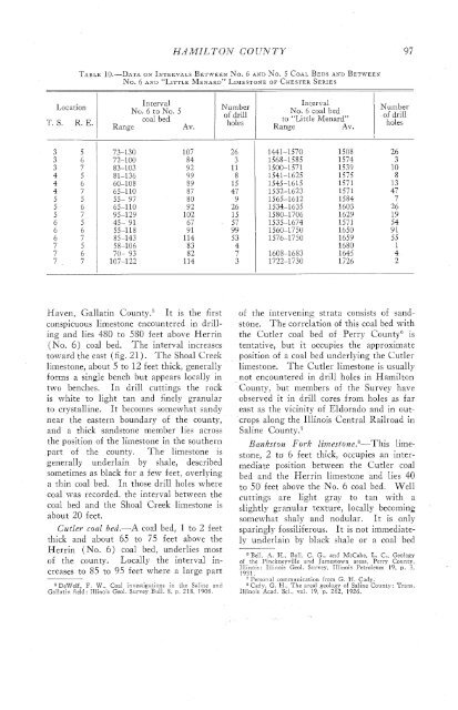
TABLE 10.-DATA ON INTERVALS BETWEENO. 6 AND NO. 5 COAL BEDS AND BETWEEN<br />
No. 6 AND "LITTLE MENARD" LIMESTONE OF CHESTER SERIES<br />
Location<br />
T. S. R. E.<br />
Interval<br />
No. 5 to No. 5<br />
<strong>coal</strong> bed<br />
Range<br />
Av.<br />
Number<br />
<strong>of</strong> drill<br />
holes<br />
Interval<br />
No. 6 <strong>coal</strong> bed<br />
to "Little Menard"<br />
Range<br />
Av.<br />
Number<br />
<strong>of</strong> drill<br />
holes<br />
Haven, Gallatin County:' It is <strong>the</strong> first<br />
conspicuous limestone encountered in drilling<br />
<strong>and</strong> lies 480 to 580 feet above Herrin<br />
(No. 6) <strong>coal</strong> bed. The interval increases<br />
toward <strong>the</strong> east (fig. 21). The Shoal Creek<br />
limestone, about 5 to 12 feet thick, generally<br />
forms a single bench but appears locally in<br />
two benches. In drill cuttings <strong>the</strong> rock<br />
is white to light tan <strong>and</strong> finely granular<br />
to crystalline. It becomes somewhat s<strong>and</strong>y<br />
near <strong>the</strong> eastern boundary <strong>of</strong> <strong>the</strong> county,<br />
<strong>and</strong> a thick s<strong>and</strong>stone member lies across<br />
<strong>the</strong> position <strong>of</strong> <strong>the</strong> limestone in <strong>the</strong> sou<strong>the</strong>rn<br />
part <strong>of</strong> <strong>the</strong> county. The limestone is<br />
generally underlain by shale, described<br />
sometimes as black for a few feet, overlying<br />
a thin <strong>coal</strong> bed. In those drill hclcs where<br />
<strong>coal</strong> was recorded, <strong>the</strong> interval between <strong>the</strong><br />
<strong>coal</strong> bed <strong>and</strong> <strong>the</strong> Shoal Creek limestone is<br />
about 20 feet.<br />
Cutler <strong>coal</strong> bed.-A <strong>coal</strong> bed, 1 to 2 feet<br />
thick <strong>and</strong> about 65 to 75 feet above <strong>the</strong><br />
Herrin (No. 6) <strong>coal</strong> bed, underlies most<br />
<strong>of</strong> <strong>the</strong> county. Locally <strong>the</strong> interval increases<br />
to $5 to 95 feet where a large part<br />
5 DeWolf, F. W.. Coal investigations in <strong>the</strong> Saline <strong>and</strong><br />
Gallatin field: Illinois Geol. Survey Bull. 5. p. 218, 1905<br />
<strong>of</strong> <strong>the</strong> intervening strata consists <strong>of</strong> s<strong>and</strong>stone.<br />
The correlation <strong>of</strong> this <strong>coal</strong> bed with<br />
<strong>the</strong> Cutler <strong>coal</strong> bed <strong>of</strong> Perry CountyG is<br />
tentative, but it occupies <strong>the</strong> approximate<br />
position <strong>of</strong> a <strong>coal</strong> bed underlying <strong>the</strong> Cutler<br />
limestone. The Cutler limestone is usually<br />
not encountered in drill holes in Hamilton<br />
County, but members <strong>of</strong> <strong>the</strong> Survey have<br />
observed it in drill cores from holes as far<br />
east as <strong>the</strong> vicinity <strong>of</strong> Eldorado <strong>and</strong> in outcrops<br />
along <strong>the</strong> Illinois Central Railroad in<br />
Saline C~unty.~<br />
Bankst on Fork 1ime~tone.~-This limestone,<br />
2 to 6 feet thick, occupies an intermediate<br />
position between <strong>the</strong> Cutler <strong>coal</strong><br />
bed <strong>and</strong> <strong>the</strong> Herrin limestone <strong>and</strong> lies 40<br />
to 50 feet above <strong>the</strong> No. 6 <strong>coal</strong> bed. Well<br />
cuttings are light gray to tan with a<br />
slightly granular texture, locally becoming<br />
somewhat shaly <strong>and</strong> nodular. It is only<br />
sparingly fossiliferous. It is not immediately<br />
underlain by black shale or a <strong>coal</strong> bed<br />
F13ell, A. Il., Ball, C. G., <strong>and</strong> McCabe, L. C., Geology<br />
<strong>of</strong> <strong>the</strong> Pinckneyville <strong>and</strong> Jarnestown areas, Perry County,<br />
Illinois: Illinois Geol. Survcy, Illinois Petroleum 19, p. 3,<br />
1931.<br />
Personal communication from G. H. Cady.<br />
Cady, G. H.. The areal <strong>geology</strong> <strong>of</strong> Saline County: Trans.<br />
Illinois Acad. Sci., vol. 19, p. 262, 1926.


