- Page 1 and 2: SUBSURFACE GEOLOGY AND COAL RESOURC
- Page 3 and 4: ORGANIZATION STATE OF ILLINOIS HON.
- Page 5 and 6: CONTENTS INTRODUCTION BY GILBERT H
- Page 7 and 8: PAGE Structure of Herrin (No. 6) co
- Page 11 and 12: SUBSURFACE GEOLOGY AND COAL RESOURC
- Page 13 and 14: oi the strata below the lower bench
- Page 15 and 16: INTRODUCTION 13 less than 1000 feet
- Page 17 and 18: INTRODUCTION 15 Grateful acknowledg
- Page 19 and 20: INTRODUCTION TABLE 2.-CONTROL DRILL
- Page 21 and 22: INTRODUCTION i I County Sec. T. R.
- Page 23 and 24: Cumberland County 585 725 731 1130
- Page 25 and 26: Jasper County Siltstone 11 ; black
- Page 27: Sangamon County Wabash County 467 "
- Page 30 and 31: 28 ILLINOIS BASIN COAL RESO UKCES t
- Page 32 and 33: 30 ILLINOIS BASIN COAL RESOURCES 1
- Page 34 and 35: 32 ILLINOIS BASIAT COAL RESOURCES t
- Page 36 and 37: 34 ILLINOIS BASIN C09L RESOURCES la
- Page 38 and 39: 36 ILLINOIS BASIN COAL RESOURCES gr
- Page 40 and 41: 3 5 ILLINOIS BASIN COAL RESOURCES 1
- Page 42 and 43: 40 ILLINOIS BASIN COAL RESOURCES be
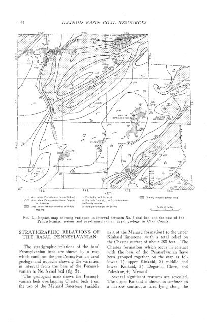
- Page 44 and 45: 42 ILLINOIS BASIAT COAL RESOURCES W
- Page 48 and 49: 46 ILLINOIS BASIN COAL RESOURCES qu
- Page 50 and 51: ILLINOIS BASIN COAL RESOURCES TABLE
- Page 52 and 53: 50 ILLINOIS BASIN COAL RESOURCES Lo
- Page 54 and 55: ILLINOIS BASIN COAL RESOURCES 34 I
- Page 56 and 57: ILLINOIS BASIN COAL RESOURCES EDWAR
- Page 58 and 59: TABLE 6.-INTERVALS BETWEEN TOP OF N
- Page 60 and 61: 58 ILLINOIS BASIAT COAL RESOURCES H
- Page 62 and 63: 60 ILLINOIS BASIN COAL RESOURCES li
- Page 64 and 65: 62 ILLINOIS BASIN COAL RESOURCES th
- Page 66 and 67: ILLINOIS BASIN COAL RESOURCES
- Page 68 and 69: ILLINOIS BASIN COAL RESOURCES TABLE
- Page 70 and 71: 68 ILLINOIS BASIlV COAL RESOURCES t
- Page 72 and 73: 70 ILLINOIS BASIN COAL RESOURCES as
- Page 74 and 75: ILLIxOIS BASIN COAL RESOURCES
- Page 76 and 77: 7 4 ILLINOIS KASIAT COAL RESOURCES
- Page 78 and 79: ILLIATOIS BASIN COAL RESO URCES GAR
- Page 80 and 81: ILLILVOPS iZASIA7 COAL RESOURCES
- Page 82 and 83: 80 ILLINOIS EASIN COAL RESOURCES re
- Page 84 and 85: ILLINOIS BASIN COAL RESOURCES FEET
- Page 86 and 87: 84 ILLINOIS BASIN COAL RESOURCES St
- Page 88 and 89: ILLINOIS BASIN COAL RESOURCES 0 I F
- Page 90 and 91: ILLINOIS BASIN COAL RESOURCES * 17
- Page 92 and 93: 90 ILLINOIS BASIN COAL RESOURCES In
- Page 94 and 95: 92 ILLINOIS BASIN COAL RESOURCES gr
- Page 96 and 97:
94 ILLINOIS BASIN COAL RESOURCES la
- Page 98 and 99:
SUBSURFACE GEOLOGY OF HAMILTON COUN
- Page 100 and 101:
ILLINOIS BASIN COAL RESOURCES ELECT
- Page 102 and 103:
100 ILLINOIS BASIN COAL RESOURCES b
- Page 104 and 105:
ILLINOIS BASIN COAL RESOURCES FEET
- Page 106 and 107:
ILLINOIS BASIN COAL RESOURCES
- Page 108 and 109:
106 ILLINOIS BASIN COAL RESOURCES
- Page 110 and 111:
108 ILLINOIS BASIN COAL RESOURCES I
- Page 112 and 113:
110 ILLINOIS BASIN COAL RESOURCES P
- Page 114 and 115:
f 12 ILLINOIS BASIN COAL RESOURCES
- Page 116 and 117:
114 ILLINOIS BASIN COAL RESOURCES C
- Page 118 and 119:
1 16 ILLINOIS BASIN COAL RESOURCES
- Page 120 and 121:
GULF REFINIXG COMPA:
- Page 122 and 123:
ILLINOIS BASIN COAL RESOURCES Count
- Page 124 and 125:
122 ILLINOIS BASIN COAL RESOURCES S
- Page 126 and 127:
__!L APPENDIX OF TABULATED DATA Abb
- Page 128 and 129:
Total depth: The total depth of the
- Page 130 and 131:
, -- .- -- ----- - -- I---]=- Locat
- Page 132 and 133:
Location of Hole I Twp. 1 Range / S
- Page 134 and 135:
Location of Hole TABULATED DATA ON
- Page 136 and 137:
t TABULATED DATA ON KEY BEDS CLAY C
- Page 138 and 139:
TABULATED DATA ON KEY BEDS CLAY COU
- Page 140 and 141:
---- - - - --.-. - - - - - - Twp. L
- Page 142 and 143:
Location of Hole I County Number --
- Page 144 and 145:
Location of Hole I Twp. 1 Range Sec
- Page 146 and 147:
- -- -- - -- *- - -- -- - -. Locati
- Page 149 and 150:
Location of Hole TABULATED DATA ON
- Page 151 and 152:
Location of Hole I Twp. Range 1 Sec
- Page 153 and 154:
Location of Hole County Number TABU
- Page 155 and 156:
TABULATED DATA ON KEY BEDS CLAY COU
- Page 157 and 158:
TW~. I Location of Hole -- Range SI
- Page 159 and 160:
Location of Hole County Number TY p
- Page 161 and 162:
TABULATED DATA ON KEY BEDS CLAY COU
- Page 163 and 164:
TABULATED DATA ON KEY BEDS CLAY COU
- Page 165 and 166:
TABULATED DATA ON KEY BEDS CLAY COU
- Page 167 and 168:
Location of Hole I== TABULATED DATA
- Page 169 and 170:
TABULATED DATA ON KEY BEDS CLAY COU
- Page 171 and 172:
Twp. 1 iiange 1 Sec. TABULATED DATA
- Page 173 and 174:
Twp. -- 1N 1N 1N Location of Hole R
- Page 175 and 176:
-- TABULATED DATA ON KEY BEDS Locat
- Page 177 and 178:
TABULATED DATA ON KEY BEDS EDWARDS
- Page 179 and 180:
Location of Hole Twp. Range Sec. Nu
- Page 181 and 182:
TABULATED DATA ON KEY BEDS EDWARDS
- Page 183 and 184:
Location of Hole I I Twp. Range Sec
- Page 185 and 186:
' Location of Hole Twp. Range Sec.
- Page 187 and 188:
Location I of I Hole - - -- Twp. Ra
- Page 189 and 190:
PENNSYLVANIAN SYSTEM IN ILLINOIS BA
- Page 191 and 192:
-- TABULATED DATA ON KEY BEDS -- GA
- Page 193 and 194:
TABULATED DATA ON KEY BEDS GALLATIN
- Page 195 and 196:
TABULATED DATA ON KEY BEDS I GALLAT
- Page 197 and 198:
Location of Hole I L p . Range iec.
- Page 199 and 200:
- Twp. Location o Hole Rang< Sec. /
- Page 201 and 202:
Location of Hole 1 1 1 Twp. Range S
- Page 203 and 204:
-- Location of Hole I F Twp. I Rang
- Page 205 and 206:
PENNSYLVANIAN SYSTEM IN ILLINOIS BA
- Page 207 and 208:
Twp. Location of Hole I Range Sec.
- Page 209 and 210:
TABULATED DATA ON KEY BEDS Location
- Page 211 and 212:
Twp. 3 8 Location of Hole TABULATED
- Page 213 and 214:
Twp. I TABULATED DATA ON KEY BEDS 0
- Page 215 and 216:
PENNSYLVANIAN SYSTEM IN ILLINOIS BA
- Page 217 and 218:
TABULATED DATA ON KEY BEDS 10 HAMIL
- Page 219 and 220:
Location of Hole I Twp. 1 Range 1 S
- Page 221 and 222:
TABULATED DATA ON KEY BEDS HAMILTON
- Page 223 and 224:
SYLVANlAM SYSBE A. - - 'aw ek m~c r
- Page 225 and 226:
TABULATED DATA ON KEY BEDS HAMILTON
- Page 227 and 228:
PENNSYLVANIAN SYSTEM IN ILLINOIS BA
- Page 229 and 230:
p-p-ppppp - -- Location of Hole I r
- Page 231 and 232:
Location of Hole Twp. Range Sec. TA
- Page 233 and 234:
--- -- -- -- - Location of Hole . -
- Page 235 and 236:
IAN SYSTEM IN ILLINOiS BASIN
- Page 237 and 238:
PENNSYLVANIAN SYSTEM IN lLLlNOlS BA
- Page 239:
I- PENNSYLVANIAN SYSTEM IN ILLINOIS
- Page 242 and 243:
1 TIP. Range Sec. . -.-- -- TABULAT
- Page 244 and 245:
-f- T I Q Be Q ~n rm O\ - 3 ~ o m+
- Page 247 and 248:
NSYLVANIAN SYSTEM IN ILLINOIS BASIN
- Page 251 and 252:
2N 2H 1 county TABULATED DATA ON KE
- Page 253 and 254:
TABULATED DATA ON KEY BEDS RICHLAND
- Page 255 and 256:
Location of Hole Twp. Range Sec. TY
- Page 257 and 258:
PENNSYLVANIAN SYSTEM IN ILLINOIS BA
- Page 259 and 260:
PENNSYLVANIAN SYSTEM IN ILLlNOlS BA
- Page 261 and 262:
Location of Hole - TABULATED DATA O
- Page 263 and 264:
'n, (U - ;I Y .- I- L - (U -0 - 2:
- Page 265 and 266:
TABULATED DATA ON KEY BEDS Location
- Page 267 and 268:
SYSTEM IN /LLINOIS BAS/ - ma now- e
- Page 269 and 270:
- - Location I I of Hole TXP. Range
- Page 271 and 272:
-. - - --- - - - -- County Number T
- Page 273 and 274:
RICHLAND COUNTY 0 9 ot- OV) urn - -
- Page 275 and 276:
TABULATED Location of Hole 1 Type I