

subsurface geology and coal resources of the pennsylvanian system ...
subsurface geology and coal resources of the pennsylvanian system ...
subsurface geology and coal resources of the pennsylvanian system ...

Create successful ePaper yourself
Turn your PDF publications into a flip-book with our unique Google optimized e-Paper software.
Township<br />
T. R.<br />
1 N. 10 E.<br />
IN. 11E.<br />
1 N. 14 W.<br />
2 N. 10 E.<br />
2N. 14W.<br />
1 S 10 E.<br />
1 S. 11 E.<br />
1 S. 14 W.<br />
2 S. 10 E.<br />
2 S. 11 E.<br />
2 S. 14 W.<br />
3 S. 10 E.<br />
.3 S. 11 E.<br />
3 S. 14 W.<br />
Min.<br />
545<br />
570<br />
545<br />
541<br />
542<br />
559<br />
525<br />
526<br />
528<br />
556<br />
548<br />
558<br />
555<br />
5 27<br />
EDWARDS<br />
Intervals<br />
Max. Av.<br />
600 573<br />
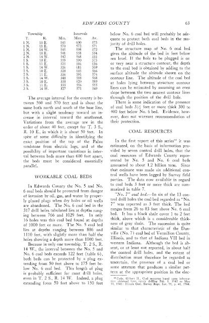
The average interval for <strong>the</strong> county is between<br />
560 <strong>and</strong> 570 feet <strong>and</strong> is about <strong>the</strong><br />
same both north <strong>and</strong> south <strong>of</strong> <strong>the</strong> base line,<br />
but with a slight tendency toward an increase<br />
in interval toward <strong>the</strong> southwest.<br />
Variations from <strong>the</strong> average are in <strong>the</strong><br />
order <strong>of</strong> about 40 feet, except for T. 3 S.,<br />
R. 10 E., in which it is about 50 feet. In<br />
spite <strong>of</strong> some difficulty in identifying <strong>the</strong><br />
exact position <strong>of</strong> <strong>the</strong> top <strong>of</strong> <strong>the</strong> Palzo<br />
s<strong>and</strong>stone from electric logs, <strong>and</strong> <strong>of</strong> <strong>the</strong><br />
possibility <strong>of</strong> important variations in interval<br />
between beds more than 600 feet apart,<br />
<strong>the</strong> beds must be considered essentially<br />
parallel.<br />
WORKABLE COAL BEDS<br />
In Edwards County <strong>the</strong> No. 5 <strong>and</strong> No.<br />
6 <strong>coal</strong> beds should be protected from danger<br />
<strong>of</strong> invasion by oil, gas, <strong>and</strong> water by properly<br />
placed plugs when dry holes or oil wells<br />
are ab<strong>and</strong>oned. The No. 6 <strong>coal</strong> bed in <strong>the</strong><br />
317 drill holes tabulated lies at depths ranging<br />
between 766 <strong>and</strong> 1029 feet. In only<br />
16 holes was this <strong>coal</strong> bed found at depths<br />
<strong>of</strong> 1000 feet or more. The No. 5 <strong>coal</strong> bed<br />
lies at depths ranging between 886 <strong>and</strong><br />
1110 feet, with slightly more than half <strong>the</strong><br />
holes showing a depth more than 1000 feet.<br />
Because in only one township, T. 2 S., R.<br />
14 W., <strong>the</strong> interval between <strong>the</strong> No. 5 <strong>and</strong><br />
No. 6 <strong>coal</strong> beds exceeds 122 feet (table 6),<br />
both beds can be protected by a plug extending<br />
from 50 feet above to 175 feet below<br />
No. 6 <strong>coal</strong> bed. This length <strong>of</strong> plug<br />
is probably sufficient for most drill holes,<br />
even in T. 2 S., R. 14 W. Indeed, a plug<br />
extending from 50 feet above to 150 feet<br />
COUNTY 6 3<br />
below No. 6 <strong>coal</strong> bed will probably be adequate<br />
to protect both <strong>coal</strong> beds in <strong>the</strong> majority<br />
<strong>of</strong> drill holes.<br />
The structure map <strong>of</strong> No. 6 <strong>coal</strong> bed<br />
gives <strong>the</strong> altitude <strong>of</strong> <strong>the</strong> bed in feet below<br />
sea level. If <strong>the</strong> hole to be plugged is on<br />
or very near a structure contour, <strong>the</strong> depth<br />
to <strong>the</strong> <strong>coal</strong> bed is obtained by adding to <strong>the</strong><br />
surface altitude <strong>the</strong> altitude shown on <strong>the</strong><br />
contour line. The altitude <strong>of</strong> <strong>the</strong> <strong>coal</strong> bed<br />
at holes lying between structure contour<br />
lines can be estimated by assuming an even<br />
slope between <strong>the</strong> two nearest contour lines<br />
through <strong>the</strong> position <strong>of</strong> <strong>the</strong> drill hole.<br />
There is some indication <strong>of</strong> <strong>the</strong> presence<br />
<strong>of</strong> <strong>coal</strong> beds 3$4 feet or more thick 300 to<br />
400 feet below No. 6 bed. Evidence, however,<br />
does not warrant recommendation <strong>of</strong><br />
<strong>the</strong>ir protection.<br />
COAL RESOU RCES<br />
In <strong>the</strong> first report <strong>of</strong> this series" it was<br />
estimated, on <strong>the</strong> basis <strong>of</strong> information provided<br />
by seven control drill holes, that <strong>the</strong><br />
<strong>coal</strong> <strong>resources</strong> <strong>of</strong> Edwards County represented<br />
by No. 5 <strong>and</strong> No. 6 <strong>coal</strong> beds<br />
a~nounted to about 1.2 billion tons. Since<br />
that estimate was made six additional control<br />
wells have been logged by Survey field<br />
parties. The data now available in regard<br />
to <strong>coal</strong> beds 3 feet or more thick are summarized<br />
in table 7.<br />
'No. 7" <strong>coal</strong> bed.-In six <strong>of</strong> <strong>the</strong> 13 control<br />
drill holes <strong>the</strong> <strong>coal</strong> bed regarded as "No.<br />
7" was reported as 3 feet thick. The bed<br />
ranges from 26 to 83 feet above No. 6 <strong>coal</strong><br />
bed. It has a black shale cover 1 to 2 feet<br />
thick, above which is a considerable thickness<br />
<strong>of</strong> gray shale. The succession is quite<br />
similar to that characteristic <strong>of</strong> <strong>the</strong> Danville<br />
(No. 7) <strong>coal</strong> bed <strong>of</strong> Vermilion County,<br />
Illinois, <strong>and</strong> to that <strong>of</strong> Indiana VII bed in<br />
western Indiana. Although <strong>the</strong> bed is absent,<br />
or at least not reported, in about half<br />
<strong>the</strong> control drill holes, <strong>and</strong> <strong>the</strong> extent <strong>of</strong><br />
distribution must <strong>the</strong>refore be regarded as<br />
uncertain, <strong>the</strong> presence <strong>of</strong> a <strong>coal</strong> bed or<br />
some stratum that produces a similar pattern<br />
at <strong>the</strong> appropriate position in <strong>the</strong> elec-<br />
IG Cadv Gilbert H., Coal <strong>resources</strong> based upon inforrna-<br />
,inn obtained from rotarv drilling Feb. 1 1942 to May<br />
3 1. 1913 : Illinois Geol. Lrvey Rept. Inv. $3, p. 41, 1944.


