

subsurface geology and coal resources of the pennsylvanian system ...
subsurface geology and coal resources of the pennsylvanian system ...
subsurface geology and coal resources of the pennsylvanian system ...

Create successful ePaper yourself
Turn your PDF publications into a flip-book with our unique Google optimized e-Paper software.
ILLINOIS BASIN COAL RESOURCES<br />
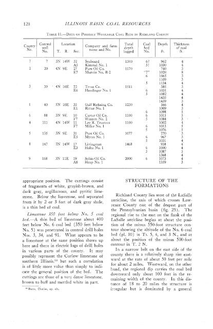
County<br />
No.<br />
1 we].<br />
I<br />
Control<br />
No.<br />
TABLE 11.-DATA OK POSSIBLY JYORRABLE COAL BEDS IN RICHLAND COUNTY<br />
Location<br />
T. R. Sec.<br />
Company <strong>and</strong> farm<br />
name <strong>and</strong> No.<br />
Seaboard<br />
Kimmel No. 1<br />
Pure Oil Co.<br />
Murvin No. R-2<br />
Total<br />
depth<br />
logged<br />
Coal<br />
bed<br />
No.<br />
Depth<br />
ft.<br />
Thickness<br />
<strong>of</strong> <strong>coal</strong><br />
ft.<br />
Te~as Co.<br />
Hasslinger No. 1<br />
Gulf Refining Co.<br />
Ritter No. 1<br />
Carter Oil Co.<br />
Winters No. 2<br />
Lre R. Trustees<br />
Miller hTo. 1<br />
Pure Oil Co.<br />
Myers No. 1<br />
Livingston<br />
Holtz No. 1<br />
Sohio Oil Co.<br />
Heap No. 1<br />
appropriate position. The cuttings consist<br />
<strong>of</strong> fragments <strong>of</strong> white, grayish-brown, <strong>and</strong><br />
dark gray, argillaceous, <strong>and</strong> pyritic limestone.<br />
Below <strong>the</strong> limestone, <strong>and</strong> separated<br />
from it by 2 or 3 feet <strong>of</strong> dark gray shale,<br />
is a thin bed <strong>of</strong> <strong>coal</strong>.<br />
Limestone 350 feet below No. 5 cod<br />
bed.-A thin bed <strong>of</strong> limestone about 400<br />
feet below No. 6 <strong>coal</strong> bed (350 feet below<br />
No. 5) was penetrated in control drill holes<br />
Nos. 3, 34, <strong>and</strong> 91. What appears to be<br />
a limestone at <strong>the</strong> same position shows up<br />
here <strong>and</strong> <strong>the</strong>re in electric logs <strong>of</strong> drill holes<br />
in various parts <strong>of</strong> <strong>the</strong> county. It may<br />
possibly represent <strong>the</strong> Curlew limestone <strong>of</strong><br />
sou<strong>the</strong>rn Illinois,l"ut such a correlation<br />
is <strong>of</strong> little more value than simply to indicate<br />
<strong>the</strong> general position <strong>of</strong> <strong>the</strong> bed. The<br />
cuttings are those <strong>of</strong> a very dense limestone,<br />
brown to buff <strong>and</strong> mottled white in part.<br />
butt^, Charles, op. cit.<br />
STRUCTURE OF THE<br />
FORMATIONS<br />
Richl<strong>and</strong> County lies west <strong>of</strong> <strong>the</strong> LaSalle<br />
anticline, <strong>the</strong> axis <strong>of</strong> which crosses Lawrence<br />
County east <strong>of</strong> <strong>the</strong> deepest part <strong>of</strong><br />
<strong>the</strong> Pennsylvanian basin (fig. 25). The<br />
regional rise to <strong>the</strong> east on <strong>the</strong> flank <strong>of</strong> <strong>the</strong><br />
LaSalle anticline begins at about <strong>the</strong> position<br />
<strong>of</strong> <strong>the</strong> minus 550-foot structure contour<br />
showing <strong>the</strong> altitude <strong>of</strong> <strong>the</strong> No. 6 <strong>coal</strong><br />
bed (pl. 10) in Ts. 5, 4, <strong>and</strong> 3 N., <strong>and</strong> at<br />
about <strong>the</strong> position <strong>of</strong> <strong>the</strong> minus 500-foot<br />
contour in T. 2 N.<br />
In a narrow belt on <strong>the</strong> east side <strong>of</strong> <strong>the</strong><br />
county <strong>the</strong>re is a relatively sharp rise eastward<br />
at <strong>the</strong> rate <strong>of</strong> about 50 feet per mile<br />
for about 2 miles. Westward, on <strong>the</strong> o<strong>the</strong>r<br />
h<strong>and</strong>, <strong>the</strong> regional dip carries <strong>the</strong> <strong>coal</strong> bed<br />
downward only about 100 feet in <strong>the</strong> remaining<br />
width <strong>of</strong> <strong>the</strong> county. In this distance<br />
<strong>of</strong> 18 to 20 miles <strong>the</strong> structure is<br />
irregular but is dominated by a general


