Manual for Integrated District Planning - National Institute of Rural ...
Manual for Integrated District Planning - National Institute of Rural ...
Manual for Integrated District Planning - National Institute of Rural ...

You also want an ePaper? Increase the reach of your titles
YUMPU automatically turns print PDFs into web optimized ePapers that Google loves.
<strong>Manual</strong> <strong>for</strong> <strong>Integrated</strong> <strong>District</strong> <strong>Planning</strong><br />
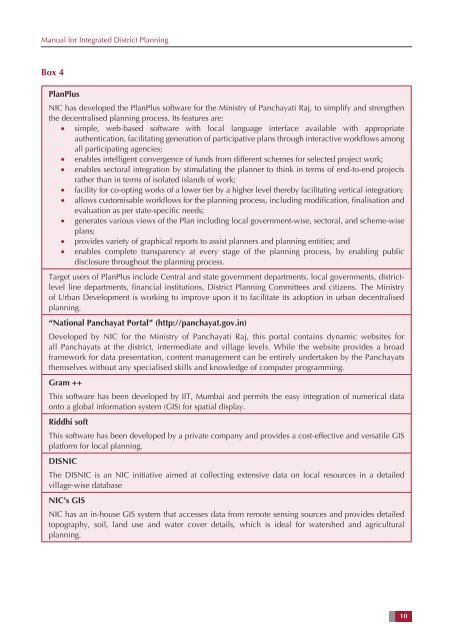
Box 4<br />
PlanPlus<br />
NIC has developed the PlanPlus s<strong>of</strong>tware <strong>for</strong> the Ministry <strong>of</strong> Panchayati Raj, to simplify and strengthen<br />
the decentralised planning process. Its features are:<br />
• simple, web-based s<strong>of</strong>tware with local language interface available with appropriate<br />
authentication, facilitating generation <strong>of</strong> participative plans through interactive workflows among<br />
all participating agencies;<br />
• enables intelligent convergence <strong>of</strong> funds from different schemes <strong>for</strong> selected project work;<br />
• enables sectoral integration by stimulating the planner to think in terms <strong>of</strong> end-to-end projects<br />
rather than in terms <strong>of</strong> isolated islands <strong>of</strong> work;<br />
• facility <strong>for</strong> co-opting works <strong>of</strong> a lower tier by a higher level thereby facilitating vertical integration;<br />
• allows customisable workflows <strong>for</strong> the planning process, including modification, finalisation and<br />
evaluation as per state-specific needs;<br />
• generates various views <strong>of</strong> the Plan including local government-wise, sectoral, and scheme-wise<br />
plans;<br />
• provides variety <strong>of</strong> graphical reports to assist planners and planning entities; and<br />
• enables complete transparency at every stage <strong>of</strong> the planning process, by enabling public<br />
disclosure throughout the planning process.<br />
Target users <strong>of</strong> PlanPlus include Central and state government departments, local governments, districtlevel<br />
line departments, financial institutions, <strong>District</strong> <strong>Planning</strong> Committees and citizens. The Ministry<br />
<strong>of</strong> Urban Development is working to improve upon it to facilitate its adoption in urban decentralised<br />
planning.<br />
“<strong>National</strong> Panchayat Portal” (http://panchayat.gov.in)<br />
Developed by NIC <strong>for</strong> the Ministry <strong>of</strong> Panchayati Raj, this portal contains dynamic websites <strong>for</strong><br />
all Panchayats at the district, intermediate and village levels. While the website provides a broad<br />
framework <strong>for</strong> data presentation, content management can be entirely undertaken by the Panchayats<br />
themselves without any specialised skills and knowledge <strong>of</strong> computer programming.<br />
Gram ++<br />
This s<strong>of</strong>tware has been developed by IIT, Mumbai and permits the easy integration <strong>of</strong> numerical data<br />
onto a global in<strong>for</strong>mation system (GIS) <strong>for</strong> spatial display.<br />
Riddhi s<strong>of</strong>t<br />
This s<strong>of</strong>tware has been developed by a private company and provides a cost-effective and versatile GIS<br />
plat<strong>for</strong>m <strong>for</strong> local planning.<br />
DISNIC<br />
The DISNIC is an NIC initiative aimed at collecting extensive data on local resources in a detailed<br />
village-wise database<br />
NIC’s GIS<br />
NIC has an in-house GIS system that accesses data from remote sensing sources and provides detailed<br />
topography, soil, land use and water cover details, which is ideal <strong>for</strong> watershed and agricultural<br />
planning.<br />
10