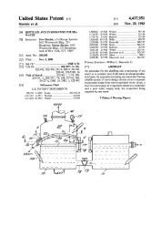
CD-Sextant - Build your own sextant - Pole Shift Survival Information
CD-Sextant - Build your own sextant - Pole Shift Survival Information
CD-Sextant - Build your own sextant - Pole Shift Survival Information

You also want an ePaper? Increase the reach of your titles
YUMPU automatically turns print PDFs into web optimized ePapers that Google loves.
Navigator Light Software<br />
●<br />
data.<br />
Click 'Calculate' to calculate the<br />
astronomical position.<br />
Simple meridian passage (noon sight)<br />
back to the top<br />
When the Sun crosses our meridian, its azimuth is either 0° or 180° (North or South). This means that a Line of Position<br />
(LOP) for the Sun, taken at this time, will have constant latitude. This event is called transit or meridian passage. For the<br />
Sun, it happens around local noon (+/- 20 minutes).<br />
The navigator can take advantage of this event to check the latitude. The longitude can also be calculated, although with<br />
smaller precision.<br />
This is what you must do:<br />
● Start taking observations of the Sun (time and altitude) about 25 minutes before the expected transit time. In<br />
Navigator, select the Sun and use the command Object Data to estimate the transit time for the Sun in <strong>your</strong> assumed<br />
position. Take a couple altitude observations (p.e. 5 minutes apart) until 15 minutes before transit.<br />
●<br />
At transit time, observe the highest altitude the Sun reaches. This is kn<strong>own</strong> as culmination altitude. It´s easy to<br />
measure, since the Sun will appear to hang with constant altitude while passing <strong>your</strong> meridian. After that, it will start<br />
to go d<strong>own</strong>.<br />
●<br />
●<br />
Write the culmination (maximum) altitude.<br />
Keep checking the altitude until the Sun, now going d<strong>own</strong>, is at the same altitude it was in one of the observations<br />
made before transit. The time of transit is the average of two times with equal altitudes (before and after transit).<br />
For example, if you measured 61°32' at 11:45:30 and 61°32' at 12:10:10, the time of transit is (11:45:30+12:10:10)/2<br />
or 11:57:50. The altitude value is the maximum altitude you observed (near transit time).<br />
●<br />
Enter the transit time (the average you calculated) and the culmination altitude in Navigator. Select the tab "Other<br />
calculations" and click the "Simple Sun Meridian Passage" button. Program will give <strong>your</strong> position.<br />
It's important to understand that the Latitude result is related to the maximum altitude the Sun reaches, and the Longitude to<br />
http://www.tecepe.com.br/nav/navpro.htm (8 of 23) [9/2/2004 11:05:07 PM]