Geomatica WebServer Installation Guide.book - UNBC GIS / Remote ...
Geomatica WebServer Installation Guide.book - UNBC GIS / Remote ...
Geomatica WebServer Installation Guide.book - UNBC GIS / Remote ...

Create successful ePaper yourself
Turn your PDF publications into a flip-book with our unique Google optimized e-Paper software.
Chapter 5 - Configuring the Servlet for the Web Mapping Service (WMS)<br />
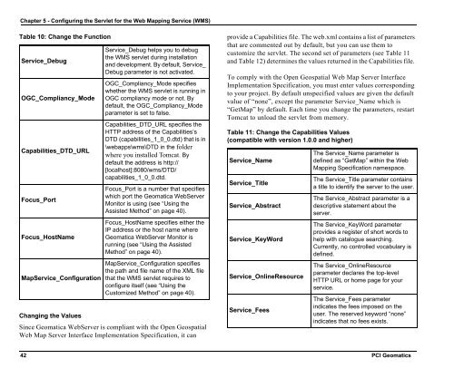
Table 10: Change the Function<br />
Service_Debug<br />
OGC_Compliancy_Mode<br />
Capabilities_DTD_URL<br />
Focus_Port<br />
Focus_HostName<br />
MapService_Configuration<br />
Changing the Values<br />
Service_Debug helps you to debug<br />
the WMS servlet during installation<br />
and development. By default, Service_<br />
Debug parameter is not activated.<br />
OGC_Compliancy_Mode specifies<br />
whether the WMS servlet is running in<br />
OGC compliancy mode or not. By<br />
default, the OGC_Compliancy_Mode<br />
parameter is set to false.<br />
Capabilities_DTD_URL specifies the<br />
HTTP address of the Capabilities’s<br />
DTD (capabilities_1_0_0.dtd) that is in<br />
\webapps\wms\DTD in the folder<br />
where you installed Tomcat. By<br />
default the address is http://<br />
[localhost]:8080/wms/DTD/<br />
capabilities_1_0_0.dtd.<br />
Focus_Port is a number that specifies<br />
which port the <strong>Geomatica</strong> <strong>WebServer</strong><br />
Monitor is using (see “Using the<br />
Assisted Method” on page 40).<br />
Focus_HostName specifies either the<br />
IP address or the host name where<br />
<strong>Geomatica</strong> <strong>WebServer</strong> Monitor is<br />
running (see “Using the Assisted<br />
Method” on page 40).<br />
MapService_Configuration specifies<br />
the path and file name of the XML file<br />
that the WMS servlet requires to<br />
configure itself (see “Using the<br />
Customized Method” on page 40).<br />
Since <strong>Geomatica</strong> <strong>WebServer</strong> is compliant with the Open Geospatial<br />
Web Map Server Interface Implementation Specification, it can<br />
provide a Capabilities file. The web.xml contains a list of parameters<br />
that are commented out by default, but you can use them to<br />
customize the servlet. The second set of parameters (see Table 11<br />
and Table 12) determines the values returned in the Capabilities file.<br />
To comply with the Open Geospatial Web Map Server Interface<br />
Implementation Specification, you must enter values corresponding<br />
to your project. By default unspecified values are given the default<br />
value of “none”, except the parameter Service_Name which is<br />
“GetMap” by default. Each time you change the parameters, restart<br />
Tomcat to unload the servlet from memory.<br />
Table 11: Change the Capabilities Values<br />
(compatible with version 1.0.0 and higher)<br />
Service_Name<br />
Service_Title<br />
Service_Abstract<br />
Service_KeyWord<br />
Service_OnlineResource<br />
Service_Fees<br />
The Service_Name parameter is<br />
defined as “GetMap” within the Web<br />
Mapping Specification namespace.<br />
The Service_Title parameter contains<br />
a title to identify the server to the user.<br />
The Service_Abstract parameter is a<br />
descriptive statement about the<br />
server.<br />
The Service_KeyWord parameter<br />
provides a register of short words to<br />
help with catalogue searching.<br />
Currently, no controlled vocabulary is<br />
defined.<br />
The Service_OnlineResource<br />
parameter declares the top-level<br />
HTTP URL or home page for your<br />
service.<br />
The Service_Fees parameter<br />
indicates the fees imposed on the<br />
user. The reserved keyword “none”<br />
indicates that no fees exists.<br />
42 PCI Geomatics