Geomatica WebServer Installation Guide.book - UNBC GIS / Remote ...
Geomatica WebServer Installation Guide.book - UNBC GIS / Remote ...
Geomatica WebServer Installation Guide.book - UNBC GIS / Remote ...
You also want an ePaper? Increase the reach of your titles
YUMPU automatically turns print PDFs into web optimized ePapers that Google loves.
Chapter 5 - Configuring the Servlet for the Web Mapping Service (WMS)<br />
2. Type the following in the address bar of your browser:<br />
http://[localhost]:8080/wms/Reset.html<br />
Replace [localhost] by the name of the computer or IP address<br />
where Tomcat is installed.<br />
Exploring the Syntax of the Servlet’s<br />
Configuration File<br />
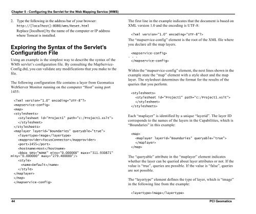
Using an example is the simplest way to describe the syntax of the<br />
WMS servlet’s configuration file. By consulting the MapService-<br />
Config.dtd, you can validate any modifications that you make to the<br />
file.<br />
The following configuration file contains a layer from <strong>Geomatica</strong><br />
<strong>WebServer</strong> Monitor running on the computer “Host” using port<br />
1455:<br />
<br />
<br />
<br />
<br />
<br />
<br />
<br />
<br />
image<br />
FocusConnector<br />
1455<br />
Host<br />
<br />
<br />
Default<br />
<br />
<br />
<br />
<br />
The first line in the example indicates that the document is based on<br />
XML version 1.0 and the encoding is UTF-8:<br />
<br />
The “mapservice-config” element is the root of the XML file where<br />
you declare all the map layers.<br />
<br />
. . .<br />
<br />
Within the “mapservice-config” element, the next lines shown in the<br />
example state the “map” element with a style sheet and the map<br />
layer. The stylesheet determines the format for the results of the<br />
queries that you perform.<br />
<br />
<br />
<br />
<br />
Each “maplayer” is identified by a unique “layerid”. The layer ID<br />
corresponds to the names of the layers in the Capabilities, which is<br />
“Boundaries” in this example:<br />
<br />
<br />
<br />
<br />
The “queryable” attribute in the “maplayer” element indicates<br />
whether the layer can be queried about layer attributes or not. If the<br />
value is “true”, queries are possible. If the value is “false”, queries<br />
are not possible.<br />
The “layertype” element defines the type of layer, which is “image”<br />
in the following line from the example:<br />
image<br />
44 PCI Geomatics


