Geomatica WebServer Installation Guide.book - UNBC GIS / Remote ...
Geomatica WebServer Installation Guide.book - UNBC GIS / Remote ...
Geomatica WebServer Installation Guide.book - UNBC GIS / Remote ...
You also want an ePaper? Increase the reach of your titles
YUMPU automatically turns print PDFs into web optimized ePapers that Google loves.
Chapter 5 - Configuring the Servlet for the Web Mapping Service (WMS)<br />
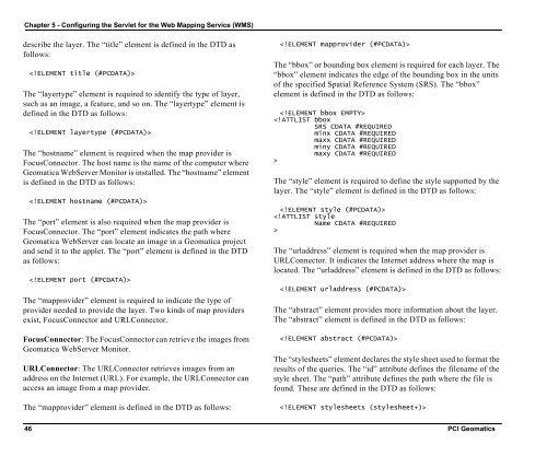
describe the layer. The “title” element is defined in the DTD as<br />
follows:<br />
<br />
The “layertype” element is required to identify the type of layer,<br />
such as an image, a feature, and so on. The “layertype” element is<br />
defined in the DTD as follows:<br />
<br />
The “hostname” element is required when the map provider is<br />
FocusConnector. The host name is the name of the computer where<br />
<strong>Geomatica</strong> <strong>WebServer</strong> Monitor is installed. The “hostname” element<br />
is defined in the DTD as follows:<br />
<br />
The “port” element is also required when the map provider is<br />
FocusConnector. The “port” element indicates the path where<br />
<strong>Geomatica</strong> <strong>WebServer</strong> can locate an image in a <strong>Geomatica</strong> project<br />
and send it to the applet. The “port” element is defined in the DTD<br />
as follows:<br />
<br />
The “mapprovider” element is required to indicate the type of<br />
provider needed to provide the layer. Two kinds of map providers<br />
exist, FocusConnector and URLConnector.<br />
FocusConnector: The FocusConnector can retrieve the images from<br />
<strong>Geomatica</strong> <strong>WebServer</strong> Monitor.<br />
URLConnector: The URLConnector retrieves images from an<br />
address on the Internet (URL). For example, the URLConnector can<br />
access an image from a map provider.<br />
The “mapprovider” element is defined in the DTD as follows:<br />
<br />
The “bbox” or bounding box element is required for each layer. The<br />
“bbox” element indicates the edge of the bounding box in the units<br />
of the specified Spatial Reference System (SRS). The “bbox”<br />
element is defined in the DTD as follows:<br />
<br />
<br />
The “style” element is required to define the style supported by the<br />
layer. The “style” element is defined in the DTD as follows:<br />
<br />
<br />
The “urladdress” element is required when the map provider is<br />
URLConnector. It indicates the Internet address where the map is<br />
located. The “urladdress” element is defined in the DTD as follows:<br />
<br />
The “abstract” element provides more information about the layer.<br />
The “abstract” element is defined in the DTD as follows:<br />
<br />
The “stylesheets” element declares the style sheet used to format the<br />
results of the queries. The “id” attribute defines the filename of the<br />
style sheet. The “path” attribute defines the path where the file is<br />
found. These are defined in the DTD as follows:<br />
<br />
46 PCI Geomatics


