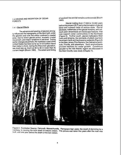
1.4 ORIGINS AND MIGRATION OF CEDARFORESTS<strong>The</strong> advance and wasting <strong>of</strong> glaciers stronglyInfluenced the topography <strong>of</strong> the land both underrhs glaciers and over the entire continent's coastalarea, due to direct glacial action, isostatic crustalmovement, and major variations in sea level. Duringaariior Interglacial periods, the northeast coast <strong>of</strong> theUnited States has been as far as 72 km further inlandthan today's shore; during the Wisconsin glaciation,stscl Ievei was as much as 60 to 80 m lower than itscurrent height (Bloom 1983). <strong>The</strong> extent and timing<strong>of</strong> sea level rise and fall remains controversial (Bloom1 983).Glacial melting from 17,000 to 10,000 yearsbefore the present (B.P.) led tothe formation <strong>of</strong> glaciallakes and outwash beds <strong>of</strong> various sizes. Glaciallakebeds, kettleholes <strong>of</strong> the glacial moraine, and outwashplain streambeds are landscape features thatnow support <strong>cedar</strong> communities in the Northeast(Figure 5). Further south, glacial meltwaters filledrivers and streams, the remnants <strong>of</strong> which now formthe stream bank and backswamp <strong>wetlands</strong> (Figure 6)in the New Jersey Pine Barrens, the Delmarva peninsula,Florida, and elsewhere. Such environmentsprovide habitats for <strong>cedar</strong> growth. Conditionspeculiar to the mid-<strong>Atlantic</strong> region are discussed inthe Dare County case study (Chapter 7).Figure 4 Cumloden Swamp. Falmouth. Massachusetts. Permanent high water, the result <strong>of</strong> damming by a'~(iway, IS causing tho slow death <strong>of</strong> mature <strong>cedar</strong>s. This picture was taken fwe years after the road wasbuilt, and an@ year before the death <strong>of</strong> the last <strong>cedar</strong>s.
Stagnant,,- melting Icel Block d~agrams. very large vert~cal exaggeration l1NET EROSIONTertiary depositsTerminal moraineNET DEPOSITIONfanFigure 5. Origins <strong>of</strong> glacial kettle and outwash <strong>wetlands</strong>.Conditions close to the margin <strong>of</strong> an almoststagnant ice sheet are shown diagrammatically in theupper block diagram. <strong>The</strong> lower diagram shows thesame area after the ice is entirely gone. Cedar forestsdevelop in kettles and along outwash channels(adapted from Strahler 1966).Backswamp FIOO~ River meander\ basin /1.4.2 ~lishment and SurvivalSince the beginning <strong>of</strong> the current interglacialperiod, the long-term overall rise in sealevel, averaging about one mm per year due to glacialmelting and land subsidence, has played an importantrole in the development <strong>of</strong> many <strong>cedar</strong> <strong>wetlands</strong>.A. Redfield, (1965) in the context <strong>of</strong> a rising sea level,proposed a model for the development <strong>of</strong> coastal saltmarshes, which he extended to the development <strong>of</strong>coastal freshwater swamps (A. Redfield, pers.comm.). Redfield noted that near the seacoast, therising sea level more or less keeps pace with peat accumulationlifting the lens <strong>of</strong> freshwater above it.<strong>The</strong> effect <strong>of</strong> the rise in ground-water levels is that existing<strong>wetlands</strong> remain wet, promoting the continuouspresence <strong>of</strong> some <strong>cedar</strong> swamps for as muchas 6,800 years (Belling 1977).Along the coast, seawater inundated freshwater<strong>wetlands</strong>, giving rise to the accumulation <strong>of</strong>layers <strong>of</strong> saltmarsh peat superimposed on freshwaterpeat. Ample macr<strong>of</strong>ossil evidence <strong>of</strong> the killing <strong>of</strong><strong>cedar</strong> forests by saline incursion is found all along theNET DEPOSITIONriver meander beltY~lluvial fan<strong>of</strong> tributaryFigure 6. Origins <strong>of</strong> backswamp <strong>cedar</strong> <strong>wetlands</strong>. (a)When sea level was below the present position, theriver trenched its valley. (b) As sea level rose, glacialmeltwater poured down the river, creating a braidedstream choked with sand and gravel. (c) Deposits <strong>of</strong>today's meandering river, established at a yet highersea-level position, have buried the older braidedstream deposits. Cedar <strong>wetlands</strong> develop in backswampsand along small streambanks (adaptedfrom Long 1974).<strong>Atlantic</strong> seaboard (Figure 7). <strong>Atlantic</strong> <strong>white</strong> <strong>cedar</strong>trunks, sometimes in the same position as in life oras they fell hundreds <strong>of</strong> years earlier, may be seen atlow tides below saltmarsh turf on the coasts <strong>of</strong> NewHampshire, Massachusetts, New Jersey, Virginia,and elsewhere (Bartlett 1909; Heusser 1949, 1963;Belling 1977), and buried deep in <strong>of</strong>f-shore marinesediments (Redfield and Rubin 1962).
- Page 1: Biological Report 85(7.21)July 1989
- Page 5 and 6: PREFACEThis monograph on the ecolog
- Page 7 and 8: CONTENTSea9tl.PREFACE .............
- Page 9 and 10: NumberTABLESEarliest records of Atl
- Page 11 and 12: - CHAPTER 1 -INTRODUCTION1 .I GENER
- Page 13: TEMPORARLYSEASONALLY1I SATURATED1Fi
- Page 17: Table I. Earliest records of Atlant
- Page 20 and 21: CHAPTER 2 -REGIONAL OVERVIEW2.1 INT
- Page 22 and 23: stands are scattered north and west
- Page 24 and 25: state and is gathering data hithert
- Page 26 and 27: corner of the state, and Uttertown
- Page 28 and 29: hardwood stands, or as isolated tre
- Page 30 and 31: cedar have comprised 40%-60% of the
- Page 32 and 33: tablished. Drainage from 224 krn of
- Page 34 and 35: perennial streams (Figure 18) and i
- Page 36 and 37: - CHAPTER 3 -CHAMAECYPARIS THYOIDES
- Page 38 and 39: Ms&gua As early as 1923, Akermandes
- Page 40 and 41: - CHAPTER 4 -STRUCTURE AND FUNCTION
- Page 42 and 43: ottomland-isolatedtill & bedrockupl
- Page 44 and 45: Table 5. Mean August tissue nutrien
- Page 46 and 47: - CHAPTER 5 -BIOLOGICAL COMPONENTS
- Page 48 and 49: Figure 24a. Companions: plants freq
- Page 50 and 51: Figure 24c. Companions: Plants freq
- Page 52 and 53: ?able 7. Comparison of bird species
- Page 54 and 55: Meanley (1979) emphasized the impor
- Page 56 and 57: - CHAPTER 6 -MANAGEMENT AND HARVEST
- Page 58 and 59: FireBurnedtreesPeatGlacialrubble-Tr
- Page 60 and 61: Mixedhardwood& shrubsPeatGlacialrub
- Page 62 and 63: acidity is reduced, and ammonia, ph
- Page 64 and 65:
and condition of the soil surface a
- Page 66 and 67:
sprouts and shade-tolerant shrubs g
- Page 68 and 69:
Figure 32. Atlantic white cedar reg
- Page 70 and 71:
sedhflings, conversely, canopy open
- Page 72 and 73:
FORESTMANAGEMENTSCHEMAT I CLEGEND-
- Page 74 and 75:
-.- Rsfupe BoundaryState BoundaryRo
- Page 76 and 77:
NATIONAL WILDLIFE RERX;EVirginia an
- Page 78 and 79:
Figure 38. Alligator River (North C
- Page 80 and 81:
Mainland Dare County is located on
- Page 82 and 83:
The cedar swamp forests along the A
- Page 84 and 85:
IPure Atlanticwhite cedar standsy-J
- Page 86 and 87:
Generally, the mixed swamp forest s
- Page 88 and 89:
species of mammals are recorded by
- Page 90 and 91:
Braun-Blanquet, J. [I 9321 1983. Pl
- Page 92 and 93:
Ferguson, R.H., and C.E. Meyer. 197
- Page 94 and 95:
Littte, S. 1953. Prescribed burning
- Page 96 and 97:
Porter, D.M. 1979. Rare and endange
- Page 98 and 99:
Gov. Print. Off., Washington, DC. (
- Page 101 and 102:
APPENDIX A. Flora Associated with C
- Page 103 and 104:
APPENDIX A. Flora: Trees (6ontin~ed
- Page 106 and 107:
APPENDIX A. Flora: Shrubs (Continue
- Page 108 and 109:
APPENDIX A. Fiora: Herbs (Continud)
- Page 110 and 111:
APPENDIX A. Flora: Herbs (Continued
- Page 112 and 113:
APPENDIX A. flora: Herbs (Continued
- Page 114 and 115:
APPENDIX A. Flora: Herbs (Continued
- Page 116 and 117:
APPENDIX A. Flora: Herbs (Continued
- Page 118 and 119:
APPENDIX B. FAUNA OF ATLANTIC WHITE
- Page 120 and 121:
APPENDIX C. Hydric Soilsis a soil t
- Page 122 and 123:
Frost, CecilFuller, ManleyFunk, Dav
- Page 124 and 125:
Ward, Daniel B.Whigham, DennisWidof