hardwood stands, or as isolated trees or clusters in non-tidal fiver courses, with a few on pond marginsa shrubdominated landscape (tittle 1979; Forman and in isolated swamps. Cedar presence is closely1979). correlated with Delaware soil types (Seyfried 1985).e <strong>of</strong> c-.It must be emphasizedthat the general trend has been toward conversionto other wetland types. ln addition todisturbances noted earlier, the decline <strong>of</strong> thePinelands <strong>cedar</strong> <strong>wetlands</strong> has been hastened byrising sea level, flooding for cranberry production,creation <strong>of</strong> industry-related reservoirs and recreationallakes, and drainage for agricultureand residentialdevelopment (Roman et al. 1987).<strong>The</strong> harvest and management <strong>of</strong> <strong>Atlantic</strong><strong>white</strong> <strong>cedar</strong> in the Pinelands are discussed in detailin Chapter 6.2.3.2 Jhe Delmarva Peninsula<strong>Atlantic</strong> <strong>white</strong> <strong>cedar</strong> exists today on the DelmarvaPeninsula in remnant stands that representonly a fraction <strong>of</strong> the species' former geographicrange (Figure 13). For literature review and furtherdetail, see Dill et al. (1987) and Dill et af. (unpwbl.),from which the following discussion was extracted.Just 322 km long and only 11 3 km at itswidest, the Delmarva peninsula contains all threeDelaware counties, nine Eastern Shore Marylandcounties, and two Eastern Shore Virginia counties. Itis bounded on the north by Pennsylvania; on the eastby the Delaware River, Delaware Bay, and the <strong>Atlantic</strong>Ocean; and on the west by the Susquehanna Riverand Chesapeake Bay. <strong>The</strong>re are two distinct geographicprovinces: (1) the Piedmont Plateau, withrocky, wooded hillsides and rich alluvial stream valleysand (2) the <strong>Atlantic</strong> Coastal Plain, with soils <strong>of</strong>clays, silts, sands, and gravels.<strong>The</strong> average annual temperature is 13" C;average annual precipitation is 11 4.3 cm. For most<strong>of</strong> the year, winds are west to northwest, with a moresoutherly flow in summer.<strong>The</strong> Fall Zone cuts across the northern portion<strong>of</strong> the peninsula in a narrow northeast to southwestband. Here Piedmont streams tumble as muchas 42.7 m to the lnner Coastal Plain below. All <strong>Atlantic</strong><strong>white</strong> <strong>cedar</strong> sites in Delmarva are located belowthe Fall Zone, with a few stands on the lnner CoastalPlain, and none on the Piedmont Plateau.A catalog <strong>of</strong> 58 present and historic sites indicatesthat <strong>white</strong> <strong>cedar</strong> now grows in Kent and SussexCounties, Delaware; Kent, Queen Ann's, Talbot,Dorchester, Wicomico, and Worcester Counties,Maryland; and Accomac County, Virginia. Cedar<strong>wetlands</strong> are found in six watersheds draining intoDelaware Bay: three drain directly in the <strong>Atlantic</strong>Ocean, and five drain into the Chesapeake Bay. Allsites are associated with acid water (ca. pH 5) on theCoastal Plain, where <strong>cedar</strong> is found primarily alongfall zonepopulationFigure 13. <strong>The</strong> probable historical range <strong>of</strong> <strong>Atlantic</strong><strong>white</strong> <strong>cedar</strong> in the Delmarva peninsula,reconstructed from herbarium records and personalcommunications (from Dill el al. 1987).
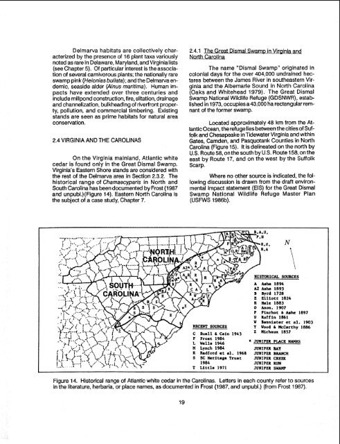
Delma~a habitats are collectively characterizedby the presence <strong>of</strong> 16 plant taxa variouslynoted as rare in Delaware, Maryland, and Virginialists(see Chapter 5). Of particular interest is the association<strong>of</strong> several carnivorous plants; the nationally rareswamp pink (Helonias bullata); and the Delmarva endemic,seaside alder (Ainus maritima). Human impactshave extended over three centuries andinclude millpond construction, fire, siltation, drainageand channelization, bulkheading <strong>of</strong> riverfront property,pollution, and commercial timbering. Existingstands are seen as prime habitats for natural areaconservation.2.4 VIRGINIA AND THE CAROLINASOn the Virginia mainland, <strong>Atlantic</strong> <strong>white</strong><strong>cedar</strong> is found only in the Great Dismal Swamp.Virginia's Eastern Shore stands are considered withthe rest <strong>of</strong> the Delmarva area in Section 2.3.2. <strong>The</strong>historical range <strong>of</strong> Chamaecyparis in North andSouth Carolina has been documented by Frost (1 987and unpubl.)(Figure 14). Eastern North Carolina isthe subject <strong>of</strong> a case study, Chapter 7.2.4.1 <strong>The</strong> Great Dismal Swamp in Vir~ini andNorth Carolina<strong>The</strong> name "Dismal Swamp" originated incolonial days for the over 404,000 undrained hectaresbetween the James River in southeastern Virginiaand the Albemarle Sound in North Carolina(Oaks and Whitehead 1979). <strong>The</strong> Great DismalSwamp <strong>National</strong> Wildlife Refuge (GDSNWR), establishedin 1973, occupies a 43,000 ha rectangular remnant<strong>of</strong> the former swamp.Located approximately 48 km from the <strong>Atlantic</strong>Ocean, the refuge lies between the cities<strong>of</strong> Suffolkand Chesapeake inTidewater Virginia and withinGates, Camden, and Pasquotank Counties in NorthCarolina (Figure 15). It is delineated on the north byU.S. Route 58, on the south by U.S. Route 158, on theeast by Route 17, and on the west by the SuffolkScarp.Where no other source is indicated, the followingdiscussion is drawn from the draft environmentalimpact statement (EIS) for the Great DismalSwamp <strong>National</strong> Wildlife Refuge Master Plan(USFWS 1986b).A hha 1894A2 Ashe 1893II Byrd 1728E Elliott 1624H Hale 18830 Anon. 1907P Piachot b hhe 1897U Ruffin 1861W Bannister et al. 1903Y Wood C McCarthy 18861943 2 Hichaux 1857Figure 14. Historical range <strong>of</strong> <strong>Atlantic</strong> <strong>white</strong> <strong>cedar</strong> in the Carolinas. Letters in each county refer to sourcesin the literature, herbaria, or place names, as documented in Frost (1987, and unpubl.) (from Frost 1987).
- Page 1: Biological Report 85(7.21)July 1989
- Page 5 and 6: PREFACEThis monograph on the ecolog
- Page 7 and 8: CONTENTSea9tl.PREFACE .............
- Page 9 and 10: NumberTABLESEarliest records of Atl
- Page 11 and 12: - CHAPTER 1 -INTRODUCTION1 .I GENER
- Page 13 and 14: TEMPORARLYSEASONALLY1I SATURATED1Fi
- Page 15 and 16: Stagnant,,- melting Icel Block d~ag
- Page 17: Table I. Earliest records of Atlant
- Page 20 and 21: CHAPTER 2 -REGIONAL OVERVIEW2.1 INT
- Page 22 and 23: stands are scattered north and west
- Page 24 and 25: state and is gathering data hithert
- Page 26 and 27: corner of the state, and Uttertown
- Page 30 and 31: cedar have comprised 40%-60% of the
- Page 32 and 33: tablished. Drainage from 224 krn of
- Page 34 and 35: perennial streams (Figure 18) and i
- Page 36 and 37: - CHAPTER 3 -CHAMAECYPARIS THYOIDES
- Page 38 and 39: Ms&gua As early as 1923, Akermandes
- Page 40 and 41: - CHAPTER 4 -STRUCTURE AND FUNCTION
- Page 42 and 43: ottomland-isolatedtill & bedrockupl
- Page 44 and 45: Table 5. Mean August tissue nutrien
- Page 46 and 47: - CHAPTER 5 -BIOLOGICAL COMPONENTS
- Page 48 and 49: Figure 24a. Companions: plants freq
- Page 50 and 51: Figure 24c. Companions: Plants freq
- Page 52 and 53: ?able 7. Comparison of bird species
- Page 54 and 55: Meanley (1979) emphasized the impor
- Page 56 and 57: - CHAPTER 6 -MANAGEMENT AND HARVEST
- Page 58 and 59: FireBurnedtreesPeatGlacialrubble-Tr
- Page 60 and 61: Mixedhardwood& shrubsPeatGlacialrub
- Page 62 and 63: acidity is reduced, and ammonia, ph
- Page 64 and 65: and condition of the soil surface a
- Page 66 and 67: sprouts and shade-tolerant shrubs g
- Page 68 and 69: Figure 32. Atlantic white cedar reg
- Page 70 and 71: sedhflings, conversely, canopy open
- Page 72 and 73: FORESTMANAGEMENTSCHEMAT I CLEGEND-
- Page 74 and 75: -.- Rsfupe BoundaryState BoundaryRo
- Page 76 and 77: NATIONAL WILDLIFE RERX;EVirginia an
- Page 78 and 79:
Figure 38. Alligator River (North C
- Page 80 and 81:
Mainland Dare County is located on
- Page 82 and 83:
The cedar swamp forests along the A
- Page 84 and 85:
IPure Atlanticwhite cedar standsy-J
- Page 86 and 87:
Generally, the mixed swamp forest s
- Page 88 and 89:
species of mammals are recorded by
- Page 90 and 91:
Braun-Blanquet, J. [I 9321 1983. Pl
- Page 92 and 93:
Ferguson, R.H., and C.E. Meyer. 197
- Page 94 and 95:
Littte, S. 1953. Prescribed burning
- Page 96 and 97:
Porter, D.M. 1979. Rare and endange
- Page 98 and 99:
Gov. Print. Off., Washington, DC. (
- Page 101 and 102:
APPENDIX A. Flora Associated with C
- Page 103 and 104:
APPENDIX A. Flora: Trees (6ontin~ed
- Page 106 and 107:
APPENDIX A. Flora: Shrubs (Continue
- Page 108 and 109:
APPENDIX A. Fiora: Herbs (Continud)
- Page 110 and 111:
APPENDIX A. Flora: Herbs (Continued
- Page 112 and 113:
APPENDIX A. flora: Herbs (Continued
- Page 114 and 115:
APPENDIX A. Flora: Herbs (Continued
- Page 116 and 117:
APPENDIX A. Flora: Herbs (Continued
- Page 118 and 119:
APPENDIX B. FAUNA OF ATLANTIC WHITE
- Page 120 and 121:
APPENDIX C. Hydric Soilsis a soil t
- Page 122 and 123:
Frost, CecilFuller, ManleyFunk, Dav
- Page 124 and 125:
Ward, Daniel B.Whigham, DennisWidof