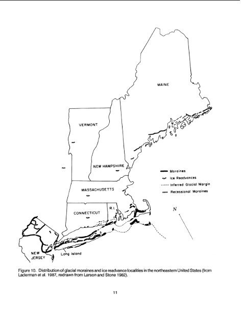
CHAPTER 2 -REGIONAL OVERVIEW2.1 INTRODUCTION<strong>The</strong> aspect <strong>of</strong> an <strong>Atlantic</strong> <strong>white</strong> <strong>cedar</strong> wetlandis so distinctive that the casual observer maythink that all <strong>cedar</strong> swamps are similar in physicalstructure and community composition. This is farfrom the truth when the <strong>cedar</strong> is examined over its entirerange from north to south, from sea level tomountain hollow, from acidic glacial kettle to boggyflatwood or seepage sandhill.Cedar <strong>wetlands</strong> will be most clearly understoodby examining what we know <strong>of</strong> each example.<strong>The</strong>refore, some typical or unusual sites aredescribed below, including those at the farthest extents<strong>of</strong> the <strong>cedar</strong>'s range, the highest elevation<strong>cedar</strong> swamp (altitude: 457 m), a domed bog,swamps with a dense great laurel (Rhododendronmaximum) understory, floating bog mats withdwarfed trees, a wetland in a deep fracture inbedrock, narrow stream-border Pinelands swamps,millponds, a Carolina bay, a sandhill seepage, and asandy stream terrace.2.2 GLACIATED NORTHEAST<strong>Atlantic</strong> <strong>white</strong> <strong>cedar</strong> <strong>wetlands</strong> dot a 130 kmwideband along the coastal region <strong>of</strong> the NortheasternUnited States from the southern extent <strong>of</strong>glaciation (Figure 10) along New York's Long Islandand New Jersey's Hackensack Meadows, north tomid-Maine at 44" north latitude (Figure 11).Charnaecyparis thyoides grows from sea level to457m elevation, but the great majority <strong>of</strong> stands arefound between sea level and 50 m. It is probable thatthe distribution <strong>of</strong> the species was always restrictedto sites too wet for most other northeastern trees.<strong>The</strong>re is standing water in many northern <strong>cedar</strong>swamps for half the growing season or longer(Laderman et al. 1987; Golet and Lowry 1987); thesoil is primarily organic; and ground water is highlyacidic (pH 3.1 - 5.5 [Laderman 1980; Golet and Lowry1 9871).<strong>The</strong> growing season <strong>of</strong> <strong>Atlantic</strong> <strong>white</strong> <strong>cedar</strong>in the glaciated northeast ranges from 139 days inMaine to 21 1 days in northern New Jersey. Summersare relatively cool and wet. Average maximumdaily temperatures in July range between 13 and 16"C. <strong>The</strong> extreme high temperatures, 39 to 41 "C, donot differ from those in the southernmost parts <strong>of</strong> the<strong>cedar</strong>s' range, although the total degree- days andaverage temperatures differ markedly. <strong>The</strong> lowesttemperatures in the glaciated <strong>cedar</strong> wetland arearange from -40 "C in Maine to -22 "C in New Jersey.Average annual precipitation is between 101 and 1 19cm (data from Ruffner and Bair 1981).Generally, Chamaecyparis decreases in abundancewith increasing distance from the coast. Lowtides and storms reveal <strong>cedar</strong> stumps buried undersaltmarsh peat near the coast from Kittery Point,Maine to New Jersey, evidence <strong>of</strong> the slow rise <strong>of</strong> sealevel in this region (Redfield and Rubin 1962). <strong>Atlantic</strong><strong>white</strong> <strong>cedar</strong> was far more plentiful in each <strong>of</strong> thesestates a few hundred years ago, but there is noevidence that its range ever extended significantly tothe west or north <strong>of</strong> its current extent.In New England, <strong>Atlantic</strong> <strong>white</strong> <strong>cedar</strong> is mostabundant in southeastern Massachusetts, Rhode Island,and eastern Connecticut (Golet and Lowry1987; Sorrie and Woolsey 1987; Laderman, unpubl.).Its distribution (Figure 11) appears to be closely relatedto glacial features such as moraine hollows, glacialkettles, or old lake beds.<strong>The</strong>re are 11 known Charnaecyparis standsin Maine (Eastman, unpubl.; B. Vickery, pers. comm.)and about twice that number in New Hampshire (H.Baldwin, pers. comm.; F. Brackley, pers. comm.; f?Auger, pers. comm.). In Massachusetts, <strong>cedar</strong>swamps are found in all but three <strong>of</strong> the 64 towns inBristol, Plymouth, and Barnstable (the State's threemajor southeast counties), and approximately 30
MAINEw NEW HAMPSHIRE-MASSACHUSETTSMorainesw Ice Readvances----- Inferred Glacial Margin~O*O Recessional MorainesCONNECTICUTFigure 10. Distribution <strong>of</strong> glacial moraines and ice readvance localities in the northeastern United States (fromLaderman et al. 1987, redrawn from Larson and Stone 1982).
- Page 1: Biological Report 85(7.21)July 1989
- Page 5 and 6: PREFACEThis monograph on the ecolog
- Page 7 and 8: CONTENTSea9tl.PREFACE .............
- Page 9 and 10: NumberTABLESEarliest records of Atl
- Page 11 and 12: - CHAPTER 1 -INTRODUCTION1 .I GENER
- Page 13 and 14: TEMPORARLYSEASONALLY1I SATURATED1Fi
- Page 15 and 16: Stagnant,,- melting Icel Block d~ag
- Page 17: Table I. Earliest records of Atlant
- Page 22 and 23: stands are scattered north and west
- Page 24 and 25: state and is gathering data hithert
- Page 26 and 27: corner of the state, and Uttertown
- Page 28 and 29: hardwood stands, or as isolated tre
- Page 30 and 31: cedar have comprised 40%-60% of the
- Page 32 and 33: tablished. Drainage from 224 krn of
- Page 34 and 35: perennial streams (Figure 18) and i
- Page 36 and 37: - CHAPTER 3 -CHAMAECYPARIS THYOIDES
- Page 38 and 39: Ms&gua As early as 1923, Akermandes
- Page 40 and 41: - CHAPTER 4 -STRUCTURE AND FUNCTION
- Page 42 and 43: ottomland-isolatedtill & bedrockupl
- Page 44 and 45: Table 5. Mean August tissue nutrien
- Page 46 and 47: - CHAPTER 5 -BIOLOGICAL COMPONENTS
- Page 48 and 49: Figure 24a. Companions: plants freq
- Page 50 and 51: Figure 24c. Companions: Plants freq
- Page 52 and 53: ?able 7. Comparison of bird species
- Page 54 and 55: Meanley (1979) emphasized the impor
- Page 56 and 57: - CHAPTER 6 -MANAGEMENT AND HARVEST
- Page 58 and 59: FireBurnedtreesPeatGlacialrubble-Tr
- Page 60 and 61: Mixedhardwood& shrubsPeatGlacialrub
- Page 62 and 63: acidity is reduced, and ammonia, ph
- Page 64 and 65: and condition of the soil surface a
- Page 66 and 67: sprouts and shade-tolerant shrubs g
- Page 68 and 69: Figure 32. Atlantic white cedar reg
- Page 70 and 71:
sedhflings, conversely, canopy open
- Page 72 and 73:
FORESTMANAGEMENTSCHEMAT I CLEGEND-
- Page 74 and 75:
-.- Rsfupe BoundaryState BoundaryRo
- Page 76 and 77:
NATIONAL WILDLIFE RERX;EVirginia an
- Page 78 and 79:
Figure 38. Alligator River (North C
- Page 80 and 81:
Mainland Dare County is located on
- Page 82 and 83:
The cedar swamp forests along the A
- Page 84 and 85:
IPure Atlanticwhite cedar standsy-J
- Page 86 and 87:
Generally, the mixed swamp forest s
- Page 88 and 89:
species of mammals are recorded by
- Page 90 and 91:
Braun-Blanquet, J. [I 9321 1983. Pl
- Page 92 and 93:
Ferguson, R.H., and C.E. Meyer. 197
- Page 94 and 95:
Littte, S. 1953. Prescribed burning
- Page 96 and 97:
Porter, D.M. 1979. Rare and endange
- Page 98 and 99:
Gov. Print. Off., Washington, DC. (
- Page 101 and 102:
APPENDIX A. Flora Associated with C
- Page 103 and 104:
APPENDIX A. Flora: Trees (6ontin~ed
- Page 106 and 107:
APPENDIX A. Flora: Shrubs (Continue
- Page 108 and 109:
APPENDIX A. Fiora: Herbs (Continud)
- Page 110 and 111:
APPENDIX A. Flora: Herbs (Continued
- Page 112 and 113:
APPENDIX A. flora: Herbs (Continued
- Page 114 and 115:
APPENDIX A. Flora: Herbs (Continued
- Page 116 and 117:
APPENDIX A. Flora: Herbs (Continued
- Page 118 and 119:
APPENDIX B. FAUNA OF ATLANTIC WHITE
- Page 120 and 121:
APPENDIX C. Hydric Soilsis a soil t
- Page 122 and 123:
Frost, CecilFuller, ManleyFunk, Dav
- Page 124 and 125:
Ward, Daniel B.Whigham, DennisWidof