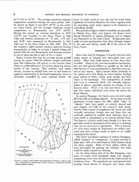
GEOGRAPHYbisects the Republic <strong>of</strong> <strong>Paraguay</strong> in its lower reaches,<strong>and</strong> marks striking differences in topography, vegetation,<strong>and</strong> cultural development between the two parts<strong>of</strong> the country. It has a total fall <strong>of</strong> only 250 meters inits 2,500 kilometer course, <strong>and</strong> a speed through its<strong>Paraguay</strong>an portion <strong>of</strong> 5 to 7 kilometers per hour. Itis several hundred meters wide in most places <strong>and</strong> isgenerally navigable as far as Corumbd, Brazil, by shipswith 3-meter draft <strong>and</strong> even farther by smaller craft.Its course is characterized by innumerable me<strong>and</strong>ers<strong>and</strong> by frequent channel shifts. From the Rio Apasouthward almost to Conception the east bank ismarked by discontinuous cliffs <strong>of</strong> limestone <strong>and</strong> marble,nearly vertical, <strong>and</strong> several tens <strong>of</strong> meters high inplaces. Elsewhere the s<strong>and</strong>y to muddy banks slopegently into the river or form steep cutbanks, carvedfrom flood-plain alluvium <strong>and</strong> only a few meters highat most.The Rio <strong>Paraguay</strong>, with its tributaries, drains all butthe southeastern portion <strong>of</strong> the country. The RioPilcomayo, heading 2,000 kilometers westward in theAndes in Bolivia, <strong>and</strong> forming much <strong>of</strong> the internationalboundary with Argentina, is the largest tributary 011the western or Gran Chaco side <strong>of</strong> the river. It isnavigable in places by small boats. Except for itslength <strong>and</strong> relative continuity, it is similar to any <strong>of</strong>the other streams that drain the Gran Chaco. Normally,they are all sluggish, intermittent, <strong>and</strong> discontinuousstreams that wind their way slowly across thenearly level plains between banks that are seldom morethan a couple <strong>of</strong> meters high. During rainy seasonsthey overflow their banks <strong>and</strong> spread over most <strong>of</strong> thel<strong>and</strong>. Working together, first in one part <strong>of</strong> the GranChaco <strong>and</strong> then in another, they are still building upthe plains. Their loads <strong>of</strong> mud, silt, <strong>and</strong> fine s<strong>and</strong>debris, earned down from the Andes, are redistributedover the plains during periods <strong>of</strong> overflow or by changes<strong>of</strong> course that take place on most streams, if not fromyear to year, at least from decade to decade.Most <strong>of</strong> the eastern part <strong>of</strong> <strong>Paraguay</strong> drains into theRio <strong>Paraguay</strong> through seven main tributaries <strong>and</strong>several smaller ones. Five are 180 to 275 kilometerslong <strong>and</strong> are navigable in part by small boats <strong>and</strong> barges,but all the tributaries are slow <strong>and</strong> shallow in mostplaces <strong>and</strong> subject to frequent shifts in channel.The Rio Alto Parana, about 3,000 kilometers long,heads deep in southeastern Brazil; in its lower reachesit forms the southeastern boundary <strong>of</strong> <strong>Paraguay</strong> for adistance <strong>of</strong> 850 kilometers. On its way toward <strong>Paraguay</strong>it me<strong>and</strong>ers slowly across high basalt plains, butwhere it first touches <strong>Paraguay</strong> it plunges abruptlyover a series <strong>of</strong> jagged basalt escarpments to form theawe-inspiring cataracts <strong>of</strong> Salto del Guaira. Fromthese falls to Encarnaci6n it is incised in basalt <strong>and</strong>follows a relatively straight, narrow <strong>and</strong> swift courseas compared with its upstream or downstream portions.From Encarnaci6n to its junction with the <strong>Paraguay</strong>the stream is broad <strong>and</strong> shallow, characterized byshifting, braided channels. It is navigable by moderatesizedcraft as far upstream as Guaira. The southeasternpart <strong>of</strong> the country drains to the Alto Par<strong>and</strong>by means <strong>of</strong> 11 major tributaries, only 2 <strong>of</strong> which aremore than 150 kilometers long. These, too, are slowme<strong>and</strong>ering streams <strong>and</strong> resemble the tributaries <strong>of</strong>the Rio <strong>Paraguay</strong> in all but two important respects.First, though their me<strong>and</strong>ers superficially resemble theaimless w<strong>and</strong>erings <strong>of</strong> the rivers farther west, on closerstudy they are seen to be related to fracture patternsin the basalt flows that underlie most <strong>of</strong> the area.Second, most <strong>of</strong> the tributaries make their final descentinto the Alto Parana gorge by a series <strong>of</strong> low steplikefalls or rapids where they cross the edges <strong>of</strong> the basaltflows. Recognition <strong>of</strong> these two features is <strong>of</strong> greathelp to the reconnaissance geologist. Moreover, thefalls seem to represent the only potential source <strong>of</strong>hydroelectric energy that is not subject to internationalcomplications.There are two fairly large permanent but shallowlakes in the country Lago Ypoa <strong>and</strong> Lago Ypacarai<strong>and</strong> countless intermittent ponds, lagoons, <strong>and</strong> swamps,some <strong>of</strong> them enormous.CLIMATEThe climate, comparable in some respects to that <strong>of</strong>southern Florida or south-central Texas, ranges fromsubtropical to tropical. <strong>Paraguay</strong> is an interior country<strong>of</strong> hot summers <strong>and</strong> mild winters, with the dominantcharacteristic <strong>of</strong> the weather extreme unpredictabilityfrom month to month <strong>and</strong> from year to year.The winter months, especially July through Septemberare generally somewhat drier <strong>and</strong> considerably colderthan the summer months, December through February,with rainfall ranging between one-fifth <strong>and</strong> two-thirdsthe average <strong>of</strong> all months.The summer months <strong>and</strong> shorter periods throughoutthe year are hot <strong>and</strong> humid, though moderated fromtime to time by heavy rains that may last only a fewminutes or may continue almost steadily for severaldays. Virtually all living habits, from housing arrangementsto business hours, are adjusted to the predominantlywarm parts <strong>of</strong> the year. This is particularlynoticeable during the comparatively few cooler days <strong>of</strong>winter, when tile floors, high ceilings <strong>and</strong> the generallack <strong>of</strong> heating arrangements tend to make temperatures<strong>of</strong> 5° to 10°C (41° to 50°F) somewhatuncomfortable.Figure 3 shows the geographic distribution <strong>of</strong> meanaverage temperatures by isotherms ranging from 22° to
8 GEOLOGY AND MINERAL RESOURCES OF PARAGUAY24° C (72° to 75° F). The average maximum summertemperature measured during the same period, 1940-50, shown on figure 3 was 36°C (97°F) in the northernGran Chaco <strong>and</strong> the average minimum wintertemperature at Encarnacidn was 10°C (50°F).During this period, an extreme maximum <strong>of</strong> 43°C(110°F) was recorded in the Gran Chaco in July1942, <strong>and</strong> extreme minimums <strong>of</strong> 4° <strong>and</strong> 5°C (21°<strong>and</strong> 23°F) were measured at Encarnacion in July1945 <strong>and</strong> in the Gran Chaco in July 1942. Five <strong>of</strong>the country's eight weather stations reported freezingtemperatures or below in at least 1 month during theperiod 1940-50, <strong>and</strong> Encarnacidn had freezing weatherin one or more months in each <strong>of</strong> the 11 years.Figure 3 shows also that the average annual rainfallduring the period 1940-50 inclusive ranged uniformlyfrom 600 millimeters (23 inches) in the western GranChaco to 1,800 millimeters (71 inches) along the easternborder <strong>of</strong> the country. This uniform, <strong>and</strong> ratherabrupt, increase in rainfall from west to east bears noapparent relationship to the local topography, hence isobviously controlled by more regional factors. Of23Average annual temperature,in degrees centigradeFIGURE 3. Average annual rainfall <strong>and</strong> temperatures in <strong>Paraguay</strong>, 1940-50, inclusive.Compiled from various sources, 1953, by Dorothy A. Oassel for the Institute<strong>of</strong> Inter-American Affairs.these, the high Andes on one side <strong>and</strong> the much lowerhighl<strong>and</strong>s <strong>of</strong> southern Brazil on the other, together withthe prevailing north winds, appear to be dominant incontrolling rainfall.The periods <strong>of</strong> highest relative humidity are generallyin March, June, July, <strong>and</strong> August; the lowest occurduring December in eastern <strong>Paraguay</strong> <strong>and</strong> in August<strong>and</strong> September in the Gran Chaco. Evaporation generallyexceeds precipitation from June through Augustin the east <strong>and</strong> during nearly all <strong>of</strong> the year in theGran Chaco.VEGETATIONMore than half <strong>of</strong> <strong>Paraguay</strong> is heavily forested withvirgin st<strong>and</strong>s <strong>of</strong> tropical <strong>and</strong> subtropical trees <strong>and</strong>shrubs. More than 3,000 species <strong>of</strong> these have beenrecorded. Many <strong>of</strong> the trees are deciduous hardwoods,but new leaf growth follows so quickly on the fall <strong>of</strong>older leaves, or even accompanies it, that bare trees arerare at any season. Many species bloom pr<strong>of</strong>usely inthe spring <strong>and</strong> a few bloom at other seasons, lendinggreat masses <strong>of</strong> white, yellow, pink, purple, <strong>and</strong> bluecolors to the l<strong>and</strong>scape. The undergrowth <strong>of</strong> shrubs<strong>and</strong> vines is commonly thick, <strong>and</strong> virtually impenetrablein places, especially around the fringes <strong>of</strong> theforested areas. There is no true rain forest, but here<strong>and</strong> there many individual trees tower far above theforest blanket.In eastern <strong>Paraguay</strong>, the forests once covered nearlyall <strong>of</strong> the hills <strong>and</strong> rolling upl<strong>and</strong>s. In the more heavilypopulated central region, the hills, called "islas" or"isl<strong>and</strong>s," have been partly or entirely cleared <strong>and</strong>now support the bulk <strong>of</strong> the country's farm l<strong>and</strong>s.Farther from centers <strong>of</strong> population the forests are stillvirtually untouched, though here <strong>and</strong> there they arestrikingly marked by angular farm clearings, most <strong>of</strong>them small in comparison to the forests around them.The forestry industry itself, large though it is, does notgenerally result in denudation <strong>of</strong> the l<strong>and</strong> or in clearingsthat can be converted to agriculture. This is becausethe trees most sought by lumbermen are widely scattered<strong>and</strong> their cutting results in little or no visiblethinning <strong>of</strong> the forest.The lower <strong>and</strong> flatter portions <strong>of</strong> eastern <strong>Paraguay</strong>,called "campos" or "campl<strong>and</strong>s," are grass covered inlarge part, with trees <strong>and</strong> brush in thick borders alongthe water courses. Parts <strong>of</strong> these plains, which areused principally for grazing, are swampy, but somecould be easily drained by ditching.On the Gran Chaco side <strong>of</strong> the Rio <strong>Paraguay</strong>, vastareas <strong>of</strong> nearly level grassl<strong>and</strong>s drain into sluggishme<strong>and</strong>ering rivers that are bordered by thick st<strong>and</strong>s <strong>of</strong>deciduous trees. The grassl<strong>and</strong>s are interspersed withpeculiar brush forests <strong>of</strong> mesquite <strong>and</strong> many other