62 GEOLOGY AND MINERAL RESOURCES OF PARAGUAYretained here. The name "Santa Catarina system" is,however, used parenthetical!}*. It was applied byI. C. White (1906, p. 378) to the Gondwana beds <strong>of</strong>southern Brazil, <strong>and</strong> its use was extended to <strong>Paraguay</strong>by Harrington (1950).In <strong>Paraguay</strong>, the following groups <strong>of</strong> Gondwana(Santa Catarina) rocks can be distinguished: theTubarao series, <strong>of</strong> Pennsylvanian or Permian age <strong>and</strong>largely <strong>of</strong> glacial <strong>and</strong> fluvioglacial origin; the Independenciaseries, <strong>of</strong> Permian age <strong>and</strong> made up <strong>of</strong>s<strong>and</strong>stone with some shale; the Misiones s<strong>and</strong>stone <strong>of</strong>Triassic age; <strong>and</strong> the Serra Geral basaltic lavas <strong>of</strong>Triassic or possibly Jurassic age. The latter rocksare described above in the section on igneous rocks;the others are described in order below. So far asknown, the carbonaceous <strong>and</strong> coal-bearing sedimentsthat are present in the Gondwana beds elsewhere arenot represented in <strong>Paraguay</strong>.PENNSYIVANIAN OR PERMIAN SYSTEMSTUBARAO SERIESThe distribution <strong>of</strong> the Tubarao series, as shown onplate 1, is based almost entirely on Harrington's map(1950) with a few refinements by the author based onstudy <strong>of</strong> aerial photographs <strong>and</strong> maps. The seriesis shown as covering a northward-trending belt,<strong>of</strong> variable width, from the swampy basin <strong>of</strong> the RioTebicuary as far north as the Rio Apa boundary <strong>of</strong><strong>Paraguay</strong> <strong>and</strong> Brazil, just west <strong>of</strong> Bella Vista. Actually,almost all this belt <strong>of</strong> "outcrop" is occupiedby marshes <strong>and</strong> swamps <strong>and</strong> virtually the only exposuresthat have been studied are in the central region,in a belt that extends from near Caraguatay southeastwardto the vicinity <strong>of</strong> Villarrica. Much farthernorth, <strong>and</strong> thus providing a good deal <strong>of</strong> justificationfor mapping the series over such a large area, Boettner(1947, p. 11) found undoubted glacial deposits betweenthe Rio Apa <strong>and</strong> Toldo-cue. He also found striatedpebbles from the same series in the vicinity <strong>of</strong> Concepci6n.Even in the central zone, where they are best known,the Tubarao rocks are poorly exposed, <strong>and</strong> it is impossibleto study or measure a complete section.Harrington, who believes the entire series to be about250 meters (820 feet) thick, found three distinct kinds<strong>of</strong> interstratified sediments in the series glacial tillite,light-colored s<strong>and</strong>stone, <strong>and</strong> compact, laminated olivegreenshale.Tillite, according to Harrington, is exposed in anumber <strong>of</strong> road cuts from the outskirts <strong>of</strong> Caraguatayto a point just north <strong>of</strong> the Rio Tebicuary-mi betweenCoronel Oviedo <strong>and</strong> Villarrica. These beds were examinedat only one part <strong>of</strong> this stretch in the last8 kilometers <strong>of</strong> the main highway between San Jos6<strong>and</strong> Coronel Oviedo, or just west <strong>of</strong> the place wherethe highway forks lead to Coronel Oviedo <strong>and</strong> Villarrica.The grassy flats along the road are conspicuouslycovered with pebbles, mostly from 1 to 5 centimetersin diameter. A few <strong>of</strong> the pebbles are well roundedbut nearly all are subangular with 2 or 3 flat sidescharacteristic; a few are typically scratched by ice.Most <strong>of</strong> the pebbles are <strong>of</strong> very hard, brown quartzite,but a considerable number are made up <strong>of</strong> varicoloredagate or chert. One pebble <strong>of</strong> pink quartz porphyry,identical in appearance <strong>and</strong> microscopic character tothe Precambrian porphyry near Caapucu, was found.The matrix that yields the pebbles is exposed in roadcuts to a maximum depth <strong>of</strong> a little more than 1 meter.It is white to light-gray structureless clay, typical <strong>of</strong>tillite, in which the pebbles are r<strong>and</strong>omly but sparselydistributed.Toward the east end <strong>of</strong> the exposures, road cutsshow several thin, lenticular beds <strong>of</strong> s<strong>and</strong>stone, someextremely fine-grained <strong>and</strong> dense, interbedded withlayers <strong>of</strong> the tough clay.In addition to pebble materials mentioned above,Harrington noted pebbles <strong>of</strong> granite <strong>and</strong> diabase. Healso mentions pebbles as much as 50 centimeters indiameter <strong>and</strong> even a few much larger erratics.Harrington (1950) also describes red fossiliferouss<strong>and</strong>stone that he believes to be either interstratifiedwith the tillite, or to "represent part <strong>of</strong> the Bonitos<strong>and</strong>stones which according to many Brazilian geologistsform a distinct group overlying the glacial beds." Onesuch exposure is on top <strong>of</strong> a large hill immediatelysouth <strong>of</strong> Villarrica, where it has been worked in severalsmall quarries, now ab<strong>and</strong>oned. The s<strong>and</strong>stone is thinbedded, red to gray, strongly arkosic, <strong>and</strong> fine tomedium grained. Beder (1923) found well-preservedremains <strong>of</strong> Mesosaurus, probably M. tumididus Cope, intwo <strong>of</strong> the quarries on this hill <strong>and</strong> also found similarremains at Jhovy, a town 2 kilometers northwest <strong>of</strong>Villarrica. Harrington found a few poorly preservedvertebrae in a quarry 1 kilometer west-southwest <strong>of</strong> theVillarrica railroad station.Harrington found b<strong>and</strong>ed shale, which he believesto be at or near the top <strong>of</strong> the Tubarao series, exposed ina low hill on the north edge <strong>of</strong> Coronel Oviedo. Thisrock is hard, grayish-green, <strong>and</strong> typical <strong>of</strong> varved clay.Harrington (1950, p. 31-32, 49-50) describes an exposure<strong>of</strong> hard olive-green varved shale in the vicinity<strong>of</strong> Paraguari, far from the main belt <strong>of</strong> Tubarao rocks,that he believes represents this same series. It is thissingle exposure, plus considerations <strong>of</strong> the geologicstructure, that led Harrington to map the entireYpacarai depression as underlain by Tubarao beds(pi. 1). The shale forms a small conical hill at thewestern edge <strong>of</strong> Cerro Jhu, an eminence that is 2
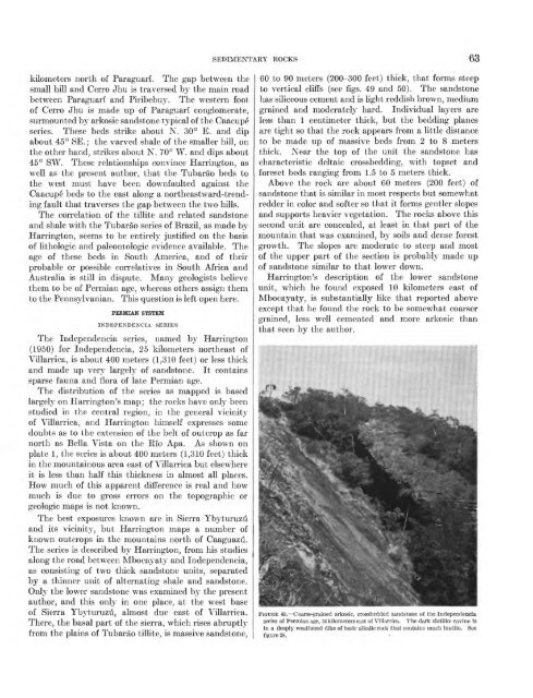
SEDIMENTARY ROCKS 63kilometers north <strong>of</strong> Paraguari. The gap between thesmall hill <strong>and</strong> Cerro Jhu is traversed by the main roadbetween Paraguari <strong>and</strong> Piribebuy. The western foot<strong>of</strong> Cerro Jhu is made up <strong>of</strong> Paraguari conglomerate,surmounted by arkosic s<strong>and</strong>stone typical <strong>of</strong> the Caacupeseries. These beds strike about N. 30° E. <strong>and</strong> dipabout 45° SE.; the varved shale <strong>of</strong> the smaller hill, onthe other h<strong>and</strong>, strikes about N. 70° W. <strong>and</strong> dips about45° SW. These relationships convince Harrington, aswell as the present author, that the Tubarao beds tothe west must have been downfaulted against theCaacupe beds to the east along a northeastward-trendingfault that traverses the gap between the two hills.The correlation <strong>of</strong> the tillite <strong>and</strong> related s<strong>and</strong>stone<strong>and</strong> shale with the Tubarao series <strong>of</strong> Brazil, as made byHarrington, seems to be entirely justified on the basis<strong>of</strong> lithologic <strong>and</strong> paleontologic evidence available. Theage <strong>of</strong> these beds in South America, <strong>and</strong> <strong>of</strong> theirprobable or possible correlatives in South Africa <strong>and</strong>Australia is still in dispute. Many geologists believethem to be <strong>of</strong> Permian age, whereas others assign themto the Pennsylvanian. This question is left open here.PERMIAN SYSTEMINDEPENDENCE SERIESThe Independencia series, named by Harrington(1950) for Independencia, 25 kilometers northeast <strong>of</strong>Villarrica, is about 400 meters (1,310 feet) or less thick<strong>and</strong> made up very largely <strong>of</strong> s<strong>and</strong>stone. It containssparse fauna <strong>and</strong> flora <strong>of</strong> late Permian age.The distribution <strong>of</strong> the series as mapped is basedlargely on Harrington's map; the rocks have only beenstudied in the central region, in the general vicinity<strong>of</strong> Villarrica, <strong>and</strong> Harrington himself expresses somedoubts as to the extension <strong>of</strong> the belt <strong>of</strong> outcrop as farnorth as Bella Vista on the Rio Apa. As shown onplate 1, the series is about 400 meters (1,310 feet) thickin the mountainous area east <strong>of</strong> Villarrica but elsewhereit is less than half this thickness in almost all places.How much <strong>of</strong> this apparent difference is real <strong>and</strong> howmuch is due to gross errors on the topographic orgeologic maps is not known.The best exposures known are in Sierra Ybyturuzu<strong>and</strong> its vicinity, but Harrington maps a number <strong>of</strong>known outcrops in the mountains north <strong>of</strong> Caaguazu.The series is described by Harrington, from his studiesalong the road between Mbocayaty <strong>and</strong> Independencia,as consisting <strong>of</strong> two thick s<strong>and</strong>stone units, separatedby a thinner unit <strong>of</strong> alternating shale <strong>and</strong> s<strong>and</strong>stone.Only the lower s<strong>and</strong>stone was examined by the presentauthor, <strong>and</strong> this only in one place, at the west base<strong>of</strong> Sierra Ybyturuzu, almost due east <strong>of</strong> Villarrica.There, the basal part <strong>of</strong> the sierra, which rises abruptlyfrom the plains <strong>of</strong> Tubarao tillite, is massive s<strong>and</strong>stone,60 to 90 meters (200-300 feet) thick, that forms steepto vertical cliffs (see figs. 49 <strong>and</strong> 50). The s<strong>and</strong>stonehas siliceous cement <strong>and</strong> is light reddish brown, mediumgrained <strong>and</strong> moderately hard. Individual layers areless than 1 centimeter thick, but the bedding planesare tight so that the rock appears from a little distanceto be made up <strong>of</strong> massive beds from 2 to 8 metersthick. Near the top <strong>of</strong> the unit the s<strong>and</strong>stone hascharacteristic deltaic crossbedding, with topset <strong>and</strong>foreset beds ranging from 1.5 to 5 meters thick.Above the rock are about 60 meters (200 feet) <strong>of</strong>s<strong>and</strong>stone that is similar in most respects but somewhatredder in color <strong>and</strong> s<strong>of</strong>ter so that it forms gentler slopes<strong>and</strong> supports heavier vegetation. The rocks above thissecond unit are concealed, at least in that part <strong>of</strong> themountain that was examined, by soils <strong>and</strong> dense forestgrowth. The slopes are moderate to steep <strong>and</strong> most<strong>of</strong> the upper part <strong>of</strong> the section is probably made up<strong>of</strong> s<strong>and</strong>stone similar to that lower down.Harrington's description <strong>of</strong> the lower s<strong>and</strong>stoneunit, which he found exposed 10 kilometers east <strong>of</strong>Mbocayaty, is substantially like that reported aboveexcept that he found the rock to be somewhat coarsergrained, less well cemented <strong>and</strong> more arkosic thanthat seen by the author.FIGURE 49. Coarse-grained arkosic, crossbedded s<strong>and</strong>stone <strong>of</strong> the Independenciaseries <strong>of</strong> Permian age, 13 kilometers east <strong>of</strong> Villarrica. The dark slotlike ravine isin a deeply weathered dike <strong>of</strong> basic alkalic rock that contains much biotite. Seefigure 28.