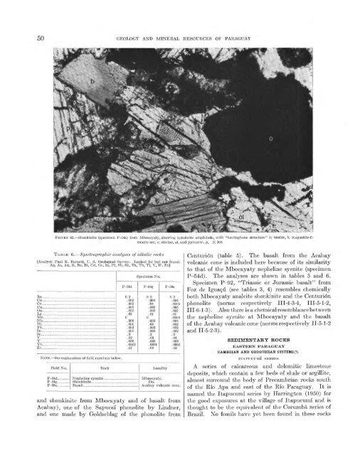
50 GEOLOGY AND MINERAL RESOURCES OF PARAGUAYFIGURE 42. Shonkinite (specimen P-54a) from Mbocayaty, showing kat<strong>of</strong>orite amphibole, with "herringbone structure" fc; biotite, 6; magnetite-ilmeniteore, o; olivine, ol, <strong>and</strong> pyroxene, p, X 300.TABLE 6. Spectrographic analyses <strong>of</strong> aikalic rocks[Analyst: Paul R. Barnett, U. S. Geological Survey. Looked for but not found:Ag, As, Au, B, Be, Bi, Cd, Oe, In, Pt, Sb, Sn, Ta, Th, Tl, V, W, Zn]Ba _. ____________OrCu ... ... .Ga .LaMoNbNi ... ... ... .....Pb._ ..............ScSr ................V .............YbZr_NOTE.See explanation <strong>of</strong> field numbers below.Field No.P-54d ....P-58a._- ...RockP-54d0.2.002.002.005.002.020 .008.001.003.001.3.02.006.0002.07Basalt- .. __ .. . .Specimen No.P-54g0.2.004.04.005.002.010 .005.03.003.002.2.03.005.0001.04LocalityP-58a0.2.004.0005.005.002.01.0004.004.002.002.002.2.04.009.0002.03Mbocayaty.Do.Acahay volcanic cone.<strong>and</strong> shonkinite from Mbocayaty <strong>and</strong> <strong>of</strong> basalt fromAcahay), one <strong>of</strong> the Sapucal phonolite by Lindner,<strong>and</strong> one made by Goldschlag <strong>of</strong> the phonolite fromCenturion (table 5). The basalt from the Acahayvolcanic cone is included here because <strong>of</strong> its similarityto that <strong>of</strong> the Mbocayaty nepheline syenite (specimenP-54d). The analyses are shown in tables 5 <strong>and</strong> 6.Specimen P-92, "Triassic or Jurassic basalt" fromFoz de Iguagu (see tables 3, 4) resembles chemicallyboth Mbocayaty analcite shonkinite <strong>and</strong> the Centurionphonolite (norms respectively IIL4-3-4, IIL5-1-2,III-6-1-3). Also there is a chemical resemblance betweenthe nepheline syenite at Mbocayaty <strong>and</strong> the basalt<strong>of</strong> the Acahay volcanic cone (norms respectively IL5-1-2<strong>and</strong>II-5-2-3).SEDIMENTARY BOCKSEASTERN PARAGUAYCAMBRIAN AND OEDOVICIAN SYSTEMS(?)ITAPUCUMI SERIESA series <strong>of</strong> calcareous <strong>and</strong> dolomitic limestonedeposits, which contain a few beds <strong>of</strong> shale or argillite,almost surround the body <strong>of</strong> Precambrian rocks south<strong>of</strong> the Rio Apa <strong>and</strong> east <strong>of</strong> the Rio <strong>Paraguay</strong>. It isnamed the Itapucumi series by Harrington (1950) forthe good exposures at the village <strong>of</strong> Itapucumi <strong>and</strong> isthought to be the equivalent <strong>of</strong> the Corumba series <strong>of</strong>Brazil. No fossils have yet been found in these rocks
SEDIMENTARY ROCKS 51<strong>and</strong>, in view <strong>of</strong> differences <strong>and</strong> fairly frequent changesin the opinions <strong>of</strong> geologists as to the ages <strong>of</strong> theserocks <strong>and</strong> <strong>of</strong> their supposed equivalents in Brazil <strong>and</strong>Bolivia, no closer age assignment than that <strong>of</strong>Cambrian (?) <strong>and</strong> Ordovician(?) seems justified.The distribution <strong>of</strong> the series <strong>and</strong> the attitudesymbols, as shown on plate 1, are based on ground<strong>and</strong> air observations by the author along the Rio<strong>Paraguay</strong>, particularly in the vicinity <strong>of</strong> the Vallemicement plant, on his interpretations <strong>of</strong> aerial photographs,<strong>and</strong> on various published observations byCarnier (1911c), Kanter (1936), Boettner (1947) <strong>and</strong>Harrington (1950). Several relatively small outliers<strong>of</strong> the Itapucumi series rise from the alluvium along<strong>and</strong> near the Gran Chaco side <strong>of</strong> the Rio <strong>Paraguay</strong>.Most <strong>of</strong> them form low rounded hills scarcely morethan 5 to 10 meters high, but the largest one, CerroGalban, just southwest <strong>of</strong> Puerto Casado, rises 140meters above the swampy plain <strong>and</strong> is about onekilometer long. It is sketched <strong>and</strong> described by Krieg(1931) as made up almost entirely <strong>of</strong> limestone, witha small hillock <strong>of</strong> red s<strong>and</strong>stone near its eastern end.The limestone from the main hill, which is quarried forvarious uses at Puerto Casado, is dark blue gray <strong>and</strong>crystalline.The series is almost continuously exposed along theeast bank <strong>of</strong> the Rio <strong>Paraguay</strong> from near San Salvadorto the mouth <strong>of</strong> the Rio Apa (pi. 1). Over much <strong>of</strong>this distance there are conspicuous cliffs 15 to 20meters high (figs. 21 <strong>and</strong> 23), backed by rounded <strong>and</strong>heavily forested hills that are 100 to 200 meters high.Eastward from the river the limestone is more or lesscontinuously exposed as far as the Apa highl<strong>and</strong>, in thevicinities <strong>of</strong> Cerro Paiba <strong>and</strong> Loma Pora. There theywere seen by Carnier (191 Ic) to rest on or against olderPrecambrian rocks, unconformably in some places <strong>and</strong>in fault contact in others. The belt trends southwardaround the end <strong>of</strong> the Precambrian body but is apparentlynot well exposed there for it is not describedby any investigators. It reappears along the eastside <strong>of</strong> the Precambrian rocks, where it is described<strong>and</strong> sketched by Boettner (1947) between ArroyoYtaguy <strong>and</strong> Arroyo Hermosa.The Itapucumi series is thought by Harrington(1950) to be about 300 to 400 meters thick. This isonly an approximation, however, since no detailedmapping has been done <strong>and</strong> the general pattern <strong>of</strong>folding, indicated on plate 1 by scattered observations<strong>of</strong> attitude, has yet to be worked out.Figure 43 shows the character <strong>of</strong> the limestone <strong>and</strong>a description <strong>of</strong> the rocks exposed in the Vallemiquarry is given in the section on cement. In general,the series is made up <strong>of</strong> light- to dark-gray limestonein well-defined, relatively thin beds. Locally the bedsare thick <strong>and</strong> massive, alternating with shaly limestone<strong>and</strong> marly shale. All the rocks are hard <strong>and</strong> dense <strong>and</strong>most <strong>of</strong> them are fine grained, but some are partly orentirely recrystallized <strong>and</strong> cut by veins <strong>of</strong> calcite ordolomite. Oolitic <strong>and</strong> lithographic limestone, as wellas various kinds <strong>of</strong> green- <strong>and</strong> pink-toned marble havebeen reported from a number <strong>of</strong> places.The rocks range from nearly pure limestone with 95percent or more calcium carbonate to nearly puredolomite. The analyses below are believed to befairly representative. As noted on page 80, the purerlimestone at Vallemi contains approximately 95percent calcium carbonate, whereas the varieties thatare streaked green by chloritic material contain 80 to85 percent calcium carbonate.Analyses <strong>of</strong> typical limestones <strong>of</strong> Itapucumi seriesCaO ___ ____ __ _____ ______MgO_-_ - _- _-(Fe, A1) 2O3_-- _ __ _______H 2O___ __ _____ ___ ___ ___ _CO2_______ ___ ____ __ ________[M. Goldschlag (1913c), analyst]13.3450.900.932.971.7540.98100. 9523.9052.691.9741.300.69100.5531.1252.853.030.3642.2099.6643.3830.9117.942.541.8543.79100.41NOTE. Explanation <strong>of</strong> localities <strong>of</strong> samples:1. Limestone, Cordillera de las Quince Puntas, 10 kilometers west-northwest <strong>of</strong>Centurion.2. Oolitic limestone, 35 kilometers north-northwest <strong>of</strong> Puerto Max on Rio<strong>Paraguay</strong> (near Puerto Fonciere).3. Limestone, Cerro Paiba, 10 kilometers southwest <strong>of</strong> San Carlos.4. Dolomitic limestone, left bank <strong>of</strong> Rio La Paz, east <strong>of</strong> San Luis de la Sierra.The limestone series rests uncomformably on the Precambrianbasement rocks that make up the PotreroSaty. They are shown on plate 1 as everywhere overlaindirectly by the Tubarao series <strong>of</strong> Pennsylvanian orPermian age but only in the extreme northeastern part<strong>of</strong> their belt <strong>of</strong> outcrop, near Santa Luisa, is this contactactually known. Not far from the town <strong>of</strong> Santa Luisa,<strong>and</strong> along Arroyo Hermosa, Boettner (1947) found tillite<strong>of</strong> the Tubarao beds, with striated pebbles, resting onthe Itapucumi limestone.It appears certain that the Itapucumi beds do not extendfar into southern <strong>Paraguay</strong>, because Silurian <strong>and</strong>younger beds rest directly on the Precambrian basementin many places farther south. According to availableknowledge, none <strong>of</strong> the wells drilled by the Union OilCompany were deep enough to have reached these beds,so it is not known whether the Itapucumi rocks extendbeneath the Gran Chaco. Quite possibly they do not,for no rocks <strong>of</strong> similar character seem to be known in theeastern Andes, where the deeper beds <strong>of</strong> the Gran Chacobasin reappear at the surface (Ahlfeld, 1946, geologicmap).Boettner (1947) notes that marble was once quarriedat Puerto Max for ornamental stone <strong>and</strong> DuGraty