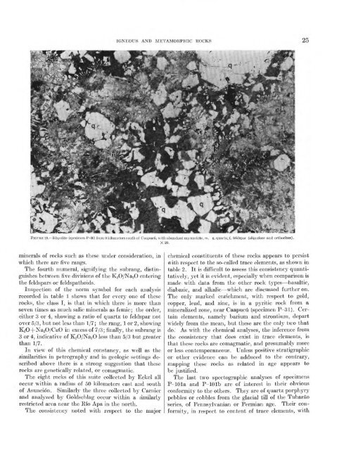
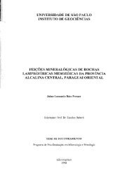
25FIGURE 18. Ehyolite (specimen P-30) from 9 kilometers south <strong>of</strong> Caapucu, with abundant myrmekite, m. g, quartz;/, feldspar (oligoclase <strong>and</strong> orthoclase).X20.minerals <strong>of</strong> rocks such as these under consideration, inwhich there are five rangs.The fourth numeral, signifying the subrang, distinguishesbetween .five divisions <strong>of</strong> the K^O/NaaO enteringthe feldspars or feldspathoids.Inspection <strong>of</strong> the norm symbol for each analysisrecorded in table 1 shows that for every one <strong>of</strong> theserocks, the class I, is that in which there is more thanseven times as much salic minerals as femic; the order,either 3 or 4, showing a ratio <strong>of</strong> quartz to feldspar notover 5/3, but not les^ than 1/7; the rang, 1 or 2, showingK2O+Na2O/CaO in excess <strong>of</strong> 7/3; finally, the subrang is3 or 4, indicative <strong>of</strong> K2O/Na2O less than 5/3 but greaterthan 1/7.In view <strong>of</strong> this chemical constancy, as well as thesimilarities in petrography <strong>and</strong> in geologic settings describedabove there is a strong suggestion that theserocks are genetically related, or comagmatic.The eight rocks <strong>of</strong> this suite collected by Eckel alloccur within a radius <strong>of</strong> 50 kilometers east <strong>and</strong> south<strong>of</strong> Asuncion. Similarly the three collected by Carnier<strong>and</strong> analyzed by Goldschlag occur within a similarlyrestricted area near the Rio Apa in the north.The consistency noted with respect to the majorchemical constituents <strong>of</strong> these rocks appears to persistwith respect to the so-called trace elements, as shown intable 2. It is difficult to assess this consistency quantitatively,yet it is evident, especially when comparison ismade with data from the other rock t^^pes basaltic,diabasic, <strong>and</strong> alkalic which are discussed further on.The only marked enrichment, with respect to gold,copper, lead, <strong>and</strong> zinc, is in a pyritic rock from amineralized zone, near Caapucu (specimen P-31). Certainelements, namely barium <strong>and</strong> strontium, departwidely from the mean, but these are the only two thatdo." As with the chemical analyses, the inference fromthe consistency that does exist in trace elements, isthat these rocks are comagmatic, <strong>and</strong> presumably moreor less contemporaneous. Unless positive stratigraphicor other evidence can be adduced to the contrary,mapping these rocks as related in age appears tobe justified.The last two spectographic analyses <strong>of</strong> specimensP-lOla <strong>and</strong> P-lOlb are <strong>of</strong> interest in their obviousconformity to the others. They are <strong>of</strong> quartz porphyrypebbles or cobbles from the glacial till <strong>of</strong> the Tubaraoseries, <strong>of</strong> Penns\lvanian or Permian age. Their conformity,in respect to content <strong>of</strong> trace elements, with
26 GEOLOGY AND MINERAL RESOURCES OF PARAGUAYthe other rocks shown in the table, suggests that theglaciers <strong>of</strong> Pennsylvanian or Permian time derived theirpebbles, or some <strong>of</strong> them, from outcrops <strong>of</strong> Precambrianrocks similar to those that are now exposed in southern<strong>Paraguay</strong> <strong>and</strong> in the Apa region.GENEKAL FEATUKESThe entire eastern <strong>and</strong> southeastern side <strong>of</strong> <strong>Paraguay</strong>is blanketed by basaltic lavas. The name Serra Geralis adopted by Harrington (1950) <strong>and</strong> for this reportfrom current usage in Brazil (Oliveira <strong>and</strong> Leonardos,1943, p. 499). Of Late Triassic or Jurassic age, theserocks constitute the westerly fringe <strong>of</strong> the great basaltfield <strong>of</strong> the Parana basin, which, as Baker (1923) pointsout, covers an area <strong>of</strong> 800,000 square kilometers inBrazil, <strong>Paraguay</strong>, Argentina, <strong>and</strong> Uruguay, <strong>and</strong> isnearly as large as the Deccan <strong>and</strong> Columbia Plateaulava fields combined. Oliveira <strong>and</strong> Leonardos (1943)ascribe an even larger area to the Serra Geral lavas1.2 million square kilometers, <strong>of</strong> which 900,000 squarekilometers are in Brazil.The Serra Geral lavas are typical plateau-type basalts,with no known pyroclastic features or other evidence<strong>of</strong> explosive activity; the consensus seems to be thatthe magma rose quietly along fissures in various parts<strong>of</strong> the basin. They may possibly be related to thedikes, flows, <strong>and</strong> other bodies <strong>of</strong> basic alkalic igneousrocks that occur in other parts <strong>of</strong> <strong>Paraguay</strong>. Evenmore probably, they may be closely related to theintrusive diabasic rocks that are known in a number <strong>of</strong>places.The only exposures <strong>of</strong> the Serra Geral lavas thatwere actually examined by Eckel are in the valley <strong>of</strong>the Rio Parana, near the town <strong>of</strong> Foz de Iguagu (spelledIguassu on <strong>Paraguay</strong>an maps <strong>and</strong> either Iguassii orIguazii on Argentine maps) on the Brazilian side <strong>of</strong>the Parana. This small port town is the gateway tothe Brazilian Parque Nacional de Iguagu that surroundsthe spectacular cataracts on the Rio Iguagu<strong>and</strong> which are also called Foz de Iguagu on some maps.To avoid confusion, the falls are here called the "Iguagufalls" whereas the name "Foz de Iguagu" refers to thetown, which is about 20 kilometers west <strong>of</strong> the falls<strong>and</strong>, as its name implies, is near the mouth <strong>of</strong> the RioIguagu.The specimens collected by Eckel at Foz de Iguagushow an alkalic character that may possibly be anexceptional feature <strong>of</strong> the Serra Geral lavas. Oneother specimen <strong>of</strong> the Serra Geral rocks, specimen P-14,from about 200 kilometers southwest <strong>of</strong> Foz de Iguaguwas also obtained <strong>and</strong> is described on p. 30.A good idea <strong>of</strong> the extent <strong>and</strong> geomorphologic character<strong>of</strong> the basaltic terrain in the upl<strong>and</strong>s was gainedby air views along several flight lines. The distribution<strong>of</strong> the lavas shown on plate 1 is probably moreaccurate than that <strong>of</strong> most other map units becausethe streams that drain the lava-covered areas followangular courses that are almost certainly controlled bytwo or more intersecting joint systems in the underlyingbasalt. By interpreting stream forms as shownon air photographs <strong>and</strong> on large scale base maps it waspossible to add appreciably to the detail <strong>of</strong> the map byHarrington (1950) without direct field observation.Although the characteristic stream drainage pattern islargely lost on a map at the scale <strong>of</strong> plate 1, it is clearlyshown on the 1:500,000 scale U. S. Air Force chartsfrom which plate 1 was compiled; on these charts thereis an abrupt change in the pattern <strong>of</strong> virtually everystream as it leaves the sedimentary rocks farther east<strong>and</strong> enters the lava-covered area. The westerly contact<strong>of</strong> the lavas, therefore, is drawn to connect thesechanges in stream pattern.The Serra Geral lavas once extended fai west <strong>and</strong>south <strong>of</strong> their present outcrops in the northern pampas<strong>of</strong> Argentina. This is shown by their discovery inseveral deep borings in Santiago del Estero <strong>and</strong>Santa Fe provinces. Within <strong>Paraguay</strong>, however,it seems probable that the lavas never extended muchfarther west than is indicated by their present distribution,taking account <strong>of</strong> the few outliers that lie west <strong>of</strong>the main body. That they never reached the GranChaco region is clearly indicated by the absence <strong>of</strong>basalt or basaltic debris in any <strong>of</strong> the five exploratoryholes that were drilled there. Moreover, even thoughthe lavas are rather deeply weathered on the upl<strong>and</strong>swest <strong>of</strong> the Rio Parana, they are far more resistant toerosion than most <strong>of</strong> the sedimentary rocks. It seemsreasonable to suppose, then, that if they ever coveredthose rocks west <strong>of</strong> their present outcrop they wouldhave protected the latter from erosion to the presentday.The lavas, called trap, dolerite, basalt, diabase,melaphyr, <strong>and</strong> other terms by various authors, rangefrom <strong>and</strong>esite <strong>and</strong> augite porphyrite to typical limburgitewith abundant olivine (Baker, 1923); in <strong>Paraguay</strong>,judging from published accounts, basalt with little orno olivine (tholeitic basalt) appears to be the predominantkind.As seen in the vicinity <strong>of</strong> Foz de Iguagu (figs. 19 <strong>and</strong>20), individual flows range from less than 1 to 4 metersthick; at Iguagu falls, a few kilometers east <strong>of</strong> the town,some flows are 10 or more meters thick. The rocks inthe different flows vary widely in appearance, but thisis due more to differences in structure <strong>and</strong> porosity thanto composition. Many, if not most, flows are stronglyamygdaloidal, others are massive, <strong>and</strong> a few show