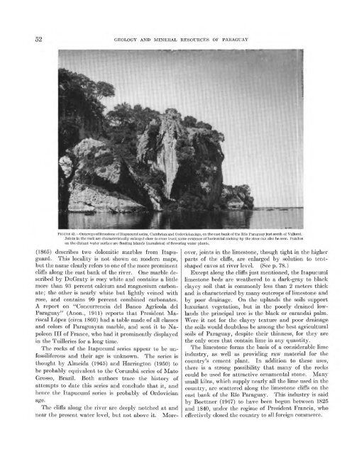
52 GEOLOGY AND MINERAL RESOURCES OF PARAGUAYFIGURE 43. Outcrops <strong>of</strong> limestone <strong>of</strong> Itapucumi series, Cambrian <strong>and</strong> Ordovician age, on the east bank <strong>of</strong> the Rio <strong>Paraguay</strong> just south <strong>of</strong> Valleml.Joints in the rock are characterisically enlarged close to river level; some evidence <strong>of</strong> horizontal niching by the river can also be seen. Patcheson the distant water surface are floating isl<strong>and</strong>s (camalotes) <strong>of</strong> flowering water plants.(1865) describes two dolomitic marbles from Itapuguazu.This locality is not shown on modern maps,but the name clearly refers to one <strong>of</strong> the more prominentcliffs along the east bank <strong>of</strong> the river. One marble describedby DuGraty is rosy white <strong>and</strong> contains a littlemore than 93 percent calcium <strong>and</strong> magnesium carbonate;the other is nearly white but lightly veined withrose, <strong>and</strong> contains 99 percent combined carbonates.A report on "Concurrencia del Banco Agricola del<strong>Paraguay</strong>" (Anon., 1911) reports that President MariscalLopez (circa 1860) had a table made <strong>of</strong> all classes<strong>and</strong> colors <strong>of</strong> <strong>Paraguay</strong>an marble, <strong>and</strong> sent it to NapoleonIII <strong>of</strong> France, who had it prominently displayedin the Tuilleries for a long time.The rocks <strong>of</strong> the Itapucumi series appear to be unfossiliferous<strong>and</strong> their age is unknown. The series isthought by Almeida (1945) <strong>and</strong> Harrington (1950) tobe probably equivalent to the Corumba series <strong>of</strong> MatoGrosso, Brazil. Both authors trace the history <strong>of</strong>attempts to date this series <strong>and</strong> conclude that it, <strong>and</strong>hence the Itapucumi series is probably <strong>of</strong> OrdovicianThe cliffs along the river are deeply notched at <strong>and</strong>near the present water level, but not above it. Moreover,joints in the limestone, though tight in the higherparts <strong>of</strong> the cliffs, are enlarged by solution to tentshapedcaves at river level. (See p. 78.)Except along the cliffs just mentioned, the Itapucumilimestone beds are weathered to a dark-gray to blackclayey soil that is commonly less than 2 meters thick<strong>and</strong> is characterized by many outcrops <strong>of</strong> limestone <strong>and</strong>by poor drainage. On the upl<strong>and</strong>s the soils supportluxuriant vegetation, but in the poorly drained lowl<strong>and</strong>sthe principal tree is the black or car<strong>and</strong>ai palm.Were it not for the clayey texture <strong>and</strong> poor drainagethe soils would doubtless be among the best agriculturalsoils <strong>of</strong> <strong>Paraguay</strong>, despite their thinness, for they arethe only ones that contain lime in any quantity.The limestone forms the basis <strong>of</strong> a considerable limeindustry, as well as providing raw material for thecountry's cement plant. In addition to these uses,there is a strong possibility that many <strong>of</strong> the rockscould be used for attractive ornamental stone. Manysmall kilns, which supply nearly all the lime used in thecountry, are scattered along the limestone cliffs on theeast bank <strong>of</strong> the Rio <strong>Paraguay</strong>. This industry is saidby Boettner (1947) to have been begun between 1825<strong>and</strong> 1840, under the regime <strong>of</strong> President Francia, whoeffectively closed the country to all foreign commerce.
SEDIMENTARY ROCKS 53SILURIAN SYSTEMCAACUPE SERIESThe Caacupe series, at least 700 meters (2,300 feet)thick, consists largely <strong>of</strong> arkosic s<strong>and</strong>stone with a basalconglomerate <strong>and</strong> with some beds <strong>of</strong> clay <strong>and</strong> shale.Fossil evidence shows it to be <strong>of</strong> Early Silurian age.The probable correlatives <strong>of</strong> these beds in the GranChaco basin, as determined by deep exploratory wells<strong>and</strong> as described in another section in this report, arelargely black marine shale with comparatively littles<strong>and</strong>stone.As shown on plate 1, the Caacupe series occupiesmuch <strong>of</strong> the heavily populated west central part <strong>of</strong> thecountry extending southward from the banks <strong>of</strong> theRio <strong>Paraguay</strong> above Asuncion to Quiindy <strong>and</strong> Mbuyapey<strong>and</strong> from Ypacarai eastward to the longitude <strong>of</strong>Eusebio Ayala.The Caacupe series can be divided into four lithologicunits, as follows:ApproximatethicknessTop.1. S<strong>and</strong>stone, red to brown, massive, fossiliferous; highlymicaceous in part; underlain by s<strong>of</strong>t light-coloredshale or clay with thin beds <strong>of</strong> s<strong>and</strong>stone. _________ 2002. S<strong>and</strong>stone, white, saccharoidaL _ __________________ 1003. S<strong>and</strong>stone, brown to red-brown, fine- to coarse-grained,arkosic; several f ossilif erous clayey horizons nearbase._________________________________________ 4004. Basal Paraguari conglomerate. _____________________ 1-50These units, which are described below, cannot beshown separately on plate 1, but more detailed geologicstudies will almost certainly prove them to be easilymappable units that may ultimately deserve the status<strong>of</strong> formations or members. It is also possible that theupper unit may be subdivisible into a lower shaly unit<strong>and</strong> an upper one <strong>of</strong> s<strong>and</strong>stone.Paraguari conglomerate. The lowest unit <strong>of</strong> theseries is a basal conglomerate that grades both laterally<strong>and</strong> upward to conglomeratic s<strong>and</strong>stone. It wasnamed the Paraguari conglomerate by Harrington(1950) for the excellent exposures just northeast <strong>of</strong> thattown. There it is 40 to 50 meters thick, but elsewhereit appears to be thinner <strong>and</strong> is probably no more than2 or 3 meters thick in most places. The conglomeraterests unconformably on the weathered surfaces <strong>of</strong> thePrecambrian rocks <strong>and</strong> is overlain gradationally bycoarse-grained crossbedded s<strong>and</strong>stone. According toHarrington, it is exposed along the entire length <strong>of</strong> theYpacarai depression, from San Bernardino to Paraguari,at the foot <strong>of</strong> the Cordillera de los Altos thatforms its eastern side. Harrington, who thinks that aconglomerate at Pirayu, on the west side <strong>of</strong> the depression,may belong to this unit, also mentions theexposures farther south that are described below.The typical conglomeratic rock consists <strong>of</strong> a greatnumber <strong>of</strong> pebbles in a coarse-grained s<strong>and</strong>y matrix.The pebbles are smooth, ellipsoidal to well-rounded,<strong>and</strong> 1 to 30 centimeters in diameter. They consistexclusively <strong>of</strong> siliceous materials vein quartz, quartzite,<strong>and</strong> various forms <strong>of</strong> chert <strong>and</strong> jasper. There areno igneous <strong>and</strong> metamorphic rocks except quartzite.The most easily studied exposure <strong>of</strong> the conglomerateis probably that at the north edge <strong>of</strong> San Bernardino.a resort town on the east shore <strong>of</strong> Lago Ypacarai.Even here the actual contact with underlying rocks ispoorly exposed. The lower part <strong>of</strong> a small hill at SanBernardino is made up <strong>of</strong> coarse Precambrian granite,fresh near the lake level, but strongly weathered <strong>and</strong>crumbly upward. The top <strong>of</strong> the hill is made up <strong>of</strong>coarse-grained brown to red-brown s<strong>and</strong>stone, at least7 meters thick. It is strongly crossbedded <strong>and</strong> containsmany thin lenses <strong>of</strong> conglomerate with pebbles1 to 2 centimeters in diameter. Between the weatheredgranite <strong>and</strong> the conglomeratic s<strong>and</strong>stone there is acovered interval less than 6 meters thick. The soil<strong>and</strong> slope wash in this interval, as well as on the uppermostpart <strong>of</strong> the granite slopes, contain an abundance olpebbles, 2 to 10 centimeters in diameter, <strong>of</strong> quartz,chert, <strong>and</strong> quartzite. These indicate that at least apart <strong>of</strong> the interval is made up <strong>of</strong> a true basal conglomerate,though it seems probable that even here there isa considerable amount <strong>of</strong> s<strong>and</strong>stone matrix.The basal conglomerate is well exposed in manyplaces along the highway between Quiindy <strong>and</strong> Caapucu,at Quyquy6, south <strong>of</strong> Acahay, <strong>and</strong> elsewhere.At all <strong>of</strong> these places it marks the contact betweenPrecambrian igneous <strong>and</strong> metamorphic rocks <strong>and</strong>erosional remnants <strong>of</strong> the lower part <strong>of</strong> the Caacupeseries. Nowhere in this southerly area does theconglomeratic horizon appear to be much more thanone meter thick. It grades upward to typical brownor red-brown s<strong>and</strong>stone <strong>of</strong> the Caacupe, <strong>and</strong> itsweathered surfaces are liberally strewn with roundedto semirounded pebbles <strong>of</strong> quartz, quartzite, <strong>and</strong>varicolored chert. As elsewhere, pebbles <strong>of</strong> granite<strong>and</strong> quartz porphyry, that form the surface on whichthe conglomerate was deposited are conspicuouslyabsent in the conglomerate.Arkosic s<strong>and</strong>stone. The arkosic s<strong>and</strong>stone, whichmakes up more than half <strong>of</strong> the Caacupe series, constitutesthe bulk <strong>of</strong> the rocks that are called the Piribebuys<strong>and</strong>stone by Harrington. It grades downwardto the basal conglomerate <strong>of</strong> the series <strong>and</strong> is overlain,with little or no gradation, by the thick white saccharoidals<strong>and</strong>stone unit. The unit consists almost