GEOGRAPHY 9thorny semidesert plants that are adapted to alternations<strong>of</strong> severe droughts <strong>and</strong> prolonged wet seasonswhen almost all <strong>of</strong> the surface <strong>of</strong> the Gran Chaco isswampy or actually covered by water. Scatteredthrough the brush forests are various hardwoods; alongtheir edges are groves <strong>of</strong> black palm (car<strong>and</strong>ai), somemany square kilometers in extent (fig. 2).TRANSPORTATION<strong>Paraguay</strong> is severely h<strong>and</strong>icapped in its development<strong>and</strong> in international commerce by its inl<strong>and</strong> location,which necessitates travel through neighboring countriesfor access to ocean transport. Its international commercedepends largely on facilities that are owned <strong>and</strong>controlled by foreign governments or corporations.Even so, the international transportation situation isbetter than the domestic one.Within the country, all the usual forms <strong>of</strong> transportationwater, rail, air, <strong>and</strong> road are represented butall are inadequate for the present needs <strong>of</strong> the country<strong>and</strong> will, unless improved greatly, hinder its developmentin future.By far the greater part <strong>of</strong> the country's internationaltrade, <strong>and</strong> a considerable part <strong>of</strong> its internal trade, iscarried by water. Between 1941 <strong>and</strong> 1950, more than87 percent <strong>of</strong> total exports were moved by river, nearlyall <strong>of</strong> the remainder going on the one international railroadthat links <strong>Paraguay</strong> with Buenos Aires. Truckshipments to <strong>and</strong> from Brazil <strong>and</strong> Argentina are negligible,but substantial contrab<strong>and</strong> movements <strong>of</strong> cattleon the ho<strong>of</strong> are generally believed to take place regularly.The <strong>Paraguay</strong>-Parana river system, comparable inmost respects to the Mississippi, is the main avenue <strong>of</strong>commerce. Its channel accommodates ships with9-foot draft during periods <strong>of</strong> normal flow, but this isdecreased to 7-foot draft during low water. The AltoParana, the only other stream that can be used forregular navigation, is shallower than the <strong>Paraguay</strong> <strong>and</strong>requires smaller craft. Asuncion, Conception, Villeta,Pilar, <strong>and</strong> Encarnacion are the main ports. Of these,only Asuncion has modern port facilities; even here logsmust be floated out to waiting ships <strong>and</strong> lifted from thewater by cranes or made up into rafts.More than 200 vessels, most <strong>of</strong> them old wood-firedships <strong>and</strong> barges originally designed for ocean travel,<strong>and</strong> <strong>of</strong> Argentine registry, serve the country's international transport needs. Most <strong>of</strong> them connectAsuncion with Buenos Aires, 1,600 river kilometers tothe south, but a few move 1,100 kilometers up-river toCorumba, Brazil.Shipping rates for the trip from Asuncion to BuenosAires range from 4 percent <strong>of</strong> the f. o. b. value <strong>of</strong> somemeat products to 86 percent <strong>of</strong> that for some timberproducts. A surcharge <strong>of</strong> 50 percent is commonlyadded during periods <strong>of</strong> low water, which sometimeslast more than 6 months.In addition to the international commerce describedabove, there is a large internal water traffic. Most <strong>of</strong>this is limited to the many ports along the <strong>Paraguay</strong><strong>and</strong> Alto Parana rivers, but there is some movement<strong>of</strong> goods on the smaller tributary rivers.A British-owned st<strong>and</strong>ard-gage railroad connectsAsuncion, Villarrica, Encarnacion, <strong>and</strong> many smallertowns along its route with Buenos Aires. It providesregular freight <strong>and</strong> passenger service but outwornwood-burning equipment <strong>and</strong> poorly maintained trackagecause delays at times. A number <strong>of</strong> other railroadsare shown on plate 1. All are privately owned narrowgagelines, used principally for moving <strong>of</strong> forestproducts.Several foreign airlines provide regular passenger,mail, <strong>and</strong> freight service between Asuncion <strong>and</strong> Riode Janeiro, Montevideo, Buenos Aires, Santiago, LaPaz, <strong>and</strong> Lima. All but Lima are only 4 to 5 hours'flight time from Asuncion. One Argentine company useshydroplanes that operate from the Asuncion harbor;all the other companies use the national airport, whichhas a single, asphalt-paved runway on the outskirts <strong>of</strong>Asuncion. Aside from, a few privately owned planes,all internal air transportation is by a governmentcontrolledcompany, which uses small 1 to 3 passengeraircraft <strong>and</strong> <strong>Paraguay</strong>an Air Force pilots. Most <strong>of</strong> thetowns, as well as many private ranches, have earth orgrass l<strong>and</strong>ing strips. Any <strong>of</strong> these can be reachedwithin about 3 hours' flying time from Asuncion,though there are likely to be many delays, due toweather <strong>and</strong> other factors, in obtaining passage.Moreover, many <strong>of</strong> the l<strong>and</strong>ing strips are likely to beunserviceable during parts <strong>of</strong> every year because <strong>of</strong>rain, mud, or overflow from nearby streams.Within the country, most travel <strong>and</strong> transport <strong>of</strong>goods are by roads <strong>and</strong> cart tracks. At the end <strong>of</strong>1951 there were about 5,000 automotive vehicles inthe country; nearly four-fifths <strong>of</strong> them were registeredin the capital city. Of the total, about half werepassenger automobiles <strong>and</strong> half were trucks or buses.Horses with light wagons are used extensively in afew <strong>of</strong> the colonies settled by Europeans, but the greatbulk <strong>of</strong> overl<strong>and</strong> transportation throughout the countryis done by oxen. In 1943 there were 27,000 carretastwo-wheeled heavy carts drawn by one to six oxen inuse by farmers alone, plus an unknown but largeadditional number in the forest industries.The principal road net is shown on plate 1. Asidefrom some <strong>of</strong> the streets in Asuncion <strong>and</strong> a few blocksin Encarnacion <strong>and</strong> Villarrica, the only paved, allweatherhighway in the country extends eastward from
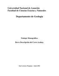
10 GEOLOGY AND MINERAL RESOURCES OF PARAGUAYAsuncion to Eusebio Ayala, a distance <strong>of</strong> 73 kilometers(45 miles). In addition to this two-lane, asphaltsurfacedhighway there are nearly 965 kilometers (600miles) <strong>of</strong> graded <strong>and</strong> maintained highways, abouttwo-thirds <strong>of</strong> them gravel surfaced. Except for thelack <strong>of</strong> bridges in places, most <strong>of</strong> these roads areexcellent during fine weather; it is both illegal <strong>and</strong>virtually impossible to traverse any <strong>of</strong> them for a period<strong>of</strong> 24 hours after each rain.There are also many thous<strong>and</strong> miles <strong>of</strong> unimprovedroads <strong>and</strong> cart tracks throughout the country. Onlya few are shown on plate 1, <strong>and</strong> fewer yet can be easilytraveled by other than oxen or specially sturdy automotivevehicles, even in dry weather.POPULATIONAccording to the 1950 census, the total population <strong>of</strong><strong>Paraguay</strong> was 1,405,627, or an average <strong>of</strong> 3.5 personsper square kilometer (0.7 per square mile). This is thelowest population density in South America <strong>and</strong> amongthe lowest in the world. As indicated by figure 4, thepopulation is very unevenly distributed. In fact,96 percent <strong>of</strong> the people live east <strong>of</strong> the Rio <strong>Paraguay</strong><strong>and</strong> more than half occupy only 4 percent <strong>of</strong> the l<strong>and</strong>in Asuncion <strong>and</strong> nearby departments.The <strong>Paraguay</strong>an people are predominantly a homogeneousmixture <strong>of</strong> Spanish <strong>and</strong> Guarani Indian.Spanish is the <strong>of</strong>ficial language but outside Asunci6n<strong>and</strong> even within it to considerable extent, Guarani isfar more widely used than Spanish.There are a total <strong>of</strong> about 40,000 indigenous Indiansbelonging to about 30 different family <strong>and</strong> linguisticgroups. Nearly all <strong>of</strong> them lead nomadic lives in theGran Chaco; a few work for timber companies or forfarmers.The 1950 census showed that there were 38,000foreign nationals in <strong>Paraguay</strong>, representing a score <strong>of</strong>countries, but largely from central Europe. Nearlyall are religious, political, or economic refugees who havecome to <strong>Paraguay</strong> since 1900. Offered asylum, aswell as l<strong>and</strong>s, by <strong>Paraguay</strong>, they are largely settled inisolated colonies, particularly in the central GranChaco, in the area southeast <strong>of</strong> Conception, <strong>and</strong> in theMisiones region along the Rio de Alto Par<strong>and</strong> nearEncarnacion. To date there has been little tendencytoward social or economic mixing between the immigrant<strong>and</strong> <strong>Paraguay</strong>an populations.INDUSTRIES<strong>Paraguay</strong> depends almost entirely on agriculture,livestock, <strong>and</strong> forest products for its economic existence.Local industries are largely limited to partial processing<strong>of</strong> these products for export; nearly all manufacturedgoods are imported. One indirect result <strong>of</strong> the heavy(URUGUAY \ ~"FIGURE 4. Density <strong>of</strong> population, <strong>Paraguay</strong>, 1950, compiled from data in the flies<strong>of</strong> the Institute <strong>of</strong> Inter-American Affairs, Asuncion.dependence on food growing is that the people are wellfed, with a calorie intake per capita <strong>of</strong> 2,813 per dayas compared with 3,098 calories in the United States.On the other h<strong>and</strong>, the money income per capita isone <strong>of</strong> the lowest in the world, amounting to less than$40 in United States money per year in 1950.Four percent <strong>of</strong> the total l<strong>and</strong> is in farms, but lessthan one percent is actually under cultivation. Allbut about 10 percent <strong>of</strong> the farmers have less than20 hectares (50 acres) per farm. Of the remainingl<strong>and</strong>, 40 percent is devoted to grazing, 54 percent isforested, <strong>and</strong> 2 percent is classed as wastel<strong>and</strong>.Exports in 1950, which were approximately balancedby imports, were valued at 167.4 million guaranies, or18.6 million United States dollars at the then average<strong>of</strong>ficial rate <strong>of</strong> exchange for exports. Forest products,