Orestimba Creek Hydrology - Stanislaus County
Orestimba Creek Hydrology - Stanislaus County
Orestimba Creek Hydrology - Stanislaus County
- No tags were found...
You also want an ePaper? Increase the reach of your titles
YUMPU automatically turns print PDFs into web optimized ePapers that Google loves.
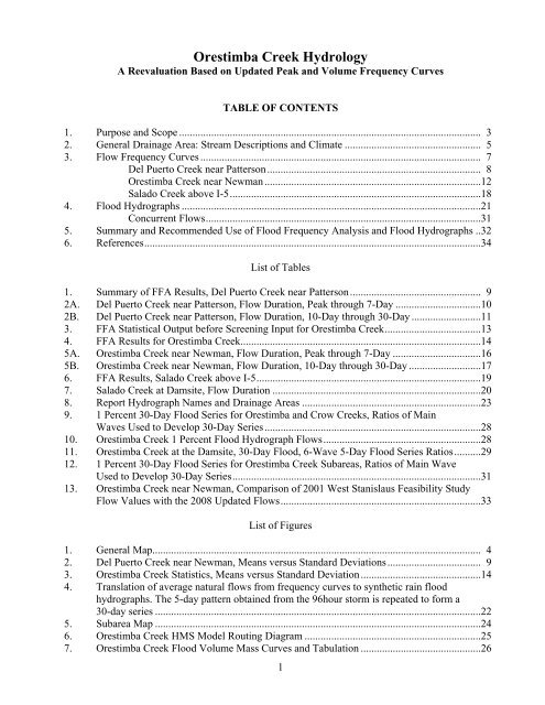
<strong>Orestimba</strong> <strong>Creek</strong> <strong>Hydrology</strong>A Reevaluation Based on Updated Peak and Volume Frequency CurvesTABLE OF CONTENTS1. Purpose and Scope ................................................................................................................. 32. General Drainage Area: Stream Descriptions and Climate ................................................... 53. Flow Frequency Curves ......................................................................................................... 7Del Puerto <strong>Creek</strong> near Patterson................................................................................ 8<strong>Orestimba</strong> <strong>Creek</strong> near Newman.................................................................................12Salado <strong>Creek</strong> above I-5..............................................................................................184. Flood Hydrographs ................................................................................................................21Concurrent Flows.......................................................................................................315. Summary and Recommended Use of Flood Frequency Analysis and Flood Hydrographs ..326. References..............................................................................................................................34List of Tables1. Summary of FFA Results, Del Puerto <strong>Creek</strong> near Patterson................................................. 92A. Del Puerto <strong>Creek</strong> near Patterson, Flow Duration, Peak through 7-Day ................................102B. Del Puerto <strong>Creek</strong> near Patterson, Flow Duration, 10-Day through 30-Day ..........................113. FFA Statistical Output before Screening Input for <strong>Orestimba</strong> <strong>Creek</strong>....................................134. FFA Results for <strong>Orestimba</strong> <strong>Creek</strong>..........................................................................................145A. <strong>Orestimba</strong> <strong>Creek</strong> near Newman, Flow Duration, Peak through 7-Day .................................165B. <strong>Orestimba</strong> <strong>Creek</strong> near Newman, Flow Duration, 10-Day through 30-Day ...........................176. FFA Results, Salado <strong>Creek</strong> above I-5....................................................................................197. Salado <strong>Creek</strong> at Damsite, Flow Duration ..............................................................................208. Report Hydrograph Names and Drainage Areas ...................................................................239. 1 Percent 30-Day Flood Series for <strong>Orestimba</strong> and Crow <strong>Creek</strong>s, Ratios of MainWaves Used to Develop 30-Day Series.................................................................................2810. <strong>Orestimba</strong> <strong>Creek</strong> 1 Percent Flood Hydrograph Flows...........................................................2811. <strong>Orestimba</strong> <strong>Creek</strong> at the Damsite, 30-Day Flood, 6-Wave 5-Day Flood Series Ratios..........2912. 1 Percent 30-Day Flood Series for <strong>Orestimba</strong> <strong>Creek</strong> Subareas, Ratios of Main WaveUsed to Develop 30-Day Series.............................................................................................3113. <strong>Orestimba</strong> <strong>Creek</strong> near Newman, Comparison of 2001 West <strong>Stanislaus</strong> Feasibility StudyFlow Values with the 2008 Updated Flows...........................................................................33List of Figures1. General Map........................................................................................................................... 42. Del Puerto <strong>Creek</strong> near Newman, Means versus Standard Deviations................................... 93. <strong>Orestimba</strong> <strong>Creek</strong> Statistics, Means versus Standard Deviation.............................................144. Translation of average natural flows from frequency curves to synthetic rain floodhydrographs. The 5-day pattern obtained from the 96hour storm is repeated to form a30-day series ..........................................................................................................................225. Subarea Map ..........................................................................................................................246. <strong>Orestimba</strong> <strong>Creek</strong> HMS Model Routing Diagram ..................................................................257. <strong>Orestimba</strong> <strong>Creek</strong> Flood Volume Mass Curves and Tabulation .............................................261


