JLR-21 GPS compass - JRC Europe - Home
JLR-21 GPS compass - JRC Europe - Home
JLR-21 GPS compass - JRC Europe - Home
- No tags were found...

Create successful ePaper yourself
Turn your PDF publications into a flip-book with our unique Google optimized e-Paper software.
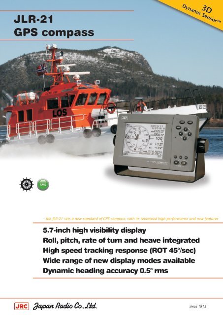
<strong>JLR</strong>-<strong>21</strong><strong>GPS</strong> <strong>compass</strong>Dynamic Sensor3DRMS– the <strong>JLR</strong>-<strong>21</strong> sets a new standard of <strong>GPS</strong> <strong>compass</strong>, with its renowned high performance and new features5.7-inch high visibility displayRoll, pitch, rate of turn and heave integratedHigh speed tracking response (ROT 45°/sec)Wide range of new display modes availableDynamic heading accuracy 0.5° rmssince 1915
<strong>JLR</strong>-<strong>21</strong>– featuresFeaturesThe <strong>JLR</strong>-<strong>21</strong> <strong>GPS</strong> <strong>compass</strong> continues the success of its predecessor, reaching a new levelof performance and stability with many new features and enhancements. This systemis also known as a 3D Dynamic Sensor, which besides giving heading information, isdesigned to provide highly accurate information of the ships movement in all axis.Heave compensationThe <strong>JLR</strong>-<strong>21</strong> has heave functionality built-in as standard. In rough oceanconditions (with high waves), the <strong>GPS</strong> <strong>compass</strong> can correct up anddown (attitude), movement. This is especially useful for fish findersand sonars on fishing vessels where high waves are compensated forHeaveOFFwith up to 20 cmaccuracy, providingbetter potential for aprofitable catch.SentenceATTHVEDataHeading, rolling, pitchingHeavingHigh speed updateThe <strong>JLR</strong>-<strong>21</strong> supports Speed Over Ground (SOG) and Course OverGround (COG). The position, SOG and COG are updated every 200milliseconds (which is 5 times faster than previous model <strong>JLR</strong>-20),delivering high accuracy.HeaveONDataHeading, ROT, rolling, pitching, heavingPosition, SOG, COGCycleEvery 20 milisecondsEvery 200 millisecondsHigh speed trackingThe <strong>GPS</strong> <strong>compass</strong> has its origins as adirection sensing system, but the <strong>JLR</strong>-<strong>21</strong>goes far beyond that. The <strong>JLR</strong>-<strong>21</strong> providesheading accuracy of 0.5°. Our other model(<strong>JLR</strong>-31) has an impressive 0.25° headingaccuracy. Heave accuracy is 20 cm orbetter and roll and pitch for both models is0.5°. The tracking Rate of Turn (ROT) is 45°per second.On the right a comparison betweenprevious <strong>GPS</strong> <strong>compass</strong> model (<strong>JLR</strong>-20) andthe new model (<strong>JLR</strong>-<strong>21</strong>).FeaturesRollPitchRate of TurnPositionHeaveHigh speed updateTrip logAnchor watchCCRPRMSTrend graph<strong>JLR</strong>-20VVVV<strong>JLR</strong>-<strong>21</strong>VVVVVVVVVVV<strong>JLR</strong>-<strong>21</strong><strong>GPS</strong> <strong>compass</strong> – a new level of performance and fea
<strong>JLR</strong>-<strong>21</strong>– advanced technologyDisplay modesThe <strong>JLR</strong>-<strong>21</strong> incorporates many display modes readily available ona highly visible 5.7 inch LCD display. The display is fully dimmableand the keys are also backlit, making it easy to operate in lowlightsettings on the bridge.Simple operationThe compact design of the <strong>JLR</strong>-<strong>21</strong> incorporates an intuitiveinterface, providing enhanced ergonomics and user friendliness.The logic of the controls and excellent on-screen menus willgreatly shorten most users’ learning period.Antenna designThe processor is built into the antenna. Eliminatingalignment between antenna and processor foundin separate systems, therefore contributing to aneasy setup with less error and significantly reducedinstallation time. This concept also reduces theinstallation costs as only a single cable is usedbetween antenna and display unit.The outer shell of <strong>JRC</strong>’s new antenna system hasa smooth surface. This slippery exterior makes italmost impossible for birds to perch on the domesor for the antennas to be completely covered insnow.snowlayer of air<strong>GPS</strong> sensor· <strong>JRC</strong> proven high performance antenna designShould something interfere with the coverage, <strong>JRC</strong>’sproven antenna design incorporates a layer of airthat reduces possible blind spots, allowing for amore precise heading than conventional systems.· Conventional antenna systemsnow<strong>GPS</strong> sensorNNN-<strong>21</strong>Installation and maintenanceThe <strong>JLR</strong>-<strong>21</strong> display is compactly designed and can be mounted virtuallyanywhere. The three-antenna system is exclusively designed by <strong>JRC</strong>, makingit far more reliable than conventional antenna systems. The system hasa short start-up time (less than 2 minutes). Maintenance is not required,making it less expensive to maintain than a standard gyro system.RMSRemote Maintenance System (RMS)<strong>JRC</strong> has the ability to cost-effectively monitor performance and functionality of the <strong>JLR</strong>-<strong>21</strong> while at sea,significantly reducing downtime and maintenance costs. More at jrceurope.com/support ▸tures
<strong>JLR</strong>-<strong>21</strong>– unique functionsMeasuring toolThe <strong>GPS</strong> <strong>compass</strong> allows calculationof distance and bearing betweenany two points, supporting RhumbLines (RL) for the short legs andGreat Circle (GC) for long distancelegs. Also, a trip log function comesstandard for distance and heading.CCRP andAnchor watchThe <strong>JLR</strong>-<strong>21</strong> has CCRP 1 functionincorporated, allowing the transferof CCRP sentences to other onboardequipment and anchor watch alertsthe watch officer of possible anchordragging situations.Trend graphThe new trend graph displaymode shows a history of roll,pitch and heave and SOG asan easy-to-read graphicalview. Selections can bemade to show maximum oraverage results.InterfacesThe new <strong>GPS</strong> <strong>compass</strong> integrates 5 independent working NMEA output ports, which allows forconnection to a wide range of onboard navigation equipment, such as radar, plotter, autopilot,sonar or other navigation devices.<strong>JLR</strong>-<strong>21</strong> and IMO recommendationsTraditionally, the means used to measure the heading of a ship has been a mechanical gyro<strong>compass</strong> and/or a traditional magnetic <strong>compass</strong>. With the adoption of the new installation requirements in SOLAS-V,all passenger ships and all ships from 300 to 500 GT travelling international routes can now install anew technology directional sensor, the Transmitting Heading Device (THD). <strong>JRC</strong>'s new <strong>JLR</strong>-<strong>21</strong> has beenapproved as both a THD and a GNSS (<strong>GPS</strong>).The approval allows forinstallation as a primaryheading device on vesselsup to 500 GT and forvessels over 500 GT,two or more could beinstalled as GNSS (<strong>GPS</strong>) orbackup heading devicedepending upon flag/class agreement.Periodic maintenanceSettling timeTracking responseAccuracyMagnetic influenceCorrection<strong>GPS</strong> <strong>compass</strong>Noapprox 2 min.High speedGoodNoNoGyro <strong>compass</strong>Yesabout 4 hoursHigh speedGoodNoYesfor latitudeMagnetic <strong>compass</strong>Yesfor correction deviationnoLow speedBadYesYesfor variationStandard in the box∙ Display∙ Antenna∙ Cables∙ Installation parts∙ Spare parts∙ ManualCables∙ Power cable display∙ Serial data cable∙ Display to antenna 22 m3 m10 mOptions∙ Serial data cable∙ Beacon ext. cable∙ Flush mount kit∙ AC power rectifier∙ D<strong>GPS</strong> receiverCFQ-5374 (3 m)CFQ-7250 (3 m data, 0,4 m pwr)MPBC43664NBG-320<strong>JLR</strong>-4341See all options jrceurope.com ▸1. Consistent Common Reference Point2.The cable length may vary depending on sales region.
<strong>JLR</strong>-<strong>21</strong>– size and weightDisplayNWZ-4701 Weight 2,3 kg85 mm5.7”142 mm20 mm230 mm268 mm70 mmCutout dimensionsfor flush mountingHeight 116 mmWidth 220 mmDepth 64 mmAntennaNNN-<strong>21</strong> Weight 5,9 kgbuilt in processor unit561 mm285 mm450 mm6<strong>21</strong> mmSystem diagramNNN-<strong>21</strong> (<strong>JLR</strong>-<strong>21</strong>) NNN-31 (<strong>JLR</strong>-31) <strong>JLR</strong>-4341 (D<strong>GPS</strong>)orSensor cable (10 m)Power 12V DC (for D<strong>GPS</strong> receiver)Power cable (2 m)12V to 24V DCSerial data cable (3 m)The standard scope of supply mayvary depending on sales region.RadarECDIS/<strong>GPS</strong> plotterCurrent meterAIS<strong>GPS</strong> repeconStandardOptionThe maximum cable length between antenna and display is 50 m. Note that extensions should be of a shieldedmulticore cable to prevent noise or attenuation.
<strong>JLR</strong>-<strong>21</strong>– specifications<strong>JLR</strong>-<strong>21</strong>IMO approvedJMA-9172-SA √Receiver typeFrequencyDirection accuracyMulti channel all-in-view (12ch + 1ch SBAS)1575.42MHz ± 1MHz (C/A code)0.5º rmsDisplay resolution 0.1ºResolution outputTracking Rate of TurnTracking acceleration0.1º or 0.01º (selectable)45º/sec1GRoll/pitch output -60º to 60ºStartup timeless than 2 minutes (warm start fix)D<strong>GPS</strong> input RTCM SC-104 version 2.0 (type 1, 2, 9, 16)SBAS receiverRAIM functionPosition accuracyDisplayOperating keys & backlightDimmer levelsDisplay modesOutput portsBuilt-in (WAAS/EGNOS/MSAS)Built-in12m 2drms (C/A code, HDOP=