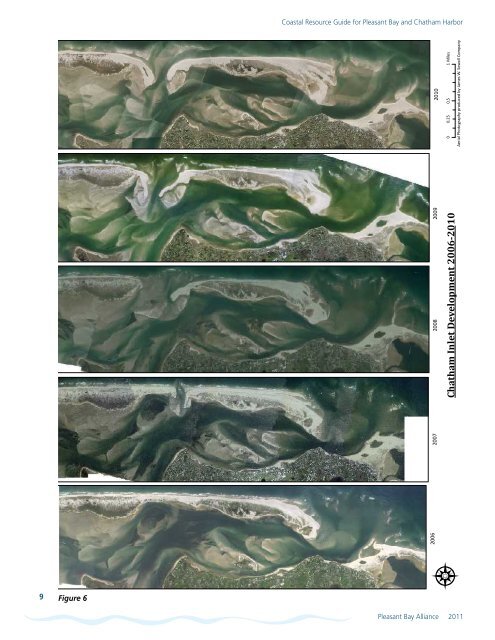
<strong>Coastal</strong> <strong>Resource</strong> <strong>Guide</strong> for <strong>Pleasant</strong> <strong>Bay</strong> <strong>and</strong> <strong>Chatham</strong> Harbor2006200720082009<strong>Chatham</strong> Inlet Development 2006-201020100 0.25 0.5 1 MilesAerial Pho<strong>to</strong>graphy produced by James W. Sewall Company9Figure 6<strong>Pleasant</strong> <strong>Bay</strong> Alliance 2011
<strong>Coastal</strong> <strong>Resource</strong> <strong>Guide</strong> for <strong>Pleasant</strong> <strong>Bay</strong> <strong>and</strong> <strong>Chatham</strong> HarborSection 3Wave <strong>and</strong> Tidal Conditions3.1 PurposeThe purpose of this section is <strong>to</strong> describe wave <strong>and</strong> tidal conditionsthat impact <strong>Pleasant</strong> <strong>Bay</strong> <strong>and</strong> <strong>Chatham</strong> Harbor. Wave conditionsinclude the intensity of waves generated in the Atlantic Ocean thatreach the barrier beach, as well as waves formed inside <strong>Pleasant</strong><strong>Bay</strong> <strong>and</strong> <strong>Chatham</strong> Harbor. The cycle of tides in <strong>Pleasant</strong> <strong>Bay</strong> <strong>and</strong><strong>Chatham</strong> Harbor is an important related physical process. Tides,along with wind <strong>and</strong> wave conditions, help <strong>to</strong> move sedimentalong the shoreline, as described in Section 4.3.2 Methodology - Outer Wave ClimateOcean waves reaching the outer barrier beach shoreline areinfluenced by meteorological conditions offshore in the Gulf ofMaine <strong>and</strong> do not represent conditions in <strong>Pleasant</strong> <strong>Bay</strong>. However,underst<strong>and</strong>ing the outer ocean wave climate is important becauseit is among the dominant forces shaping the barrier beach.The direction <strong>and</strong> intensity of ocean wave energy can be depictedby a wave rose. A wave rose graphically summarizes wave height,frequency, <strong>and</strong> direction. The wave rose for this resource guide wasderived from offshore Wave Information Studies (WIS) hindcastdata. The wave rose in Figure 7 illustrates the percentage of wavesthat arrive from a given directional b<strong>and</strong> <strong>and</strong> the distribution ofwave height within that direction b<strong>and</strong>.The WIS hindcast data provide a valuable source of long-termwave data, at dense spatial resolution <strong>and</strong> over a period oftime not available from measurements. The WIS uses his<strong>to</strong>ricalmeteorological data <strong>to</strong> calculate hourly wave conditions, whichare then verified against measurements from wave buoys. Theresultant data set is comprised of twenty years (1980-1999) ofwave information, including significant wave height, peak period,<strong>and</strong> direction once each hour.A relatively small change in wave direction could correlate <strong>to</strong>a major impact on s<strong>to</strong>rm damage for a portion of shorelineprotected by headl<strong>and</strong>s, which can shelter neighboring beaches.This protection is highly sensitive <strong>to</strong> the direction from which thewaves are coming. An open stretch of barrier beach (e.g., Nauset)is much less sensitive <strong>to</strong> small changes in the angle of wave attack.It should be noted that these roses are for an area greater than tenmiles offshore of <strong>Pleasant</strong> <strong>Bay</strong> <strong>and</strong> do not take in<strong>to</strong> considerationfine-scale geometry that can have a significant local impact onwind <strong>and</strong> waves. This data is presented <strong>to</strong> illustrate the generalwind <strong>and</strong> wave patterns for the portion of the coast exposed <strong>to</strong>ocean waves.3.2.1 Findings - Outer Wave ClimateWIS station 67 has a broad, but fairly consistent, wave directionfrom between 0 <strong>and</strong> 180 degrees (north-east-south) <strong>and</strong>approximately 95% of the waves during this time had a heigh<strong>to</strong>f less than two meters. The wave rose of the offshore WISwave hindcast station shows the relatively weak westerly waveSection HighlightsThe outer coastline is dominated by waves that donot originate from local wind conditions, but insteadare generated offshore in the Gulf of Maine. Theseoffshore winds have limited influence on waveconditions inside <strong>Pleasant</strong> <strong>Bay</strong> <strong>and</strong> <strong>Chatham</strong> Harbor.Local <strong>and</strong> seasonally variable winds as well asbathymetry (water depth) <strong>and</strong> fetch (distance windtravels over water) affect wave conditions in theinterior of the <strong>Bay</strong>. The summer is characterized bylower wind speed <strong>and</strong> a dominant wind directionfrom the southwest. Winter is characterized byprevailing northwest winds <strong>and</strong> higher wind speeds.Tides within <strong>Pleasant</strong> <strong>Bay</strong> <strong>and</strong> <strong>Chatham</strong> Harborare semi-diurnal (two tidal cycles per day) with anaverage range of approximately 6 feet in <strong>Chatham</strong>Harbor <strong>and</strong> 4.5 feet at Meetinghouse Pond inOrleans at the very head of Little <strong>Pleasant</strong> <strong>Bay</strong>. Thesetides are produced by the open continental shelf(Gulf of Maine) tides which, as they rise <strong>and</strong> fall,cause seawater <strong>to</strong> flow in<strong>to</strong> <strong>and</strong> out of the estuarythrough the tidal inlets that connect the two systems.conditions for the open ocean due <strong>to</strong> the shadowing effect of theOuter Cape. All stations show the trend of a higher quantity ofwaves from the south, but a larger significant wave height fromthe north. This indicates that over the course of a year seasonal(e.g. northeasterly) waves occur with similar frequency, but theoverall impact may be larger as the higher wave heights tend<strong>to</strong> approach from the same direction. The wave data is fromall months during the twenty-year period in order <strong>to</strong> depict anannual average wave condition free of seasonal trends. The windrose for the same station <strong>and</strong> time period (also shown on Figure7) shows that most of the wind is traveling from west <strong>to</strong> east,the opposite of prevailing ocean wave conditions. This indicatesthat offshore waves are more heavily influenced by conditions inthe Atlantic Ocean than nearby l<strong>and</strong>-derived winds. As such, thewave rose likely does not represent conditions within <strong>Pleasant</strong> <strong>Bay</strong>,but instead provides insight as <strong>to</strong> the energy impacting the outercoastlines of the barrier beaches.3.3 Methodology - Inner Wave ClimateThe waves within <strong>Pleasant</strong> <strong>Bay</strong> are influenced by the localwind regime. Estimating potential wave heights can be quitecomplicated <strong>and</strong> is very site specific, but generally is a functionof wind velocity, fetch, <strong>and</strong> duration of the wind. Atlantic Oceanwaves that may enter the system through inlets also may havesome influence on the <strong>Bay</strong>’s inner wave climate. While the 10<strong>Pleasant</strong> <strong>Bay</strong> Alliance 2011