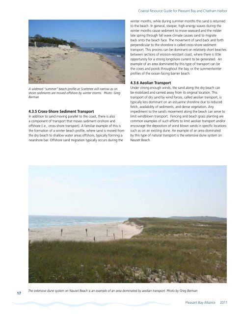
<strong>Coastal</strong> <strong>Resource</strong> <strong>Guide</strong> for <strong>Pleasant</strong> <strong>Bay</strong> <strong>and</strong> <strong>Chatham</strong> Harborwinter months, while during summer months this s<strong>and</strong> is returned<strong>to</strong> the beach. In general, steeper, high-energy waves during thewinter months cause sediment <strong>to</strong> move seaward <strong>and</strong> the milderlate spring through fall wave climate causes s<strong>and</strong> <strong>to</strong> migrateback on<strong>to</strong> the beach face. The movement of s<strong>and</strong> back <strong>and</strong> forthperpendicular <strong>to</strong> the shoreline is called cross-shore sedimenttransport. This process can be dominant on relatively short beachesbetween sections of erosion-resistant coast, where there is littleopportunity for a strong longshore current <strong>to</strong> be generated. Anexample of an area dominated by this type of transport can bethe coves <strong>and</strong> ponds throughout the bay, or the summer/winterprofiles of the ocean-facing barrier beach.A widened “summer” beach profile at Scatteree will narrow as onshore sediments are moved offshore by winter s<strong>to</strong>rms. Pho<strong>to</strong>: GregBerman4.3.5 Cross-Shore Sediment TransportIn addition <strong>to</strong> s<strong>and</strong> moving parallel <strong>to</strong> the coast, there is alsoa component of transport that moves sediment onshore <strong>and</strong>offshore (i.e., cross-shore transport). A familiar example of this isthe formation of a winter beach profile, where s<strong>and</strong> is moved fromthe dry beach <strong>to</strong> shallow water areas offshore, typically forming anearshore bar. Offshore s<strong>and</strong> migration typically occurs during the4.3.6 Aeolian TransportUnder strong enough winds, the s<strong>and</strong> along the dry beach canbe mobilized <strong>and</strong> carried away from its original location. Thistransport of dry s<strong>and</strong> by wind forces, called aeolian transport, istypically less dominant on an estuarine shoreline due <strong>to</strong> reducedfetch, availability of sediments, <strong>and</strong> dense vegetation. Anyimpediment <strong>to</strong> the s<strong>and</strong>’s movement along the beach can serve <strong>to</strong>limit windblown transport. Fencing <strong>and</strong> beach grass planting arecommon examples of such efforts <strong>to</strong> limit aeolian transport <strong>and</strong>/orencourage the deposition of wind blown s<strong>and</strong>s in specific locationssuch as on an existing dune. An example of an area dominatedby this type of natural transport is the extensive dune system onNauset Beach.17The extensive dune system on Nauset Beach is an example of an area dominated by aeolian transport. Pho<strong>to</strong> by Greg Berman<strong>Pleasant</strong> <strong>Bay</strong> Alliance 2011
<strong>Coastal</strong> <strong>Resource</strong> <strong>Guide</strong> for <strong>Pleasant</strong> <strong>Bay</strong> <strong>and</strong> <strong>Chatham</strong> HarborSection 5<strong>Coastal</strong> Structures5.1 PurposeThe purpose of this section is <strong>to</strong> describe <strong>and</strong> illustrate the type<strong>and</strong> distribution of coastal structures within the <strong>Pleasant</strong> <strong>Bay</strong>system. The function of coastal structures <strong>and</strong> their potentialimpacts <strong>to</strong> the coastal zone also are described.5.2 MethodologyThe type, number <strong>and</strong> distribution of coastal structures in <strong>Pleasant</strong><strong>Bay</strong> were derived from a combination of existing geospatialdata <strong>and</strong> local knowledge. In 1996, large-scale base maps withparcel boundaries produced by the Cape Cod Commission wereused by local resource managers (Harbormasters, Conservation,Environmental Staff) <strong>to</strong> map the approximate locations of coastalstructures around the <strong>Bay</strong>. The locations were then digitized by theCape Cod Commission for mapping purposes <strong>and</strong> a GIS databasewas created for the 1998 <strong>Pleasant</strong> <strong>Bay</strong> <strong>Resource</strong> ManagementPlan. The 1996 data was augmented with more recent datataken from field observations by local resource managers involvedwith the 2008 plan update. The location of many of the softshoreline structures were provided by conservation permittingrecords. Shoreline structures in the <strong>Chatham</strong> section are currentlybeing updated using information derived from aerial pho<strong>to</strong>graphy.5.3 <strong>Coastal</strong> Structures<strong>Coastal</strong> structures in <strong>Pleasant</strong> <strong>Bay</strong> include shorefront protectionstructures, as well as piers, docks, floats, <strong>and</strong> elevated walkways,etc. Shorefront protection structures (“hard structures”) <strong>and</strong> otherapproaches (“soft solutions” such as fiber rolls, pictured right)are used <strong>to</strong> manage shoreline erosion, especially on developedcoasts. Revetments, bulkheads, <strong>and</strong> gabions are examples of hardstructures, while soft structures or soft stabilization techniquesinclude fiber rolls, artificial dunes with beach grass plantings orfencing, <strong>and</strong> beach nourishment.Section Highlights<strong>Coastal</strong> structures in <strong>Pleasant</strong> <strong>Bay</strong> include shorefrontprotection structures <strong>to</strong> manage coastal erosion <strong>and</strong>docks <strong>and</strong> piers <strong>to</strong> provide water access. In 2007,approximately 160 piers <strong>and</strong> docks were locatedaround the <strong>Bay</strong>. These structures may impact coastalenvironments by altering water circulation <strong>and</strong>causing scour, or by shading vegetation.“Hard” shorefront protection structures includerevetments, bulkheads, <strong>and</strong> gabions. In 2007, therewere 132 hard structures around the <strong>Bay</strong>. Thesemostly permanent structures may affect sedimentdynamics along the shore by inhibiting bankerosion, causing scour near the base <strong>and</strong>/or end ofthe structure <strong>and</strong> lowering of beach profile on thefronting beach.Soft stabilization structures or solutions around the<strong>Bay</strong> include fiber rolls, artificial dunes with plantingsor fencing, <strong>and</strong> beach nourishment. They are fewer innumber (28), but have become increasingly common.Regula<strong>to</strong>ry agencies typically prefer soft shoreprotection solutions since they are less permanent<strong>and</strong> typically cause fewer impacts <strong>to</strong> the shore.The growing number of docks <strong>and</strong> piersin <strong>Pleasant</strong> <strong>Bay</strong> was a major impetusfor the <strong>Bay</strong>’s designation as an ACEC<strong>and</strong> the subsequent developmen<strong>to</strong>f a resource management plan forthe <strong>Bay</strong>. In an effort <strong>to</strong> assist <strong>to</strong>wnsaround the <strong>Bay</strong> in developing specificregula<strong>to</strong>ry or bylaw changes relative<strong>to</strong> the permitting of docks, piers,walkways <strong>and</strong> stairways, the <strong>Pleasant</strong><strong>Bay</strong> <strong>Resource</strong> Management Allianceissued <strong>Guide</strong>lines <strong>and</strong> PerformanceSt<strong>and</strong>ards for Permitting Docks <strong>and</strong> Piersin <strong>Pleasant</strong> <strong>Bay</strong> in 1999 <strong>and</strong> <strong>Guide</strong>linesfor Private Walkways <strong>and</strong> Stairways inFresh <strong>and</strong> Marine <strong>Resource</strong> Areas in<strong>Pleasant</strong> <strong>Bay</strong> in 2002. These documentsrecommend design criteria <strong>and</strong>performance st<strong>and</strong>ards for constructionof these structures in order <strong>to</strong> minimizeFiber rolls, considered a “soft solution,” can be covered over with vegetation <strong>to</strong> res<strong>to</strong>re a naturalappearance <strong>and</strong> functioning of a coastal bank. Pho<strong>to</strong>: Kristin Andres 18<strong>Pleasant</strong> <strong>Bay</strong> Alliance 2011