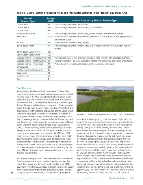
<strong>Coastal</strong> <strong>Resource</strong> <strong>Guide</strong> for <strong>Pleasant</strong> <strong>Bay</strong> <strong>and</strong> <strong>Chatham</strong> HarborTable 3. <strong>Coastal</strong> Wetl<strong>and</strong> <strong>Resource</strong> Areas <strong>and</strong> Freshwater Wetl<strong>and</strong>s in the <strong>Pleasant</strong> <strong>Bay</strong> Study AreaWetl<strong>and</strong><strong>Resource</strong> TypeAcreage(2007) Interests Protected by Wetl<strong>and</strong> <strong>Resource</strong> Type<strong>Coastal</strong> Bank 96 S<strong>to</strong>rm damage prevention, flood control<strong>Coastal</strong> Beach 113 S<strong>to</strong>rm damage prevention, flood control, wildlife habitat<strong>Coastal</strong> Dune 85Rocky Intertidal Shore 1 S<strong>to</strong>rm damage prevention, flood control, marine fisheries, wildlife habitat, shellfishSalt Marsh1,391 Marine fisheries, wildlife habitat, shellfish, prevention of pollution, s<strong>to</strong>rm damage prevention,groundwater supplyTidal flat 225 Marine fisheries, wildlife habitat, shellfishBarrier Beach System 41 S<strong>to</strong>rm damage prevention, flood control, wildlife habitat, marine fisheries, wildlife habitat,shellfishBarrier Beach-<strong>Coastal</strong> Beach 259Barrier Beach-<strong>Coastal</strong> Dune 650Wooded swamp – deciduous trees 116 Public/private water supply, groundwater supply, flood control, s<strong>to</strong>rm damage prevention,Wooded swamp – coniferous trees 38 pollution prevention, fisheries, <strong>and</strong> wildlife habitat. (Interests served by Bordering VegetatedWooded swamp – mixed trees 41 Wetl<strong>and</strong>s, which includes wet meadows, marshes, swamps <strong>and</strong> bogs.)Shrub swamp 264Shallow marsh, meadow or fen 48Deep marsh 20Cranberry bog 59Bog 425Salt MarshesApproximately 1,400 acres of salt marsh occur in <strong>Pleasant</strong> <strong>Bay</strong>,making these the most abundant <strong>and</strong> widespread coastal wetl<strong>and</strong>resource areas in the Atlas area. Hundreds of acres of salt marshborder the l<strong>and</strong>ward margin of the Nauset barrier, with the mostextensive marshes occurring in Little <strong>Pleasant</strong> <strong>Bay</strong> in the vicinity ofPochet, Sampson, <strong>and</strong> Hog Isl<strong>and</strong>s. Large areas of salt marsh alsoborder the tidal creek between Pochet Isl<strong>and</strong> <strong>and</strong> Pochet Neck <strong>and</strong>occur adjacent <strong>to</strong> Strong Isl<strong>and</strong> <strong>and</strong> just east of Little Sipson Isl<strong>and</strong>in <strong>Pleasant</strong> <strong>Bay</strong> (Sipson Meadow). Salt marshes are common insmall, protected inlets along the shore <strong>and</strong> fringe the edge of the<strong>Bay</strong> in low energy settings. Just over half of the 45-mile mainl<strong>and</strong>bay shoreline (i.e., not including the back-barrier margin of NausetBeach <strong>and</strong> North Beach Isl<strong>and</strong>) is fringed by salt marsh (Borrelli,2009). The comparatively smaller amount of fringing salt marshalong the mainl<strong>and</strong> shore of <strong>Chatham</strong> Harbor may be due <strong>to</strong> itsmore dynamic nature given its proximity <strong>to</strong> the 1987 <strong>and</strong> 2007inlets. A recent study of shoreline change in the <strong>Bay</strong> from 1868<strong>to</strong> 2005 using the marsh edge as a proxy for determining rates ofshoreline change found that the seaward margin of salt marsh iseroding around much of the <strong>Bay</strong> (See Section 2.3.3). Marsh edgeaccretion was documented only on the isl<strong>and</strong>s <strong>and</strong> along the bayside of Nauset Beach due <strong>to</strong> salt marsh development on washoverfans <strong>and</strong> subtidal shoals.Salt marshes are highly productive coastal wetl<strong>and</strong>s dominated bySpartina grasses that are comprised of three distinct zones: lowmarsh, high marsh, <strong>and</strong> the marsh border (Carlisle et al, 2002).Low marsh forms the seaward edge of the salt marsh <strong>and</strong> is usuallyflooded during every high tide <strong>and</strong> exposed at low tide. Smoothcordgrass (Spartina alterniflora), a tall salt-<strong>to</strong>lerant grass species,Salt marsh at Jackknife L<strong>and</strong>ing in <strong>Chatham</strong>. Pho<strong>to</strong> Credit: Carole Ridleyis the dominant plant growing in the low marsh. High marsh liesbetween the low marsh <strong>and</strong> marsh border, <strong>and</strong> is generally floodedonly during higher than average tides. Salt meadow hay (Spartinapatens), spike grass (Distichlis spicata), <strong>and</strong> black grass (Juncusgerardii) are the most common plant species comprising the highmarsh. A short form of smooth cordgrass may also be common inthis zone. Depressions, or pannes, in the high marsh hold waterfor extended periods, creating highly saline conditions that onlythe most salt <strong>to</strong>lerant plant species can withst<strong>and</strong>. High marshoccurs primarily in the upper sections of the <strong>Bay</strong> where areas of saltmarsh are more extensive, while fringing marshes along the lowerbay shoreline is typically low marsh. Large areas of high marsh inthe <strong>Bay</strong> were converted <strong>to</strong> low marsh between 1984 <strong>and</strong> 2000due <strong>to</strong> changes in tidal amplitude caused by inlet breaching <strong>and</strong>migration (Smith, 2009). However, there have been no net changesin marsh area within the <strong>Bay</strong>, <strong>and</strong> evidence of marsh dieback (e.g.,due <strong>to</strong> crab herbivory) has not been found. High marsh comprisesa relatively small amount of the overall area of salt marsh in the <strong>Bay</strong>(approximately 10%), with most of the remaining salt marsh aroundthe <strong>Bay</strong> being low marsh (Smith, 2010, Pers. Comm., 27 April).<strong>Pleasant</strong> <strong>Bay</strong> Alliance 2011
<strong>Coastal</strong> <strong>Resource</strong> <strong>Guide</strong> for <strong>Pleasant</strong> <strong>Bay</strong> <strong>and</strong> <strong>Chatham</strong> HarborThe marsh border along the upper edge of the salt marsh is onlyflooded during extreme astronomical tides or s<strong>to</strong>rm surges. Ahigher diversity of plants grows in this part of the marsh, includingboth herbaceous <strong>and</strong> woody plants such as high tide bush (Ivafrutescens), seaside goldenrod (Solidago sempervirens), <strong>and</strong> switchgrass (Panicum virgatum). Plants adapted <strong>to</strong> brackish conditionsoccur along the upper reaches of salt marshes <strong>and</strong> border tidalrivers <strong>and</strong> streams that discharge <strong>to</strong> the <strong>Bay</strong>.Tidal FlatsAlthough salt marsh is the most abundant intertidal habitat typein the <strong>Bay</strong>, other unvegetated intertidal environments (tidal flats)also exist including s<strong>and</strong> flat, mud flat, <strong>and</strong> cobble/pebble flats.Tidal flats reach their greatest extent in the upper reaches of the<strong>Bay</strong> between Sampson <strong>and</strong> Pochet Isl<strong>and</strong>s, <strong>and</strong> in the tidal inletbetween Pochet Isl<strong>and</strong> <strong>and</strong> Pochet Neck. Extensive tidal flats alsooccur south of Strong Isl<strong>and</strong>, in <strong>Chatham</strong> Harbor in the vicinityof Tern Isl<strong>and</strong>, <strong>and</strong> bordering some sections of the bay shore ofNauset Beach. The grain size composition of tidal flats is controlledprimarily by the velocity of tidal currents. Mudflats develop inlower energy settings such as small, protected coves in the upperbay, while s<strong>and</strong> flats occur in areas of high tidal current velocitynear barrier beach inlets <strong>and</strong> channels. The net transport of s<strong>and</strong>grains on a s<strong>and</strong> flat in any one direction is small because of theoscilla<strong>to</strong>ry nature of the tidal currents.The salt marshes <strong>and</strong> tidal flats in several parts of the <strong>Bay</strong> wereidentified in the <strong>Pleasant</strong> <strong>Bay</strong> <strong>Resource</strong> Management Plan as Areasof Critical Marine Habitat based on their significant habitat values(e.g., feeding <strong>and</strong> roosting areas for coastal waterbirds, habitatfor horseshoe crabs, diamondback terrapin, etc.) These areas(numbers correspond <strong>to</strong> areas shown on Map 11) include:#1• The intertidal zone <strong>and</strong> tidal flats north of Tern Isl<strong>and</strong>, south ofMinister’s Point, <strong>and</strong> west of the channel.#2• The intertidal zone <strong>and</strong> tidal flats surrounding the east, west<strong>and</strong> south sides of Strong Isl<strong>and</strong>.• The intertidal area of Nickerson’s Neck from the Strong Isl<strong>and</strong><strong>to</strong>wn l<strong>and</strong>ing <strong>to</strong> the southeastern tip of Fox Hill <strong>and</strong> from the<strong>Chatham</strong> Yacht Club north <strong>to</strong> the 7 th tee of the Eastward Ho!Country Club.• The intertidal zone <strong>and</strong> flats west of Nauset Beach from the2007 inlet north <strong>to</strong> Broad Creek <strong>and</strong> Hog Isl<strong>and</strong> Creek, <strong>and</strong> thesouth side of Hog Isl<strong>and</strong> <strong>and</strong> the west side of Sampson Isl<strong>and</strong> <strong>to</strong>its northern tip.• The intertidal zone from the southwest end of the Narrows (justnorthwest of Sipson Isl<strong>and</strong>) <strong>to</strong> the eastern end of the Winslowrevetment, <strong>and</strong> the intertidal zone <strong>and</strong> flats surrounding LittleSipson Isl<strong>and</strong>.• The intertidal zone along south shore of Barley Neck.Submerged eelgrass in <strong>Pleasant</strong> <strong>Bay</strong>. Pho<strong>to</strong>: Cape Cod CooperativeExtension/Woods Hole Sea Grant#3• The intertidal zone from in Little <strong>Pleasant</strong> <strong>Bay</strong> from NamequoitPoint west <strong>to</strong> the entrance of Pah Wah Pond.• The intertidal zone from the conservation property on the southside of Kent’s Point, <strong>and</strong> along both sides of The River <strong>to</strong> Meetinghouse Pond (including Frost Fish Cove).Eelgrass BedsEelgrass beds are highly productive, subtidal plant communitiesthat provide nursery <strong>and</strong>/or feeding habitat for many fish,waterfowl <strong>and</strong> invertebrate species (Costa, undated). Loss ofeelgrass can result in significant shifts in marine fauna, includingcommercial <strong>and</strong> recreational species. The degradation of eelgrassbeds in the 1930s from an outbreak of wasting disease causedbay scallop s<strong>to</strong>cks <strong>to</strong> crash <strong>and</strong> brant geese population numbers<strong>to</strong> plummet. Because eelgrass grows underwater, these importanthabitats often go unnoticed except by boaters, shellfishermen,<strong>and</strong> divers. Eelgrass is highly sensitive <strong>to</strong> pollution (e.g., nitrogenloading) <strong>and</strong> serves as an ideal indica<strong>to</strong>r of water quality changes.Over 1,800 acres of eelgrass occurs in <strong>Pleasant</strong> <strong>Bay</strong>, reflecting thehigh habitat <strong>and</strong> water quality of areas within the <strong>Bay</strong> (Howes,et al 2006). Map 12 shows the distribution of eelgrass mappedduring 1995 <strong>and</strong> 2001 surveys. 1 The most extensive eelgrass bedsare located in Little <strong>Pleasant</strong> <strong>Bay</strong>, the central section of <strong>Pleasant</strong><strong>Bay</strong> around Sipson Isl<strong>and</strong> <strong>and</strong> west of Strong Isl<strong>and</strong>. Eelgrass bedsalso exist in the tidal creek between Sampson Isl<strong>and</strong> <strong>and</strong> BarleyNeck. Significant eelgrass habitat also exists in Bassing Harbor <strong>and</strong>the tidal river between Barley Neck <strong>and</strong> Pochet Isl<strong>and</strong> (althoughsome eelgrass in these areas was mapped only during the 1995survey). Smaller patches of eelgrass are scattered in the shallowsubtidal zone west of the Nauset Barrier Beach. Eelgrass coveragein the <strong>Bay</strong> has declined by approximately 24% over the last halfcentury (except <strong>Chatham</strong> Harbor) <strong>and</strong> the density of eelgrass inexisting beds may be thinning (Howes et al, 2006). Anecdotally,the health eelgrass beds appear <strong>to</strong> be increasing in Little <strong>Pleasant</strong><strong>Bay</strong>, possibly due <strong>to</strong> improved water quality (Farber, 2010, Pers.Comm., 7 February). However, the system-wide eelgrass decline inthe <strong>Bay</strong> is linked <strong>to</strong> environmental changes associated with nutrientenrichment (Howes et al, 2006).1 Eelgrass mapped during the 1995 survey but not during the 2001 survey may have disappeared, or may not have occurred in sufficient density <strong>to</strong> be mapped.26<strong>Pleasant</strong> <strong>Bay</strong> Alliance 2011